Written By

As a U.S. Fish and Wildlife Service Wildlife Biologist and a passionate duck hunter, I always feel a strong sense of anticipation as we approach the start of the annual Waterfowl Breeding Population and Habitat Survey, also known as the May Survey. However, this year was different. For the first time in 18 years, I had the opportunity to return to the skies and fly right-seat as Mark Koneff’s observer. Mark is a long-term veteran in the Migratory Bird Program and is not only one of our skilled Pilot Biologists, but he is also Chief of our Migratory Bird Surveys Branch.
Although I have participated in the May Survey in the past, most of my experiences have been in the western prairies where colorful dabbling ducks such as the mallards, northern shovelers, gadwall, and blue-winged teal fill the potholes. I knew Maine and the Atlantic Provinces were going to be a little different with black ducks, green-winged teal, ringnecks, goldeneyes, mergansers, and even a few scoters being the dominate species on the wetlands. Excited at the promise of returning the to field, my May Survey preparation began with brushing up on my duck ID (which is a challenge when you’re flying at 100-150’ above ground-level and at 90 knots!) and getting current on all the required aircrew aviation training.
While I was busy completing my Aviation Survival and Egress Training, Mark was keeping a very close eye on the spring temperatures to ensure the start of the survey corresponded to the breeding phenology of the birds. The start of the survey in each crew area is timed when most ducks are on territories and have started making nests.

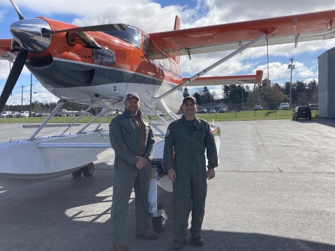
During March and April, Maine and the Atlantic Provinces experienced wildly flip-flopping temperatures, but overall spring was advanced across most of the region. Given the warmer than normal spring temps, I arrived in Bangor, ME on April 30th, almost a week or so earlier than Mark’s normal start. After a thorough briefing on all the features of our Daher Kodiak 100 Amphibian aircraft and safety and survival equipment, we were wheels up on the afternoon of May 1st.
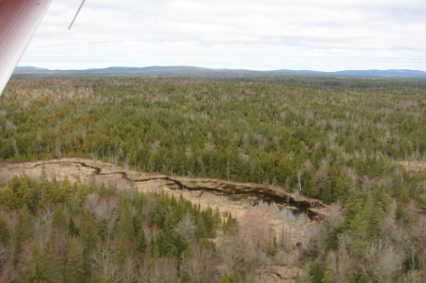
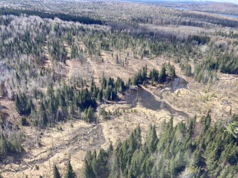
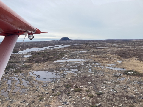
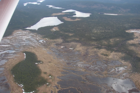
Unlike the potholes, stock ponds, and dugouts in the Prairie Pothole Region, Maine and the Maritime Provinces include a really wide range of wetlands: large lakes, rivers, streams, wooded swamps, beaver ponds, sedge meadows, and peat bogs cover the landscape. After only a couple hours of flying and gazing at the landscape below I was immediately struck by the huge role beavers play in creating breeding duck habitat in the Atlantic Flyway.
In general, winter and early spring precipitation was about average in northern Maine and New Brunswick, but it was evident that parts of the area were still recovering from previous years of dry conditions. With lower-than-average precipitation in April and early May, many of the ponds there had dry margins but I’m hopeful they will still provide for good duck production. As we moved closer to the southern and coastal regions, winter and spring precipitation was slightly above average resulting in better wetland conditions and good potential for duck production.
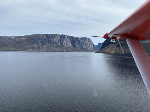
After spending about a week in Fredericton, New Brunswick and Halifax, Nova Scotia, we made the trek across the Gulf of St. Lawrence to Stephenville, Newfoundland. Newfoundland, or “The Rock,” was honestly one of the most unique places I’ve ever seen for breeding waterfowl. Of note were the string bogs, which contained elevated ridges and thin islands alternating with wet sedge and mossy areas. These ridges often formed across the water flow, giving the wetlands a wide ladder type of appearance. While really interesting to look at, these string bogs coupled with very rocky wetlands certainly added a new challenge to finding and counting ducks. While Newfoundland had abundant water and duck breeding habitat, it was easy to see that many of these wetlands contained low nutrient levels, which is in sharp contrast to the highly productive wetlands of the western prairies and parklands. The Newfoundland landscape was truly spectacular, rugged, and untouched ranging from 2000 ft-deep landlocked fjords in the west to traditional rocky coastlines in the east interspersed with rolling tundra, boreal forest, and lots of rocks in between. We finished our transects in Newfoundland and after a quick stay in St. Anthony we pushed northward to Labrador.
The Atlantic Provinces are notorious for harsh weather conditions with wind, rain, and fog making for impossible low-level flying conditions. However, over the first 2 and a half weeks of the survey, Mark and I were truly fortunate to have a solid string of great flying days with light winds and blue skies and only a couple of down days where we couldn't fly. As always, all good things eventually come to an end. With only about 4 days of flying left, several offshore low-pressure systems kept us “weathered-in” in Goose Bay, Labrador for over a week. Although I was starting to experience a little bit of cabin fever, Mark reminded me that it’s “Always better to be on the ground wishing you were in the air, than be in the air wishing you were on the ground!” Point taken! The break wasn’t all bad. While many wetlands in the interior had already experienced spring thaw, winter still had a bit of a grip on the larger lakes and ponds especially in the higher elevations on Labrador. When we did finally get back out, much of the ice had receded and we saw good numbers of waterfowl, but it was apparent that portions of Labrador have been experiencing drier than average conditions recently.
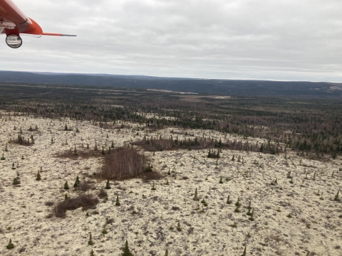
Even in some of the most remote areas of Maine, New Brunswick, Prince Edward Island, and Nova Scotia there’s was always some evidence of anthropogenic impacts on the landscape. Forestry activities, agriculture, roads, power lines, cell and communication towers, and other types of infrastructure were almost always visible at any given time. However, Labrador was seemingly untouched. In some areas we literally flew for 100 miles without any evidence of human impacts on the landscape. As far as the eye could see, the dark green spruce fir/boreal forest just popped against light green lichen or “caribou moss” that blanketed the ground. It made me happy knowing that wild places like this still exist.
As we wrapped up, I found the flight back to Maine somewhat bittersweet. After a month away, I was certainly very excited about getting back to my family and again spending weekends at my kids’ baseball tournaments, but at the same time I was a little sad to see this year’s survey come a close. I couldn’t help but reflect on the countless hours of planning that it takes to pull off a safe and successful survey each year. Mark and his crew work tirelessly to plan flights, ensure our aircraft are in tip-top shape, and identify and mitigate the risks associated with low-level flight. I saw firsthand the exceptional aviation skills necessary to fly these low-level surveys and navigate the surrounding terrain. This just isn’t a job for our Pilot Biologists, it truly is a passion and lifestyle with a commitment that few will truly appreciate. As I sit at my desk back in Washington, D.C., I can’t help but feel incredibly proud to be a small part of the 70+ year history of the of the Service’s Waterfowl Breeding Population and Habitat Survey and I look forward to future holds. I was grateful for the opportunity, and I hope it’s not another 18 years before I get to take to the skies once again.
Latest Stories