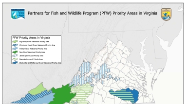
This map of Virginia shows polygons of the 7 priority work areas for the Partners for Fish and Wildlife (PFW) Program, including the Big Sandy River Watershed Priority Area, the Clinch and Powell Rivers Watershed Priority Area, the Holston River Watershed Priority Area, the New River Watershed Priority Area, the James Spinymussel Priority Area, the Roanoke Logperch Priority Area, and the Blackwater and Nottoway Rivers Watershed Priority Area. The Big Sandy River Watershed Priority Area, the Clinch and Powell Rivers Watershed Priority Area, the Holston River Watershed Priority Area, and the New River Watershed Priority Area are all located in Southwestern Virginia. The James Spinymussel Priority Area is located in one large unit in North-Central Virginia and one very small unit in South-Central Virginia. The Roanoke Logperch Priority Area is located in two units in South-Central Virginia and one unit is partially overlapping with the Blackwater and Nottoway Rivers Watershed Priority Area in Southeastern Virginia. The Blackwater and Nottoway Rivers Watershed Priority Area is one unit located in Southeastern Virginia, inland from Norfolk. Boundaries for most of the priority areas are based on the United States Geological Survey's hydrologic unit boundaries, while the James Spinymussel and Roanoke Logperch Priority Areas are based on species habitat modeling information. All priority areas were selected for their potential to benefit federally listed and at-risk species. Virginia Ecological Services staff continue to have statewide programmatic responsibility but will focus on these identified priority areas. This map was prepared by the Virginia Ecological Services Field Office on December 1, 2021. For additional information, please contact David Byrd at 804-824-2412.

