Photo By/Credit
USFWS
Date Shot/Created
07/11/2024Media Usage Rights/License
Public Domain
Image
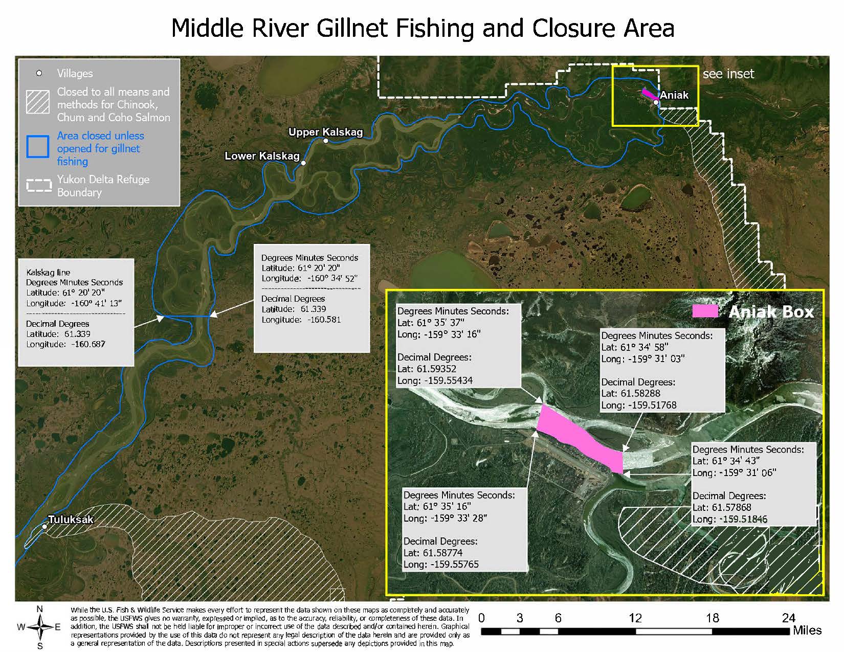
A map of the middle Kuskokwim River from about 3 miles downriver of Tuluksak up to Aniak and down river east past Aniak. A blue line outlines areas on both sides of the river the entire length shown and says that fishing is closed unless opened for gillnet fishing from Tuluksak to Aniak. A blue line boundary downriver from Lower Kalskag and about 20 miles north of Tuluksak with arrows pointing to both sides of the shore. The left arrow leads to text: Kalskag line. Degree Minutes Seconds. Latitude: 61, 20, 20. Longitude: -160, 41, 13. Decimal Degrees- Latitude: 61.339. Longitude: -160.687. The right arrow on the west side of the river shore has an arrow pointing to the respective end point of the boundary line. The text leading from the arrow: Degrees Minutes, Seconds, latitude: 61, 20, 20. Longitude: -160, 34, 52. Decimal Degrees. Latitude: 61.339. Longitude: -160.581. Upriver, a magenta line highlights an area of the river about 2.5 miles west of Aniak. The map calls out the Aniak Box with the North and South west sides of the magena line indicating coordinates: Northwest: Degrees Minutes Seconds: Latitude: 61, 25, 37. Longitude: -159, 33, 16. Decimal Degrees: 61.59352. Longitude: -159.55434. Southwest: Degrees Minutes Seconds: Latitude: 61, 35, 16. longitude: -159, 33, 28.
Decimal Degrees: Latitude: 61.58774. Longitude: -159.55765. The Northeast Side: Degrees, Minutes, Seconds: Latitude: 61, 34, 58. Longitude: -159, 31, 03. Decimal Degrees: Latitude: 61.58288. Longitude: -159.51768. Southeast: Degrees Minutes Seconds: Latitude: 61, 34, 43. Longitude: -159, 31, 06. Decimal Degrees: Latiude: 61.57868. Longitude: -159.51846.
While the U. S. Fish & Wildlife Service makes every effort to represent the data shown on these maps as completely and accurately as possible, the USFWS gives no warranty, expressed or implied, as to the accuracy, reliability, or completeness of these data. In addition, the USFWS shall not be held liable for improper or incorrect use of the data described arid/or contained herein. Graphical representation provided by the use of this data do not represent any legal description of the data here in arid are provided only as a general representation of the data. Descriptions presented in special actions supersede any depictions provided in this map.