Proposed Expansion of Roanoke River National Wildlife Refuge Alternative A Map

Document - application/pdf
Proposed Expansion of Roanoke River National Wildlife Refuge Alternative A Map

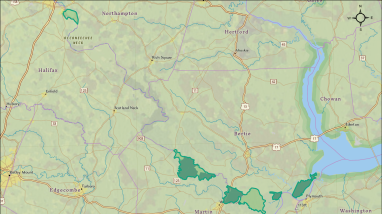
This map from the draft Land Protection Plan for Roanoke River National Wildlife Refuge and Environmental Assessment shows Alternative A (the No-Action Alternative). The map shows the existing Roanoke River NWR Approved Acquisition Boundary and current Refuge Lands in relation to the Northampton, Halifax, Bertie, Martin and Washington County boundaries and nearby towns. For accessibility assistance, please contact the refuge at 252-794-3808.

Publication date
Type of document
Map
Facility
A calm river bordered by bare baldcypress trees
Roanoke River National Wildlife Refuge, in Bertie County, North Carolina, is named for the Roanoke River, which runs through the refuge. The refuge was established in 1991 to protect the forests in the Roanoke River floodplain, considered to be the largest intact, and least disturbed, bottomland...
Subject tags
Wildlife refuges
Landscape conservation
Wetlands
Riparian areas
FWS and DOI Region(s)