Roanoke River National Wildlife Refuge Proposed Expansion Alternative B Prioritized Lands Map

Document - application/pdf
Roanoke River National Wildlife Refuge Proposed Expansion Alternative B Prioritized Lands Map

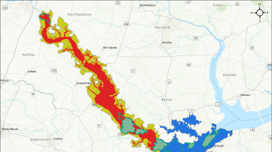
This map, from the draft Land Protection Plan for Roanoke River National Wildlife Refuge and Environmental Assessment, depicts how lands within the Proposed CPA boundary are prioritized by location and significance to wildlife. The map shows the current approved acquisition boundary, refuge lands, the proposed conservation partnership area, and, within the proposed conservation partnership area, areas of Priority 1, 2, and 3. For accessibility assistance, please call the refuge at 252-794-3808.

Publication date
Type of document
Map
Facility
A calm river bordered by bare baldcypress trees
Roanoke River National Wildlife Refuge, in Bertie County, North Carolina, is named for the Roanoke River, which runs through the refuge. The refuge was established in 1991 to protect the forests in the Roanoke River floodplain, considered to be the largest intact, and least disturbed, bottomland...
Program
A bright blue sky obstructed by fluffy white clouds reflected off of a stream shot from inside a kayak
The U.S. Fish and Wildlife Service manages an unparalleled network of public lands and waters called the National Wildlife Refuge System. With more than 570 refuges spanning the country, this system protects iconic species and provides some of the best wildlife viewing opportunities on Earth.
Subject tags
Wildlife refuges
Landscape conservation
Wetlands
Riparian areas
FWS and DOI Region(s)