Upper Mississippi River Refuge 100 Anniversary Stormy Weather Event Maps

Document - application/pdf
Upper Mississippi River Refuge 100 Anniversary Stormy Weather Event Maps

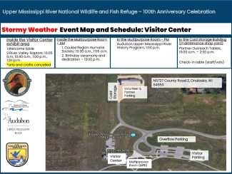
These maps show the changes to the La Crosse District 100th Anniversary event offerings and event activity locations if we have extended periods of stormy weather on June 22, 2024. 

Author(s)
Publication date
Type of document
Map
Facility
Sun setting behind the bluffs on the Upper Mississippi River
Upper Mississippi River National Wildlife and Fish Refuge has been a haven for migratory birds, fish, wildlife and people since 1924. The refuge stretches 261 river miles from Wabasha, Minnesota to Rock Island, Illinois, and protects more than 240,000 acres of Mississippi River floodplain. The...
Media Usage Rights/License
Public Domain
Program
A bright blue sky obstructed by fluffy white clouds reflected off of a stream shot from inside a kayak
The U.S. Fish and Wildlife Service manages an unparalleled network of public lands and waters called the National Wildlife Refuge System. With more than 570 refuges spanning the country, this system protects iconic species and provides some of the best wildlife viewing opportunities on Earth.
FWS and DOI Region(s)