Image
Refuge Ranger
Additional Role(s)
Volunteer Coordinator - La Crosse District
Area
WI
MN
Onalaska,WI
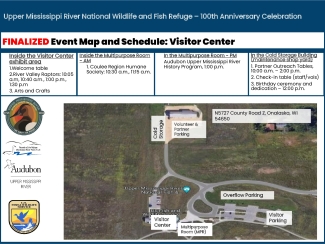
This is our FINAL rain plan map for 100th Anniversary event activities taking place at the La Crosse District Visitor Center on June 22, 2024. This map shows the location of where event activities hosted at the Visitor Center will take place. Activities at the boat landing will be determined on the morning of the event - boat tour participants will be notified by 8am if the boat rides are cancelled. The WI DNR will make a last minute decision on the safety of the fish shocking demonstrations. If they aren't able to do live demonstrations, they will bring the boat to the Visitor Center to talk about at the cold storage building.
| Attachment | Size |
|---|---|
| upper-mississippi-river-refuge-final-100th-anniversary-event-map-for-visitor-center-activities-june-22-2024.pdf278.5 KB | 278.5 KB |