

Visit Us
Located at the junction of State Highways 99W and 22, the refuge offers convenient access to miles of dirt trails as well as handicap and stroller accessible viewing platforms for its human visitors. The refuge kiosk just off Highway 22 provides an interpretive and informative experience for visitors, so make sure to stop at the pull-off to learn more about the refuge habitats and how they are maintained for wildlife. The HWY 22 kiosk and Rich Guadagno Memorial Trail are open year-round, but all other trails are closed from October 1 through March 31 to provide sanctuary for wintering dusky Canada geese and other waterfowl.
Refuge Access
The refuge is open from dawn to dusk. The refuge is located at the junction of State Highways 99W and 22 and can be accessed via Coville and Smithfield Roads off of Highway 99W. Refuge trailheads, viewing pull offs and parking areas can be found off of each. Parking is allowed in designated parking areas only. No overnight parking is allowed on the refuge.
What to Do
Start at our Observation Platform off Highway 22 and to view interpretive panels detailing Refuge management practices, native habitats and wildlife, and historic aspects of the land. And don't forget to pick up our complex brochure and trail maps at kiosks throughout the Refuge so you can learn more about the refuge complex.
Trails
Baskett Slough NWR has both year-round and seasonal trails. Seasonal trails are specified in their description and are open from April 1st - September 30
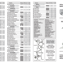
Download Our Trails Brochure: Trail Descriptions Baskett Slough NWR
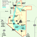
Here is a refuge map to help you find trailheads and other viewing spots! Baskett Slough NWR Map
Visit our homepage to view any current alerts, including trail closures.
Please note, dogs are not allowed on any refuge trails.
Trails, Viewpoints & Boardwalks
Highway 22 Wildlife Viewing Kiosk

Location:2.5 miles west of Highway 22/99W Intersection
Open: Year Round
Viewpoint description: Stop at this scenic kiosk to enjoy views of Baskett Slough’s wetlands and green hillsides. This kiosk is a
great place to stop to view the hundreds of migrating waterfowl that use the wetlands of Baskett Slough National Wildlife Refuge. Look for herons, shorebirds, coyotes wandering across the fields, and more! Explore the interpretive signs to learn more about the refuge’s amazing wildlife, history of the Willamette Valley National Wildlife Refuge Complex, and more.
Baskett Butte Loop Trail

Distance: 1.5 miles round trip
Open: Year Round
Difficulty: Easy
Type of trail: Loop
Trailhead location: Start this trail by hiking the Rich Guadagno Trail. Walk up the hill – take a right at the fork to begin the loop trail.
Trail description: This trail loops through oak woodlands and mixed forest. In the spring this trail is great for viewing migratory songbirds.
Listen for Spotted Towhees, Ruby-crowned Kinglets and Bewick’s wrens as you hike through the woodlands. This trail is also home to wintering songbirds and woodpeckers like Acorn Woodpeckers and rare wildflowers like the Kincaid's Lupine.
Morgan Lake Trail

Distance: 1.7 miles one way
Open: April 1 - Sept 30
Difficulty: Easy
Type of Trail: Out and Back
Trailhead location: From Pacific Highway West, turn onto Smithfield Road and continue straight for 2 miles. This out and back trail starts at a parking area located at the junction of Smithfield and Livermore Road on the north side of the refuge.
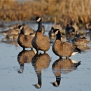
Trail description: Walk to Morgan Lake, where you can spot Canada geese, Mallards, and Cinnamon Teal. Listen for Red-winged Blackbirds and Marsh Wrens. Enjoy views of the Refuge, then choose to return or connect to other trails.
Rich Guadagno Memorial Trail

Distance: 0.4 miles one way
Open: Year Round
Difficulty: Easy with moderate uphill
Type of Trail: Out and Back
Trailhead location: The Rich Gudadagno trailhead parking area is located just off Coville Road in the middle of the refuge.
Trail Description: Learn about the legacy of Rich Guadagno and be rewarded with 360 views from the overlook platform. At the platform you will get a great view of the many wetlands that encompass the southern part of the refuge. In the winter, you can see thousands of migratory waterfowl using the wetlands. Restrooms are available at the trailhead near the parking lot.
Related Documents
See what birds are visiting, feeding, roosting and nesting! Take the Willamette Valley NWRC Bird List with you on your Refuge adventure.
Other Facilities in the Complex
Baskett Slough National Wildlife Refuge is managed as part of the Willamette Valley National Wildlife Refuge Complex. A National Wildlife Refuge Complex is an administrative grouping of two or more refuges, wildlife management areas or other refuge conservation areas that are primarily managed from a central location. Refuges are grouped because they occur in a similar ecological region and have a related purpose and management needs. These refuges for example, were created in the 1960s specifically for the habitat they provide for the dusky Canada geese in the winter.
The Willamette Valley National Wildlife Refuge Complex consists of three refuges: William L. Finley NWR and its additional Snag Boat Bend Unit, Ankeny NWR and Baskett Slough NWR.

Rules and Policies
There are lots of fun, interesting, and educational things you can do on the refuge. Keep in mind, if an activity is not wildlife related and doesn’t help in the protection or understanding of wildlife or their habitat, there are probably refuge rules governing this activity. For example, no pets are allowed at the Refuge. See details and all rules and regulations, below.
Locations


The refuge is located at the junction of State Highways 99W and 22 and can be accessed via Coville and Smithfield Roads off of Highway 99W. Refuge trailheads, viewing pull offs and parking areas can be found off of each. Parking is allowed in designated parking areas only. No overnight parking is allowed on the refuge.