Visit Us
National wildlife refuges offer us all a chance to unplug from the stresses of daily life and reconnect with our natural surroundings. Pocosin Lakes National Wildlife Refuge provides numerous recreation opportunities to visitors every year. People enjoy viewing the unique habitats and diverse wildlife, whether driving, boating, biking, or hiking. Stop by the Walter B. Jones, Sr. Center for the Sounds in Columbia to explore the interactive displays and take a stroll along the Scuppernong River Boardwalk—sunsets over the Scuppernong are a must-see! Head to the Pungo Unit to see black bear, winter waterfowl, and other wildlife. Pocosin Lakes NWR offers excellent wildlife photography opportunities, especially in early mornings and late afternoons, when wildlife is most active and lighting can be spectacular.
Activities
Watching and photographing wildlife is popular on the refuge. Waterfowl observation (during the winter) and bear watching (nearly year-round) are the most popular, but other birds and wildlife are plentiful on Pungo as well. Walking and hiking is permitted anywhere on the refuge unless the area is posted as closed. Bicycling is allowed on all established roads and trails designated as open to the public. In addition, there are opportunities for deer and feral hog hunting and fishing in the many canals on the refuge. The refuge offers education programs and tours, as well as opportunities for school and youth group education programs. Boating is allowed on the refuge on Alligator and Scuppernong Rivers, Frying Pan Lake, and on New Lake from February through November. Horseback riding is only allowed with a Special Use Permit (contact the refuge for details).
When on the refuge, keep safety in mind at all times. It’s important to remember that no matter how cute or calm an animal might appear one minute, things can change instantly. Do not approach or feed wildlife, and do not allow wildlife to approach in close proximity. Keep safe distances from female wildlife and their offspring.
Please observe all signage and do not enter any areas marked closed. Sometimes, roads have to be temporarily closed because they become impassable. Please contact our offices to receive the most up-to-date information on road closures for the Pungo Unit. In addition, some roads have posted weight limits and cannot support vehicles heavier than a typical pickup truck or standard SUV. Be aware of road signs indicating weight limits and closures. During the deer hunting season, all visitors must wear orange if away from their vehicles.
Trails
The refuge offers several trails to experience the habitats and wildlife on the refuge. The Scuppernong River Interpretive Boardwalk is located behind the Visitor Center in Columbia; the Duck Pen Wildlife Trail is located on the Pungo Unit off of South Lake Road.
In addition to these two interpretive trails, the refuge has more than 170 miles of unimproved roads with no or limited (hunting season) vehicle access open to hiking, biking, and walking. The roads are typically mowed on three year cycles, so grass and other vegetation may be dense on some roads. Watch out for ticks and snakes when hiking through vegetation. Some roads may parallel the refuge boundary. Be respectful of adjacent private land.
Related Documents
Other Facilities in the Complex
The refuge is managed as part of the Coastal North Carolina National Wildlife Refuge Complex. A National Wildlife Refuge Complex is an administrative grouping of two or more refuges, wildlife management areas or other refuge conservation areas that are primarily managed from a central office location. Refuges are grouped into a complex structure because they occur in a similar ecological region, such as a watershed or specific habitat type, and have a related purpose and management needs.
There are 9 national wildlife refuges in the Coastal North Carolina National Wildlife Refuges Complex. The Project Leader for the Complex supervises the Refuge Managers who are responsible for managing these refuges. However, there are five distinct and separate administrative offices. Alligator River and Pea Island National Wildlife Refuges are administered from the Alligator River National Wildlife Refuge Headquarters in Manteo, NC. An administrative office at the Mackay Island National Wildlife Refuge Headquarters in Knotts Island, NC manages both Mackay Island and Currituck National Wildlife Refuges. An office at Mattamuskeet National Wildlife Refuge administers Mattamuskeet, Swanquarter, and Cedar Island National Wildlife Refuges. Pocosin Lakes National Wildlife Refuge, Roanoke River National Wildlife Refuge, Great Dismal Swamp National Wildlife Refuge, Back Bay National Wildlife Refuge, and Edenton National Fish Hatchery each have separate administrative offices.
All of the Coastal North Carolina National Wildlife Refuges, Great Dismal Swamp National Wildlife Refuge, Back Bay National Wildlife Refuge, and Edenton National Fish Hatchery are open to public visits for nature-based recreational enjoyment. Priority public uses are hunting, fishing, wildlife observation, wildlife photography, environmental education, and interpretation.
Rules and Policies
In addition to these provisions, all State laws, County codes, and Title 50 of the Code of Federal Regulations apply on the Refuge. If you have any questions about the legality of any activity, please contact the Refuge Manager.
General Regulations
- The Refuge is open during daylight hours only (1/2 -hour before sunrise to 1/2 -hour after sunset).
- Camping, open fires, feeding or baiting of wildlife, swimming in Refuge canals, or entering any area posted with “Area Closed” signs is prohibited.
- All domestic pets (dogs, cats, horses, etc.) must be properly confined, leashed (10-foot maximum), or haltered and under owner control at all times.
- Littering or dumping of garbage, refuse, sewage, debris, or other wastes or poisons is prohibited.
- The use of a spotlight, automotive headlight, or other artificial light to spot, observe, locate, or take any animal is prohibited.
- Taking, possessing, injuring, disturbing, damaging, destroying, or collecting any plant or animal (or attempting these actions) is prohibited.
- Destroying, defacing, damaging, disturbing, or removing any private or public property, including any natural object or artifact, is prohibited. The use or possession of metal detectors or similar devices is prohibited.
- Disturbing, molesting, or interfering with any person engaged in an authorized activity is prohibited. Engaging in any act of indecency or disorderly conduct (as defined by State or local laws) is prohibited.
- Entering or remaining on the Refuge when under the influence of alcohol or a controlled substance is prohibited.
- Begging or soliciting in any form or conducting a commercial enterprise on the Refuge is prohibited unless authorized by a Commercial Special Use Permit.
- Refuge visitors are reminded that hunting is allowed during specific seasons. Be cautious and courteous when visiting areas shared with other refuge users. If stepping away from a vehicle during hunting season, visitors should wear orange for visibility.
Vehicles/Roads/Trails
- The speed limit on all Refuge roads, unless otherwise posted, is 25 miles per hour. State traffic laws that govern the use and operation of vehicles apply on the Refuge.
- Motorized vehicles are allowed only on designated roads.
- Refuge roads closed to motorized vehicles are open for walking and bicycle riding, unless posted as closed to bicycles or closed to all entry.
- Operating any vehicle or boat that does not bear valid license plates or identification numbers and that is not properly lighted, certified, registered, or inspected according to State laws is prohibited. ATVs (3-wheelers, 4-wheelers, dirt bikes, etc.) and non-registered UTVs are prohibited.
- Stopping or parking a vehicle (either attended or unattended) on a road, trail, or firelane such that it blocks the free movement of other vehicles is prohibited.
Locations
The Walter B. Jones, Sr Center for the Sounds is the Pocosin Lakes NWR Visitor Center. Visitors can explore exhibits about the history, wildlife, and management of Pocosin Lakes NWR, ask questions about the refuge, or take a walk on the Scuppernong River Interpretive Boardwalk, which starts just behind the visitor center. The refuge administrative office is located on the other side of the covered deck.
The Administrative Office and the Walter B. Jones Center for the Sounds (the refuge Visitor Center) are located on US Highway 64 in Columbia, NC at 205 South Ludington Dr.
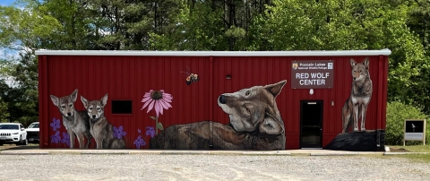
The Red Wolf Center is located in Columbia, NC on Pocosin Lakes National Wildlife Refuge. In addition to providing space to conduct regular health checks on the wolves, the center has a small reception area for the public and an established viewing area for a pair of captive red wolves.
Red Wolf Programs are offered with staffing availability. See the calendar below for current program schedules.
Program schedule
You can also call 252-796-3004 to find out when red wolf programs are offered.
Red wolves are the most endangered wolf in North America. Learn more about the Red Wolf Recovery Program.
About the Center
The Red Wolf Center, located one mile south of Columbia, NC on NC Highway 94, was constructed in 2007. The fence enclosures behind the Center were constructed in 2012 using funds secured by the Red Wolf Coalition, a refuge partner. A ribbon cutting ceremony was held that year with guest of honor Congressman Walter B. Jones, Jr.
The building is divided into two sections. The health care side is equipped to help Service biologists to safely handle wolves needing medical treatment. The education side houses exhibits and educational material about red wolves. The fence enclosures behind the building are used to temporarily hold wolves receiving health checks or care and to permanently house a pair of exhibit wolves. Seating has been installed just outside the exhibit enclosure. All of the fence enclosures are surrounded by another, perimeter fence to ensure the safety of the captive animals and help prevent animals from escaping.
Exhibit wolves cannot be released in to the wild due to injury or other reason. Red wolves normally shy away from people, and sometimes the exhibit wolves like to hide in the den or at the rear of the enclosure. Since the Red Wolf Center is now their home, please understand that we do not disturb the exhibit wolves to make them more visible for viewing.
Next steps for the Center include developing interactive exhibits to more thoroughly tell the story of world's most endangered wolf.
The Red Wolf Center, is located 1 mile south of Columbia, NC on Highway 94. The Center is on the east side of the road (on your left as you approach from Columbia). Apple Maps has an incorrect location for the Center--please use written directions or a different navigation app to find the Center.
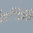
The Pungo Unit is the most popular area for wildlife observation on the refuge. Large numbers of swans, snow geese, and other waterfowl can be seen using the Unit's wetlands, agricultural fields, moist-soil units, and the waters of Pungo Lake. In addition, large numbers of bears can be seen in the refuge agricultural fields and adjacent forests. Lucky observers may see a rare sighting, such as a sandhill crane.
There are approximately 44 miles of roads on the Pungo Unit. All of them are dirt surface and can get slippery and rough during wet periods and dusty during dry periods. Some of the open roads on the Pungo Unit are closed to vehicles from November through February to reduce disturbance to waterfowl. Sometimes, roads have to be temporarily closed because they become impassable. In addition, the Pungo Unit may be closed during the special permit-only deer hunts on certain Fridays and Saturdays in September and October. Closed roads are shown on the map in this brochure and/or posted with signs. Please contact our offices to receive the most up-to-date information on road closures for the Pungo Unit.
The Pungo Unit can be accessed off Highway 45, 18 miles south of Plymouth, NC. There is an informational kiosk with maps of the unit at the intersection of Highway 45, Pat’s Road, and Refuge Road.


