About Us
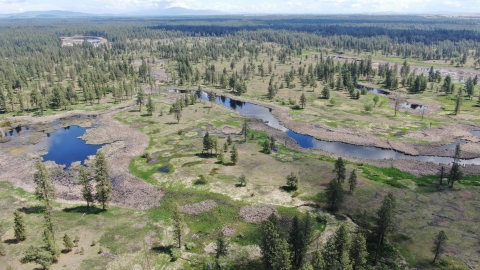
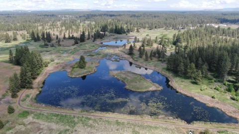
Turnbull National Wildlife Refuge, established in 1937 by Franklin D. Roosevelt, encompasses over 23,000 acres of the Channeled Scablands habitat of eastern Washington. The ecosystem that predominates the refuge is unique within the National Wildlife Refuge System and has characteristics that distinguish it from natural reserves worldwide with its broad diversity of plants and animals. The powerful forces of volcanism, glaciation and the largest floods in geological history have combined to forge a distinct environment. The combination of basalt outcrops, flood eroded channels, and ponderosa pine forests infused in a diverse landscape of over 130 marshes, wetlands and lakes, create an environment of aesthetic beauty as well as high quality wildlife habitat. Refuge ecosystems represent an ecological transition between the dry, sagebrush sagebrush
The western United States’ sagebrush country encompasses over 175 million acres of public and private lands. The sagebrush landscape provides many benefits to our rural economies and communities, and it serves as crucial habitat for a diversity of wildlife, including the iconic greater sage-grouse and over 350 other species.
Learn more about sagebrush dotted grasslands of the Columbia Basin and the timbered Selkirk and Bitterroot Mountain Ranges that rise up to the east. The more than 3,000 acres of wetlands on Turnbull NWR represent some of the last quality breeding habitat available in eastern Washington for waterfowl, which have experienced tremendous population declines across North America due to loss and degradation of breeding, migration, and wintering habitat. The area serves as an important link in migrations for at least 139 species of birds, but its best function is a production area for at least 100 bird species. Habitat diversity provides a stable, productive and flexible resource to ensure that the native faunal diversity of the Refuge is maintained. The Refuge restores and maintains ecosystem processes that provide for a natural diversity of flora and fauna native to the wetland, aspen, riparian riparian
Definition of riparian habitat or riparian areas.
Learn more about riparian , steppe, and ponderosa pine communities of eastern Washington. Maintenance of biodiversity is further supported by the conservation of threatened and endangered species.
Our Mission
The mission of the National Wildlife Refuge System is to administer a national network of lands and waters for the conservation, management and, where appropriate, restoration of the fish, wildlife and plant resources and their habitats within the United States for the benefit of present and future generations of Americans.
The mission of Turnbull NWR is to restore and maintain ecosystem processes that provide for a natural diversity of flora and fauna native to the wetland, steppe and ponderosa pine communities of the Channeled Scablands of eastern Washington.
Our History
The Refuge is located within a globally unique geological area known as the Channeled Scablands, created by massive scouring from Ice Age floods 15,000 years ago. An extensive complex of deep permanent sloughs, semi-permanent potholes and seasonal wetlands formed in the depressions left in the scoured landscape. These wetlands formed in large part as a result of the eruption of Mount Mazama approximately 7,700 years ago. A layer of ash up to two feet thick sealed the fractured basalt bedrock which helped create the current mosaic of wetland basins in the region. The geographic region is further defined by soils only centimeters thick on upland sites, which supports primarily ponderosa pine forest intermixed with grasslands (steppe) and exposed basalt cliffs. Aspen is scattered throughout the area. The juxtaposition of all these contrasting habitats in such close proximity is unique to the Channeled Scablands and creates conditions of exceptional wildlife and plant diversity.
| Pre-Settlement | Prior to human settlement, ducks, geese, and other water birds nested in the area in large numbers. Many waterfowl also used the productive marshes and lakes during the spring and fall migrations. Lakes were deeper and marshes more extensive than today, with sloughs draining to the northeast only after melting snows and rains filled them to capacity. Much of the land was under water continuously. |
8000 BCE (thru Present) | Because of its unique resources, this area is important to local indigenous cultures. The Southern Plateau peoples frequented this vicinity in spring to dig the roots of camas, bitterroot, wild onion and numerous species of Lomatium, and to gather waterfowl eggs. Collection of these roots continues to this day. The refuge also provided ideal hunting grounds for deer and elk. While salmon were and are the major source of dietary protein for the Southern Plateau peoples, there is no evidence that fishing was of primary importance within or in proximity to the refuge. The bodies of water at Turnbull are shallow and subject to seasonal drying. As such, native species of fish could not have tolerated these seasonal variations. |
| 1812 | Ross Cox, a fur trader with the Pacific Fur Company becomes separated from the rest of his party somewhere north of the Palouse River while traveling north on the so-called Colville Trail that joined the Snake River and Colville region. He spends the next 15 days traveling solo before rejoining his compatriots at the Spokane House near the confluence of the Spokane and Little Spokane Rivers. During this time, he passes by the general vicinity of the refuge. Cox's recollections are noteworthy, providing colorful, and perhaps the earliest written descriptions of the area's wetlands long before the arrival of Euro-American settlers and colonizers. While not a scientist, Cox's accounts of the numbers of, and variety of wildlife in the area was considerably greater than in modern times. |
| 1859 | An early road, called the Mullan Road, crossed the refuge near Stubblefield Lake. |
| 1872 | European-American settlers and colonizers arrive and rapidly began altering the landscape. Daniel Percival settled on Pine Creek near present-day refuge headquarters. |
| Late 1800s | Many of the marshes were drained to expand crop areas for hay. However, the wetlands around Turnbull remained a barrier well into the 1880s. When the issue of where to locate the county seat of Spokane County was debated, citizens of Spangle voiced loud objection to Cheney (then called Depot Springs) because of the difficulty posed by the lakes and wetlands present at Turnbull. By 1881, the Northern Pacific Railroad had laid track from Portland to Spokane. In 1883, the transcontinental line was complete, which provided connections with the Midwest and East Coast. Washington becomes a state on November 11, 1889. |
| Early 1900s | Between 1906 and 1908, the Spokane, Portland, and Seattle Railway constructed a track through what is today the western portion of the refuge. Anecdotes from that time claim that the blasting of basalt rock required to lay the track was responsible for lowering the water table in the nearby wetlands. Today, this old railroad grade is accessible as part of the Columbia Plateau Trail. |
| 1912 | The land settled by Daniel Percival passed ownership to the Pine Creek Dairy. This land consisted of 1800 acres, including a natural spring, and was the largest farm inside of what would become Turnbull NWR. |
| 1920s | Few wetlands remained unaltered; instead a network of drainage ditches and expansive hay meadows became the more common feature of the landscape. In addition, as in most developing communities, timber was harvested, native plant communities were grazed by livestock, exotic plants were introduced, and fire, a natural part of the ecosystem, was suppressed. The wildlife values of the area would have been seriously compromised if it had not been for the failure of the drained lakebeds to produce crops. |
| 1929 | The Migratory Bird Conservation Act is passed, providing impetus for the creation of federal wildlife refuges around the country. |
| 1937 | President Franklin D. Roosevelt establishes the "Turnbull Migratory Waterfowl Refuge" on July 30, 1937 (Executive Order 7681) "as a refuge and breeding ground for migratory birds and other wildlife." Nearly all of the lands comprising the new refuge come from privately owned farms, including the Pine Creek Dairy. Turnbull was in the first group of refuges purchased with Duck Stamp Funds. Local activists, sportsmen, and naturalists were instrumental in obtaining the areas designation as a National Wildlife Refuge (Press Release). The Refuge was named after early settler Cyrus Turnbull, who built a cabin on the north end of Turnbull Slough (then called Turnbull Lake) and lived there with his wife and children from 1880 to 1886. The name "Turnbull" has origins in Scottish folklore. According to the folktale, a brave farmer jumped on the back of a raging bull and turned it away from the king that was standing nearby. Ironically, Cyrus Turnbull never actually owned the land he was living on; rather, he exercised so-called "squatters rights." In an 1885 census of Spokane County, Cyrus Turnbull listed his occupation as "farmer." However, family lore states that Cyrus dedicated most of his energy and interest to hunting. Meat was scarce in the newly developing Cheney, so venison and waterfowl were welcome substitutions for beef and poultry. Cyrus would later move to northern Idaho, where he established his final homestead and remained there until his death in 1934. Despite his short tenure in the wetlands, his name remained attached to an area that experienced rapid changes in ownership over the next half century until the establishment of the refuge. |
| 1938 | John D. Connors is appointed the first Refuge Manager of Turnbull NWR. He begins the process of removing dams and dykes needed to restore the area's wetlands, a process that continues to this day. |
| 1940s | Beginning in 1938, crews from the Works Progress Administration (WPA) begin removing farm buildings and fencing on the refuge. Despite the early removal of over 100 buildings, the job of demolishing structures went unfinished for years. In 1946, Refuge Manager Ralph C. Winslow is quoted as saying "the aesthetic value of the refuge is high, but it is greatly marred by a few scattered, unoccupied, unpainted old buildings which greatly detract from its beauty." Some buildings were repurposed for use by the USFWS, including some as a refuge headquarters and others to serve as housing for government employees and student interns. By 1940, WPA men had erected buildings at the at the new refuge headquarters (the site of the old Pine Creek Dairy) and constructed a 99-ft-tall fire tower overlooking Turnbull Sloughs. By the mid-1940s, 22 water control structures had been installed, completely controlling and redirecting the drainage of the refuge. This decade was also a time of prolific road-building. In 1943, the road now used as the Auto Tour Route was constructed for fire patrol and to more easily provide access to lakes for wildlife habitat management purposes rather than for the visiting public. Many of these roads were never used as intended and later became hiking trails, such as the Bluebird Trail. |
| 1950s | Removal, salvage, and adaptive use of existing structures persisted throughout the decade. A new manager's house was built in 1955 and first occupied by Refuge Manager Wilber A. Rogers. |
| 1960s | A wildfire begins on July 7, 1960 along the Union Pacific Railroad tracks (present Columbia Plateau Trail) and spreads east across the refuge. A majority of the remaining structures are consumed in the blaze. The refuge begins an ambitious effort to restore trumpeter swans to eastern Washington. |
| 1984 | The first great blue heron rookery ever found on the refuge was reported. It was located near the Lower Turnbull Lake water control structure and contained approximately 10 nests. Estimated total production was 9 young. |
| 1994 | New entrance signs were installed, including the entrance to the Public Use Area along Cheney-Plaza Road. These signs were carved from large blocks of redwood. The Public Use Area sign also featured a pair of redhead ducks. |
| 2008 | Construction began on what is the current headquarters building. Occupancy began in 2010. The previous headquarters building and fire cache were demolished. |
Other Facilities in this Complex
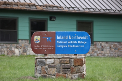
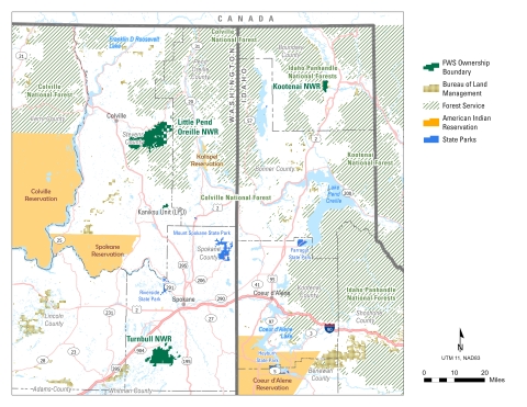
Turnbull National Wildlife Refuge is managed as part of the Inland Northwest National Wildlife Refuge Complex. A National Wildlife Refuge Complex is an administrative grouping of two or more refuges, wildlife management areas or other refuge conservation areas that are primarily managed from a central office location. Refuges are grouped into a complex structure because they occur in a similar ecological region, such as a watershed or specific habitat type, and have a related purpose and management needs. Typically, a project leader or complex manager oversees the general management of all refuges within the complex and refuge managers are responsible for operations at specific refuges. A complex often shares common work priorities and budgets. Shared supporting staff, composed of administrative, law enforcement, refuge manager, biological, fire, visitor services, and maintenance professionals, are centrally located and support all refuges within the complex.
Other lands in the Inland Northwest National Wildlife Refuge include: two National Wildlife Refuges, several subunits, and conservation easements in northeastern Washington and northern Idaho. Turnbull National Wildlife Refuge, located just outside Cheney, Washington, serves as the complex headquarters. Turnbull is a 2-3 hour drive from Little Pend Oreille and Kootenai Refuges, respectively.
Despite common management oversight, each of the three complex refuges is unique.
Turnbull NWR
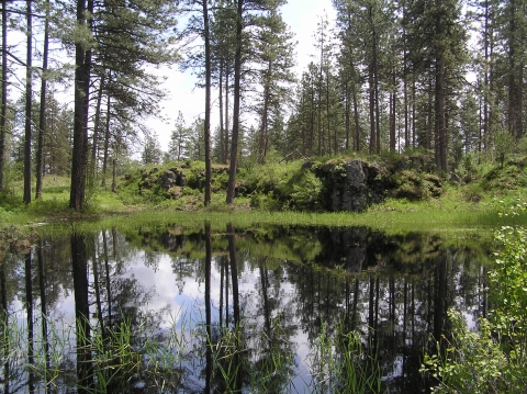
Turnbull features over 130 wetlands, ponderosa pine forest, steppe grassland, aspen, and rock outcroppings set in a distinctive landscape that offers many possibilities for experiencing nature.
Location: Southwest of Spokane, in Spokane County, Washington in the “Channeled Scablands”
Purpose: “. . . as a refuge and breeding ground for migratory birds and other wildlife (EO 7681, July 30 1937) and “. . . for use as an inviolate sanctuary, or for any other management purpose, for migratory birds.”
Acreage: over 23,000 acres
Habitat: The Refuge supports an extensive complex of deep permanent sloughs, semi-permanent potholes and seasonal wetlands formed in the depressions left in a landscape scoured by Ice Age floods over fifteen thousand years ago. The uplands are a mixture of ponderosa pine, Palouse steppe, basalt outcrops and scattered aspen.
Public Use: Turnbull attracts an estimated 49,500 annual visitors to its 3,300-acre public use area. Wildlife observation is the primary use but hiking and bicycling on the auto tour are also popular. In 2010 Turnbull offered its first elk and youth waterfowl hunts.
Established: 1937
Little Pend Oreille NWR

Little Pend Oreille is a mountainous forested refuge with clear streams, scattered lakes, and diverse outdoor pursuits.
Location: In Stevens and Pend Oreille counties, Washington in an area dubbed the Forgotten Corner.
Purpose: “. . . as a refuge and breeding ground for migratory birds and other wildlife (EO May 1939) and “. . . for use as an inviolate sanctuary, or for any other management purpose, for migratory birds.”.
Acreage: 42,594
Habitat: Six forest types including ponderosa pine, Douglas fir, grand fir, cedar, western hemlock, subalpine fir as well as 60 miles of stream, lakes, and wetlands.
Public Use: Little Pend Oreille attracts about 60,000 visitors annually who hunt, fish, view and photograph wildlife, hike, mountain bike, camp, horseback ride, cross country ski and snowshoe.
Established: 1939
Kootenai NWR

Kootenai is a small gem of diverse wetland, cropland, and upland habitats and recreational opportunities.
Location: West of Bonners Ferry, Idaho in Boundary County’s scenic Kootenai River Valley
Purpose: “. . . as a refuge and breeding ground for migratory birds and other wildlife." (June 24, 1964 approved by MBCC Memorandum).
Acreage: 2,774 acres
Habitat: Provides diverse habitats including wetlands, forests, streams, and riparian riparian
Definition of riparian habitat or riparian areas.
Learn more about riparian areas as well as crops for foraging wildlife.
Public Use: Wildlife observation, wildlife photography, walking, bicycling, hunting, interpretation.
Established: 1964