

The Four-Square-Mile Survey was originally developed by scientists at USGS Northern Prairie Wildlife Research Center as a means of assessing the contribution of National Wildlife Refuge System land, in the Prairie Pothole Region, to continental waterfowl populations. This survey has been conducted since 1987 and continues presently.
Each year since 1987, biologists from the U.S. Fish and Wildlife Service (Service) can be seen traversing the prairie, moving from pothole to pothole scanning the wetlands for breeding duck pairs. This data is collected as part of a comprehensive breeding waterfowl monitoring program conducted in the Prairie Pothole Region known as the “Four-Square-Mile Survey”. The Four-Square-Mile Survey (FSMS) was designed to assess differing rates of waterfowl use on federally owned lands, conservation easements, and private lands, as well as provide estimates of breeding duck populations within and among different wetland management districts. The HAPET offices, which have conducted the FSMS since 1990, presently sample 704 survey plots twice annually - in May and early June. Pair surveys are conducted on 5,750 “pair ponds” throughout the U.S. portion of the Prairie Pothole Region. Pair survey data are integrated with annual remote sensing of wetland conditions on approximately 77,000 wetland basins to produce estimates of breeding pair abundance of 13 duck species and production estimates for the five most common duck species (mallard, northern pintail, blue-winged teal, gadwall, and northern shoveler). Field data is collected primarily by Service staff from their respective field stations. Data from this survey has also been used to target easement acquisition, evaluate effects of conservation programs, inform Farm Bill programs, monitor landscape change, assess wetland dynamics, guide evaluation of the effects of wind energy development on waterfowl, and provide baseline data used in development of spatially explicit models for waterfowl and non-game birds. The FSMS and its products were models for the concept of Strategic Habitat Conservation, which was recently adopted by the Service.
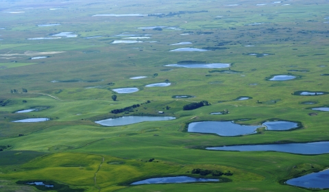
Another major benefit provided by the FSMS is the HAPET offices' extensive records of annual water conditions for 70,000 wetlands, which include the second driest drought of the 20th century and the wettest period in the past 130 and possibly 500 years. These data are being incorporated into a variety of projects that use this long-term, rigorous dataset to assess potential impacts of climate change climate change
Climate change includes both global warming driven by human-induced emissions of greenhouse gases and the resulting large-scale shifts in weather patterns. Though there have been previous periods of climatic change, since the mid-20th century humans have had an unprecedented impact on Earth's climate system and caused change on a global scale.
Learn more about climate change in the Prairie Pothole Region, including determination of mechanisms influencing wetland water levels, improvement of wetland monitoring programs, and modeling of response to climate change by wetland- dependent birds.


