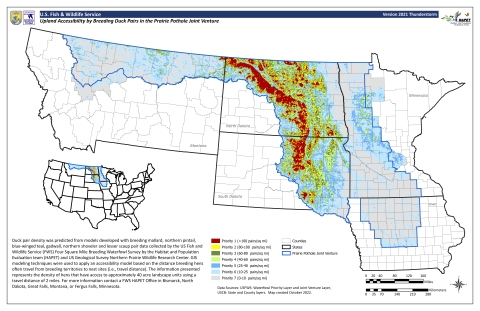
One of the most recognized HAPET products is the “Thunderstorm Map.” This map was an outcome of the Multi Agency Approach to Planning and Evaluation (MAAPE) process that was conducted during the early years of the Prairie Pothole Joint Venture (PPJV). The MAPPE effort highlighted the need for a tool that could be used to identify and prioritize upland nesting cover to protect for nesting waterfowl. The HAPET offices used a combination of National Wetlands Inventory (NWI) wetland data, pair/wetland relationship models, and distances that hen mallards, blue-winged teal, northern pintails, gadwall, and northern shovelers commonly travel from wetlands to upland nesting sites. The result of this model is the ability to compare grassland across the landscape and prioritize conservation based on levels of biological benefit.
Our duck priority map has been used extensively by PPJV partners to prioritize and target the conservation and management of uplands in areas with access by high densities of breeding pairs of ducks. Examples include targeting the conservation of native grassland using fee purchases or grassland easements and the restoration of grass cover by the USDA Conservation Reserve Program.