Eighteen miles of hiking in the mountains with 5,000 feet of elevation gain in one day – yes, please?
When I first learned about the arduous Snow Lakes trek taken by Leavenworth National Fish Hatchery staff, and that they do it every year, multiple times a season, I wanted to know more – not only for the physical challenge, but I was also curious about why they do it.
My very basic understanding was that every year, a valve is opened in July and closed in October, somewhere up in the mountains, miles away from the Leavenworth National Fish Hatchery. In between those months, hatchery staff and others make the hike up to the lakes and valves to adjust the amount of water flowing out of an outfall, which makes its way into Icicle Creek. Being someone who can’t resist a little (a lot) of type II fun* in the wilderness, I joined them on one of their outings to learn more.
*Type II Fun = Difficult when it’s happening but lots of fun when looking back.
This was my first time to Leavenworth, Washington, and at first glance, it was already living up to the hype I had heard from other outdoor enthusiasts. Leavenworth is a charming Bavarian-themed town tucked in on the east side of the Cascade Range, surrounded by steep mountains, running rivers, and vast and scenic wilderness that serves as the gateway to the Enchantments, a region in the Cascades known for its beauty and concentration of tall peaks and pristine alpine lakes.
Within this stunning landscape, the historic Leavenworth National Fish Hatchery sits along Icicle Creek, with a backdrop of those big mountains to the west and Wenatchee River to the east. Established in 1940, Leavenworth National Fish Hatchery was the first of a complex of hatcheries built to compensate for the effects of the Grand Coulee Dam, and at that time, was the largest fish hatchery in the world.
Grand Coulee Dam was built on the Columbia River between 1933 and 1941 to provide water for irrigation, power generation, flood control, and more; however, it also created a barrier, blocking the movement of fish to the river above it. The Leavenworth hatchery complex, including the Leavenworth, Winthrop, and Entiat National Fish Hatcheries, was built in the early 1940s to offset the losses of fish above the dam, raising and releasing fish into the rivers to enhance wild populations and provide food for natural predators and fishing opportunities for Tribal and sport anglers.
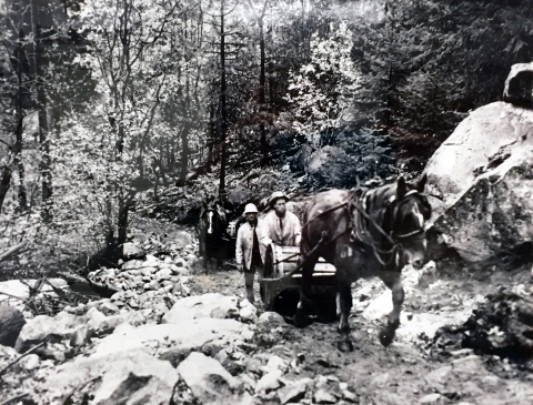
But to establish a successful fish hatchery, there needed to be reliable access to cold, clean water. In 1938, crews of horses and people built a trail that led to a water source high up in the mountains, establishing the water diversion from Snow Lakes for Leavenworth National Fish Hatchery, still used today.
At Leavenworth…crews forged a trail up into the nearby mountains, creating a route that would later become popular access to what is today the Alpine Lakes Wilderness. The trail led to Snow and Nada lakes, which were dammed to trap snowmelt in summer. Engineers from the Bureau of Reclamation blasted through 2,500 feet of solid granite, forming a tunnel to draw water from the lakes through a valve. To this day, that alpine water still feeds into Icicle Creek when hatchery workers open the valve in summer, bringing critical cool water to fish habitat and hatchery salmon. - What We Do
Today, that trail is well known by hikers as the Snow Lakes Trail, accessed from the Snow Lakes Trailhead, just two and a half miles down Icicle Road from the Leavenworth National Fish Hatchery. However, getting to the lakes themselves takes a substantial effort with a steep hike, roughly 9 miles one way from the trailhead.
Making the Trek
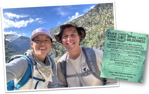
On a recent September morning, I joined Leavenworth hatchery manager Mat Maxey to learn for myself what the work and the journey involves. We started at the trailhead in pre-dawn darkness; Maxey was all smiles, equipped with a light pack, trekking poles, and a headlamp.
We filled out our day-use permit and set off in the dark toward the steep switchbacks. Maxey explained some of the various pieces of infrastructure we passed along the way – an irrigation ditch, fish screen, and one of three stream gauges along this route, this one measuring the amount of water flowing from Snow Creek into Icicle Creek.
Maxey set a good pace, and we chatted much of the way up, stopping only to take off or put on an extra layer. It was a particularly humid day, with a chance of rain and highs of 60s in the forecast – nearly perfect hiking weather, save for the humidity.
The first two miles were very steep, akin to walking up an endless, rocky staircase. The benefit of being guided by seasoned hatchery staff meant frequent, well-planned, beautiful rest stops. They were always by water, with a nice fallen log to sit on and plenty of shade.
By our first stop, dawn had broken, and I could see the views of the mountains and the lovely forest glade that Maxey had promised. It was evident Maxey had done this hike many times; somewhere between 20 and 30 times was their best guess.
After a quick break, we continued, gaining elevation up large and uneven granite steps, as the sounds of American pika calling became regular and louder. “MEEWP!”, they would squeak, and Maxey and I would occasionally stop to pinpoint where the sound was coming from, to then find one of these adorably round, potato-sized, rabbit-related fur balls calling from the top of a log or a boulder, hiding in plain sight.
A little past mile five, we came upon Nada Lake with its glassy reflection of the surrounding terrain. At Nada Lake’s dam is the second of three stream gauges along this route, this one measuring and validating release values and the natural decreases in water between the lake and the output in Icicle Creek. From behind Nada Lake, I could see and hear water spilling down the canyon in a roar.
What would look like a powerful waterfall to an unknowing hiker is the water released out of the tunnel that was blasted out of the granite back in the early 1940s. That water, sourced from upper Snow Lake where we were headed, is released every summer to supplement water into Icicle Creek as the Leavenworth hatchery diverts water for hatchery operations.
The Icicle Creek Work Group, convened by the Washington Department of Ecology’s Office of Columbia River and Chelan County, is a collaborative effort for water management in Icicle Creek, including local, state and federal agencies, Tribes, and agricultural and environmental groups. The quantity of water released, measured in cubic feet per second, or CFS, is carefully calculated by the work group to meet water demands and ensure the guiding principles of the Icicle Strategy are upheld, including enhancing and maintaining sustainable hatchery operations at Leavenworth.
The work conducted on this trek ensures that Leavenworth’s staff are regularly evaluating and offsetting the hatchery’s water withdrawals during the lowest flow time of the year, resulting in minimal impacts to Icicle Creek from the hatchery.
As we approached Snow Lakes, we walked over a dam that separates the lower and upper lakes, holding the water for everything that happens downslope – through the tunnel, out the valves, into Icicle Creek, and eventually to the hatchery.
We took a proper break on a large boulder overlooking the upper lake and surrounding landscape. We could hear the hoarse calls of Clark’s nutcrackers reverberating off the rocks in the distance and would occasionally see the white flashes of their wings as they flew from tree to tree. We gobbled down our lunches and shared some snacks. But after one strong gust of cold wind whipped through us, we hurriedly packed it up and took it as a sign to keep moving.
On that day we did not need to go to the far side of the lake to the third stream gauge, which measures the input of snowmelt into upper Snow Lake. Consequently, I was spared another mile or so of hiking, and we started making our way back down the mountain.
Seeing the lake gave Maxey an opportunity to visually assess the water levels, which would also inform any valve adjustments we’d do on the way down. Our next stop would be the outfall near Nada Lake where the water was spilling out of the mountain, and the valves that control it all.
The Outfall
We skirted the main trail toward the outfall, and I was in awe. The volume of water – both in quantity and noise, is striking. Meanwhile, Maxey unlocked and propped opened the doors of a small shed and tunnel and turned to welcome me into the mountain.
Walking into the granite tunnel, the walls are crude and coarse; it is dark, damp, cold, and longer than I would have guessed. The tunnel opens into a large chamber where you find yourself standing on a metal grate platform, and below it a large pipe runs deep into the walls, up to Snow Lakes in one direction, and out of the mountain in the other. I marveled at the scale of effort it must have taken to move and establish this infrastructure nearly 85 years ago.
Maxey took note of some data from gauges measuring the pounds per square inch, or PSI, of the water in the lake above; we then went back to the shed to adjust the amount of water spilling out of the outfall. On that day, the goal was to maintain a flow of 45 CFS. This required a specific but slight turn of a valve, which Maxey performed. With those important adjustments made, our work there was done, and it was time to lock up and make our way back down to the trailhead.
Work along this route can vary during the season. The following week, a hydrologist with a crew went up to maintain stream monitoring stations. They replaced batteries, made repairs, and collected data. And in the first week of October, hatchery staff made the trek once again, and the valves were officially closed for the year, until next summer when the cycle begins again.
The Trek in Numbers
Spared from the last mile of hiking and a few hundred feet of elevation, my watch, which tracked data over the day, gave these final numbers:
- Total Distance: 17.09 miles
- Total Ascent: 4,715 feet
- Total Time: 10 hours and 15 minutes
It also indicated that I burned 2,317 calories, took 45,230 steps, and climbed (and descended) 469 floors. Yes, it was physically demanding, but like any good type II adventure, the difficulty was outshined by the beauty of that place, the learning opportunity, and great company. I look forward to going back, perhaps for the first hike of another season, to see the opening of the valves to balance water use in Icicle Creek with the important work of enhancing fisheries at Leavenworth National Fish Hatchery.
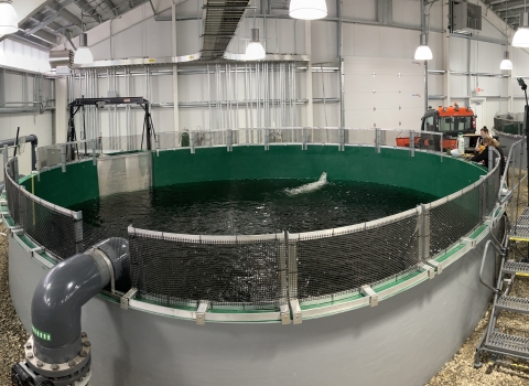
Leavenworth National Fish Hatchery is headquarters for the Leavenworth Fisheries Complex. When built in 1940, it was the largest fish hatchery in the world. Historically, the hatchery produced several species of trout and salmon; today, it produces primarily spring Chinook salmon along with coho salmon, in cooperation with Yakama Nation Fisheries.
The hatchery is also home to the Mid-Columbia Fish and Wildlife Conservation Office, a public boat launch, a Tribal fishing area, and over 5 miles of public trails.


