There’s something new drawing visitors — cyclists, runners and pedestrians — to the Ravenswood unit of the Don Edwards San Francisco Bay National Wildlife Refuge: The Flyway Trail and Viewing Area, which opened in October 2024.
As trails go, it might not seem like much: just a half-mile strip of pavement between the refuge and Bedwell Bayfront Park, the only city-owned open space within the city of Menlo Park. But as a connector, the new trail is a game changer.
The trail links to a footbridge that Meta (formerly Facebook) built two years ago across Interstate 84. The result is the first-ever walking path from congested East Palo Alto and the Belle Haven neighborhood of Menlo Park to the park and the refuge. “We’re literally bringing the bay to people’s footsteps,” says Miguel Marquez, park ranger at the San Francisco Bay National Wildlife Refuge Complex.
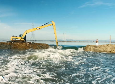
The trail also showcases a major effort to restore the bay and reduce area storm flooding. Trail users can see three different types of wetlands managed by the refuge, as it returns former industrial salt ponds to tidal flow.
Shared Pride
Enthusiasm for the project abounds.
“It was a really great collaboration,” says Ann Spainhower, refuge manager of San Francisco Bay Refuge. “It’s nice to be able to assist local governments with storm water management, so they can alleviate some flooding problems they’ve had in the past… But my favorite part is we’re opening this connection from the city to the refuge …. and putting up new interpretive signs. We’ve never had anything like that before.”
Menlo Park Mayor Cecilia Taylor adds her praise, calling the trail “an example of interagency cooperation and working together to get big things done.” She continues, “This Flyway Trail will benefit our current and future residents in Menlo Park, and nearby cities by creating a healthier environment through open space, better access for the public, and most importantly additional resiliency to our beautiful shoreline.”
The trail’s opening day — October 19, 2024 — had a festival feel, with guided walks, demos, games, and the refuge’s unveiling of colorful interpretive panels.
“There was tremendous turnout from the community,” says Miguelina Portorreal, public affairs specialist for the Service’s Pacific Southwest region. “More than 300 people came out. A lot of partners set up booths.”
Partners Weigh In
Staffing the booth for Nuestra Casa de East Palo Alto, a nonprofit that partners with the refuge and advocates for area Latino families, was Jennifer Adams, the group’s environmental justice senior program manager. The trail “is definitely going to be a huge benefit for the community,” she says.
“I love that [trail planners] gave thought to the community the trail is serving,” she adds. “Every sign they put up has a QR code that takes you to an interpretive sign fully in Spanish.”
Also at the trail opening was Martin Cooper, a volunteer with the nonprofit environmental group Save the Bay. Some green slopes the group is planting to provide wildlife habitat and reduce flood risk are visible from the Flyway Trail.
“You read about all these big construction projects to help with sea-level rise… and provide refuge and habitat for native species,” he says. “But people can’t really see what that means. With this trail, they have a viewing point to see what a horizontal levee looks like, how it will work to help with sea-level rise. It’s important to see that.”
Adams looks forward to using the trail on the next annual bay shore cleanup, on which Nuestra Casa partners with the refuge. “We’ll use that as an opportunity to tell people why restoring these places matter…. and why returning some ponds to wetlands may reduce community flooding.”


