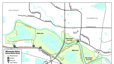
Trails located in west Bloomington and Shakopee, Minnesota at Minnesota Valley National Wildlife Refuge. Download this map to use on mapping apps like Avenza Maps, to navigate your location while on the refuge without internet or network connection.
Steps to set up on your mobile device directly on the Avenza app:
- Be connected to the internet on your mobile device
- Download the free Avenza Maps app available on iOS or Android devices
In the app, click Store, click search bar and select Keywords. Type "Minnesota Valley National Wildlife Refuge“
Select maps starting with “MNVNWR,” to have live-tracking digital trail maps of the refuge!
Note: The free version is limited to having three maps downloaded to the app at any one time.
If you would like to use this map for another live-tracking, mapping app you can download the PDF below.
Publication date
Type of document
Refuge Map
Facility
Program
FWS and DOI Region(s)


