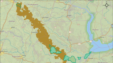
This map from the draft Land Protection Plan for Roanoke River National Wildlife Refuge and Environmental Assessment shows Alternative D in relation to the existing Roanoke River NWR Approved Acquisition Boundary and current Refuge Lands. The map also shows the location of Alternative D in relation to the Northampton, Halifax, Bertie, Martin and Washington County boundaries. For accessibility assistance, please contact the refuge at 252-794-3808.
Publication date
Type of document
Map
Facility

Program

FWS and DOI Region(s)