Location
States
ArizonaEcosystem
ForestIntroduction
The Tonto National Forest (TNF), managed by the U.S. Forest Service (USFS), lies primarily in Gila County of east-central Arizona and encompasses approximately 2.9 million acres of public land. The Forest offers various competing uses, such as recreation, wildlife habitat, watershed management, and livestock grazing. In the western U.S., seasonal livestock grazing on public lands is an important feature of ranching operations. The USFS allows grazing on specific allotments of TNF lands and sets out the terms and conditions for grazing (such as how many livestock can be grazed where and when) with permits or leases. More than 20,000 head of cattle graze TNF lands year-round across 104 different allotments.
Federal land managers and ranchers may struggle to collaboratively prepare for and manage drought. As public lands, national forests like the Tonto must be managed in congruence with the federal laws and regulations enacted to help protect their multiple uses and environmental quality. Livestock grazing is also subject to these conditions, which can make it challenging to satisfy the individual needs of a livestock operation while complying with regulatory requirements. Changes to grazing permits or proposed land management actions, including those that may aid in drought preparation, must be reviewed and approved through a process dictated by the National Environmental Policy Act (NEPA). This process can significantly lengthen the time between planning and implementing new management practices. To further complicate matters, drought can be difficult to prepare for due to its variability across space and time. As drought continues to increase in frequency and severity, streamlined planning is of high importance among public land managers and users.
In an effort to help address these challenges, the Gila County Cattle Growers Association, and University of Arizona researchers engaged USFS staff and TNF ranchers in a series of interactive workshops to discuss and improve drought planning on public lands. Insights from these workshops informed the development of a formal guide to co-developing drought preparation plans for livestock grazing on Southwestern national forests.
Key Issues Addressed
In 2002, the USFS instructed permittees to remove all livestock from TNF lands due to severe drought conditions, as indicated by an overall Standardized Precipitation Index (SPI) value for the forest of -2. However, the USFS drought monitoring does not account for differences in drought conditions and impacts across allotments. For some ranchers, working relationships with the USFS became tense as trust was lost. Evaluation of allotments on a case-by-case basis would have allowed for a more flexible response to drought that better suited the unique conditions of each allotment.
Following the backlash from ranchers in 2002, the USFS developed a drought policy for national forests in Arizona and New Mexico (Region 3) that would prompt drought assessments of individual livestock grazing allotments anytime the SPI value for the entire forest falls below -1 for the preceding 12-month period. While this policy directly acknowledged rancher frustrations and the need to individually evaluate grazing allotments, formal planning efforts between TNF and ranchers were needed to address drought planning in the unique context of public lands ranching operations in the Southwest. Without a formal drought preparation plan in place, management flexibility was limited as neither the USFS nor ranchers had previously considered how they would respond to such severe drought conditions. Had formal drought planning occurred previously, the parties could have outlined mutually-agreeable responses to different possible drought scenarios and started the approval procedures through the National Environmental Policy Act (NEPA) to solidify those responses as real options.
Project Goals
- Improve drought preparedness and response to future droughts by hosting interactive and collaborative workshops to brainstorm potential responses to different drought scenarios
- Produce a written guide to help TNF staff and livestock permittees navigate the co-development and implementation of strategic drought preparations
- Improve collaboration and increase trust between ranchers and TNF staff to sustain an effective and efficient working relationship
Project Highlights
Sprinkle Ranch Allotment: The Sprinkle Ranch Allotment is a hypothetical ranch characteristic of the Southwest used in the workshop and drought preparation guide to demonstrate how drought plans can be co-developed.
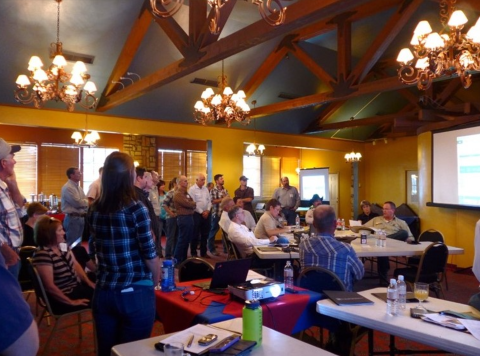
- Workshops:Three workshops enabled TNF staff and ranchers to begin building a more effective working relationship by collaboratively planning for drought and understanding the nuances of rancher needs and TNF regulatory requirements.
- Scenario Planning: Using scenarios, or realistic event(s) that provide the context for training activities or planning discussions, allowed agency staff and ranchers to evaluate the flexibility of the current drought management regime and explore potential preparations and responses for the future.
- Building Trust:Surveys conducted before and after the series of workshops revealed increased levels of trust between parties, highlighting the perceived value of relationship building through the workshops.
- Southwest Drought Planning Guide: Based on insight gained from the workshops, a drought preparation guide, “Guide to Co-Developing Drought Preparation Plans for Livestock Grazing on Southwest National Forests,” was designed to help the USFS and ranchers co-develop and implement long-term plans to improve drought preparation.
Lessons Learned
The project originally sought to increase drought preparedness in the TNF and develop a written document to improve and guide future collaboration between TNF staff and ranchers during drought planning efforts. Importantly, the workshops that led to the guide’s creation proved valuable as well. The first workshop took the form of an information session and left little room for engagement between TNF staff and ranchers. Realizing this was an ineffective approach, workshop facilitators adopted a more participatory approach in the second workshop by employing a scenario-based exercise using the hypothetical yet realistic Sprinkle Ranch example. The use of hypothetical scenario planning allowed for workshop attendees to identify strategies to mitigate drought impacts independent of the stress of a real-world drought situation. The collaboration and discussion during the scenario planning offered an opportunity to begin repairing what had previously been a challenging working relationship for both TNF staff and ranchers. In creating space for TNF staff and ranchers to converse openly, it set the tone for the third and final workshop which dove into the intricacies of NEPA administration.
Next Steps
- Researchers at the National Drought Mitigation Center (NDMC), in collaboration with the USDA Northwest Climate Hub, are currently working to create a similar drought preparation guide for federal land managers and livestock ranchers in the Pacific Northwest (PNW) region of the United States, where grazing on public lands is also a staple of ranching communities.
- The NDMC will interview individuals who have used the Southwest guide to inform guide revisions and determine guide usability and usefulness.
- To be relevant and usable for managers in the Northwest, the NDMC will also interview agency staff and ranchers in the PNW to characterize the unique context of public lands grazing and the nature of drought in the region.
- This will be incorporated into the update and expansion of the NDMC’s Managing Drought Risk on the Ranch resource, which currently focuses primarily on livestock operations on privately-owned land in the Great Plains and parts of the Southwestern U.S.
Funding Partner
National Oceanic and Atmospheric Administration (NOAA) Sectoral Application Research Program (grant #NA140AR4310242)
Resources
- Guide to Co-Developing Drought Preparation Plans for Livestock Grazing on Southwest National Forests
- University of Arizona Drought Dashboard: Drought and Grazing
- University of Arizona Drought Dashboard Tools
- The University of Arizona, Cooperative Extension
- Drought Scenario Planning Tool
- Tolleson, D.R. (2017). An Easy to Use System for Developing a Drought Management Contingency Plan. The University of Arizona Cooperative Extension (AZ1725)
- Tonto National Forest
Contacts
- Kelsey Landreville, Pima County Natural Resources, Parks and Recreation: kelsey.landreville@pima.gov
- Mitch McClaran, University of Arizona: mcclaran@email.arizona.edu
CART Lead Author
Madeline Goebel, Social Science Research Assistant, National Drought Mitigation Center: mgoebel10@unl.edu
Suggested Citation
Goebel, M., Hawkes-Landreville, K., and McClaran, M. (2022). “Collaborative Drought Planning for Livestock Grazing on Southwestern National Forests.” CCAST. Retrieved from https://www.fws.gov/project/collaborative-drought-planning-livestock-grazing.


