Location
States
OklahomaEcosystem
River/streamIntroduction
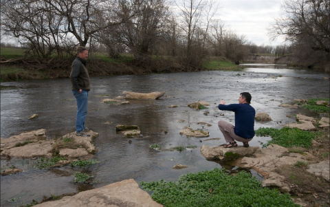
The Red River Basin (RRB) spans across the South Central United States, encompassing parts of five states from New Mexico to Louisiana. It covers approximately 27% of Oklahoma's territory (Kellogg, 2020). Numerous cities rely on its waters for commercial, municipal, and residential purposes, making these communities highly susceptible to hydrological shifts. Research from 2016 revealed that climate change climate change
Climate change includes both global warming driven by human-induced emissions of greenhouse gases and the resulting large-scale shifts in weather patterns. Though there have been previous periods of climatic change, since the mid-20th century humans have had an unprecedented impact on Earth's climate system and caused change on a global scale.
Learn more about climate change impacts within the basin are multifaceted, with the eastern region facing increased flooding risks and the western portion experiencing prolonged droughts (Kellogg et al., 2016). However, the findings did not provide a definitive outlook on whether the area will become drier or wetter overall.
Southwest Oklahoma endured a severe drought between 2010 and 2015, placing communities within the territories of the Chickasaw Nation (CN) and Choctaw Nation of Oklahoma (CNO) on the verge of water scarcity. Faced with the challenges posed by this drought and the uncertainties surrounding future climate impacts, the CN and CNO recognized the need for further assessment of future climate impacts on the water needs of their communities.
Both Nations collaborated with the South Central Climate Adaptation Science Center (SC CASC) and Aqua Strategies Inc. to refine the RiverWare water availability model to an applicable scale. This adjustment enabled analysis of the effects of permits for individual water usage, minor tributaries, streams, and community reservoirs on water availability. With this information, both Nations are better equipped to develop comprehensive water plans and support their communities as they explore alternative water sources, implement water conservation efforts, and protect local ecologies.
Key Issues Addressed
During the 2010-2015 drought, Oklahoma experienced one of its driest periods on record (NOAA, 2016). Climate models show that intense drought or flood periods in southern Oklahoma may intensify, making drought plans an important priority to reduce community water shortages, habitat loss for water-dependent species, and other negative impacts.
Research from 2016 explored the area’s hydrological shifts with the RiverWare tool, modeling the effects climate projections show for water runoff and availability in the region’s reservoirs (Kellogg et al., 2016). The 2016 RiverWare water availability model used multiple climate projection scenarios and Variable Infiltration Capacity (VIC) models to generate streamflow projections from precipitation and temperature inputs. This model gave flow estimates for the area, but it needed added details including anthropogenic impacts such as diversions, return flows, and legal water permit limits applicable for community drought planning and ecosystem monitoring (Kellogg, 2020).
Effective drought plans require comprehensive information about water supply and demand, water permits, and the groundwater and streams feeding important reservoirs. In addition to runoff and other hydrological processes, the RiverWare tool can model water rights, including legal water permits with different priority levels, river compacts, and complex reservoir operations. Municipalities across southeastern Oklahoma needed more complete models of the local permits and annual water allowances to understand their water shortage vulnerabilities.
In addition to limiting human water access, droughts affect local wildlife. Watershed estimates show broad water availability, but species like stream fish depend on daily or hourly water levels. This determines their ability to survive and reproduce (Kellogg, 2020). An ecologist from Oklahoma State University (OSU) saw the value of more detailed water availability models for understanding drought impacts on fish. Further examination of stream fish occurrence and habitat variability across wet and dry seasons was needed for a more holistic perspective on drought impacts.
Project Goals
- Refine the RiverWare water availability model scale to determine specific climate change impacts on the hydrology within the CNO and CN territories and include individual water permits.
- Identify the communities with future water vulnerabilities and assess the projected volume of water needed.
- Evaluate the impacts of the wet and dry cycle of the basin on flow-ecology relationships.
Project Highlights
Oka Holisso: The Chickasaw Nation and Choctaw Nation of Oklahoma collaborated on a comprehensive guide to water stewardship within their boundaries. The book includes research on policies, agreements, ecology, and water monitoring.
- Refining the RiverWare Model: Water experts from Aqua Strategies Inc. added the region’s legal water permits, detail on small tributaries, and complex reservoir operations to refine the existing water availability model. These additions give water managers a detailed view of the constraints and demands of different water sources, providing a more realistic view of the challenges they can expect in future droughts (Kellogg, 2020). This analysis shows where more water supply and infrastructure development are needed, especially in communities dependent on a single water source.
- Application of the RiverWare Model for Communities: Water availability projections for the CN and CNO territories can help address drought vulnerabilities before they become hazardous. With the updated data, the report from Aqua Strategies Inc. showed that half the region’s municipalities depend on water permits with decreased projected reliability (Kellogg, 2020). This helps growing cities prioritize gaining access to additional water sources as they anticipate heavier water demands in addition to decreased availability from some current water sources.
- Water Flow Affects Stream Fish Occurrence: Water flow metrics from refined area models were combined with fish survey records. This allows ecologists to understand how the presence of local stream fish species in the area changes with varying water availability across wet and dry seasons. Nearly 100 species were examined from the period of 1961 to 2010. Researchers found significant fish occurrence relationships with water flow metrics for 77 species and two seasonal differences relating to the dates of annual maximum and minimum water flows. The occurrence probability for ten species decreased significantly in dry seasons in relation to the date of the annual maximum flow (Kellogg, 2020).
Lessons Learned
The CN and CNO bring a holistic approach to water sustainability projects, which is reflected in the project’s wide focus on ecosystem impacts, water availability, and quality. Tribal perspectives prioritize the well-being of the next seven generations, leading to more sustainable planning. The CN and CNO help other partners understand the engagement and commitment of personnel and resources necessary to implement long-term projects.
Climate projections must accept uncertainty at all stages since they account for variables such as ongoing climate change, unpredictable natural phenomena, and future levels of human greenhouse gas emissions. Researchers and resource managers cannot assume one model is always accurate, but they can include multiple models in a study. Downscaling climate models takes time and resources, which means the models must be carefully selected. This study incorporated two downscaling methods, three Global Climate Models (GCMs), and three Representative Concentration Pathways (RCPs). The wide possibility range accounts for variations in temperature and precipitation patterns, allowing for more comprehensive drought plans.
Effective and broad-reaching climate change solutions require contributions from multiple disciplines. Ecologists, hydrologists, biologists, and engineers worked together on this project. Communicating across disciplines can be difficult, so it is important to express the full scope of the project to everyone involved. For example, the hydrologists’ data showed monthly water availability, but the ecologists needed model output for daily water levels. Developing a clear communication protocol from the beginning can help alleviate confusion from different information needs across research and planning processes.
Next Steps
- Support communities as they address water vulnerability. The CN and CNO will provide funds to the at-risk communities identified in this report, helping cities explore additional water sources and conservation efforts.
- Share methods to enhance drought planning in other regions. Through a partnership with the South Central Climate Adaptation Science Center, the study’s methods and findings will be available to a broader audience.
- Increase interstate collaboration to protect water resources. Oklahoma and Texas both draw water from the RRB, so awareness of drought vulnerability contributes to greater protection efforts despite past water rights conflicts.
Funding Partners
Resources
- Kellogg, W. et al. (2016). “Impacts of Climate Change on Flows in the Red River Basin.” South Central Climate Science Center.
- Kellogg, W. (2020). “Evaluation of sustainable water availability in drought prone watersheds in Southeastern Oklahoma.” South Central Climate Science Center.
- National Oceanic and Atmospheric Administration. (2016). “Monthly Drought Report for Annual 2015.”
- Final Report: Evaluation of sustainable water availability in drought prone watersheds in Southeast Oklahoma
- Final Report: Impacts of Climate Change on Water Flows in the Red River Basin
Contacts
Barney Austin, Aqua Strategies Inc.: baustin@aquastrategies.com
CART Lead Author
- Haylee Kraker, Case Study Author, CART
- Jessica Zimmerman, Case Study Author, CART
Suggested Citation
Kraker, H., J., Zimmerman, J., & Austin, B.(2024). “Evaluation of Sustainable Water Availability in Drought Prone Watersheds in Southeastern Oklahoma.” CART. Retrieved from https://www.fws.gov/project/evaluation-sustainable-water-availability-drought-prone-watersheds.


