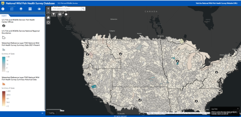
National Wild Fish Health Survey Mapper
The National Wild Fish Health Survey provides information on the presence or absence of aquatic animal pathogens in wild fish populations to tribes, state and federal fisheries managers, the aquaculture industry, conservation groups, researchers, and the public. This information helps to better manage both hatchery and wild fish populations.
The survey is conducted by the U.S. Fish and Wildlife Service’s Fish Health Centers and the information is used to help biologists and fisheries managers decide where and how to manage aquatic animals and to model for future pathogen occurrences. This data can help to establish safe zones and areas where movement of aquatic animals can take place without endangering the health of wild fish populations.
The data from the Survey is available to explore in a GIS Mapper that can be used to:
Track fish movement in wild environments.
Assess the risk of pathogen spread.
Understand the distribution of pathogens in the environment.
Inform modeling decisions
Help inform conservation decisions.
Select the best locations to source broodfish.
Identify what fish are susceptible to pathogens and where they can be found.
Launch the National Wild Fish Health Survey Database Mapper
Open mapper by clicking on the link below (best viewed by maximizing your browser window):
National Wild Fish Health Survey Mapper
Review Mapper Case Studies that Explore Data, Export Data to .CSV, and Create Maps:
Description of Layers
U.S. Fish and Wildlife Service Regional Management Boundaries
Watershed Reference Layer FWS National Wild Fish Health Survey Summary Data 2021-Present – This feature layer contains all the National Wild Fish Health survey data from 2021-present. This feature layer is updated on a monthly basis. Please see the ArcGIS Online item’s metadata (URL) for more information.
Watershed Reference Layer FWS National Wild Fish Health Survey Summary Historical Data - This feature layer contains all the National Wild Fish Health survey data from 1996-2020. Please see the ArcGIS Online item’s metadata (URL) for more information.
Description of Filters
HUC 8 Watersheds Layer - Watersheds are delineated by USGS using a nationwide system based on surface hydrologic features and reference by a hierarchical hydrologic unit code (HUC).
List of U.S. States by HUC 8 Watershed
List of Pathogens by HUC 8 Watershed
For regionally specific questions contact the staff at our Fish Health Centers.
California-Nevada Fish Health Center
Ken Nichols CANVFishHealthCenter@fws.gov
Bozeman Fish Health Center
Rick Cordes rick_cordes@fws.gov
Lacey Hopper lacey_hopper@fws.gov
Lamar Fish Health Center
William Quartz william_quartz@fws.gov
Dexter Fish Health Center, SNARRC Fish Health Center
Jason Woodland jason_woodland@fws.gov
La Crosse Fish Health Center
Kenneth Phillips kenneth_phillips@fws.gov
Rebekah McCann rebekah_mccann@fws.gov
Pacific Region Fish Health Program
Andrew Goodwin, andrew_goodwin@fws.gov
Warm Springs Fish Health Center
Devin Chappell devin_chappell@fws.gov


