Location
States
South CarolinaEcosystem
CoastalIntroduction
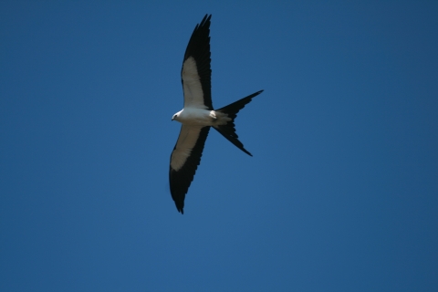
The U.S. Fish and Wildlife Service’s (USFWS) Waccamaw National Wildlife Refuge (NWR) protects 38,000 acres of freshwater forested wetlands, long-leaf pine forests, and historic rice fields near the northeastern coast of South Carolina. The refuge provides habitat to more than 400 species of animals, including endangered species like the swallow-tailed kite (Elanoides forficatus) (USFWS, 2008).
Like many coastal landscapes, Waccamaw NWR has been impacted by climate change climate change
Climate change includes both global warming driven by human-induced emissions of greenhouse gases and the resulting large-scale shifts in weather patterns. Though there have been previous periods of climatic change, since the mid-20th century humans have had an unprecedented impact on Earth's climate system and caused change on a global scale.
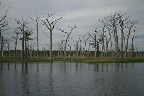
Learn more about climate change . As sea levels rise, ocean water seeps into freshwater systems near the refuge through a process known as saltwater intrusion. Freshwater forests at the refuge are dying due to the increased water salinity. Within the next 50 years, significant portions of forested wetlands on the refuge are projected to transition to brackish marsh.
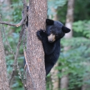
Swallow-tailed kites are a state endangered bird species in South Carolina that nest in the trees of these freshwater forests. These habitat changes will diminish their nesting grounds, causing a decline in their population. Black bears (Ursus americanus) at the refuge will also be affected. Their populations are highly fragmented due to urbanization in the area. Saltwater intrusion will push their habitats closer to residential areas and highways.
Staff wanted to address these concerns by acquiring additional land tracts with freshwater forests that would not be impacted by saltwater intrusion in the near future. Each refuge has an acquisition boundary of approximately 7,000 acres, or a pre-approved area in which staff are authorized to purchase or lease land. Land tracts within Waccamaw NWR’s acquisition boundary were urbanized, making them unusable for conservation. Staff were also unable to expand the acquisition boundary. Left with no other options, refuge staff created a novel land acquisition technique known as Minor Boundary Modification. It allows refuges to remove unsuitable land tracts from their acquisition boundary and replace it with land parcels appropriate for conservation. By strategically acquiring land, Waccamaw NWR is able to adapt to climate change impacts that cannot be addressed through restoration or mitigation efforts.
By pairing strategic acquisitions with the nature-based solution of assisted wetland migration, habitat connectivity is ensured and human well-being is supported by intentionally using the land to meet community needs. The USFWS has identified nature-based solutions as a key strategy in the USFWS Climate Change Action Program to unify its climate response in accordance with the Department of the Interior’s Nature Based Solutions Policy.
Key Issues Addressed
Waccamaw NWR and its surrounding areas have the highest density of nesting swallow-tailed kites in South Carolina (USFWS, 2008). Swallow-tailed kites also nest in large groups, limiting their nesting habitat to densely vegetated freshwater forests. Black bears also inhabit these forested wetlands. Their population is highly fragmented, or broken up into smaller disconnected areas, due the development of highways and urban areas in coastal South Carolina (Still & Butfiloski, 2015). As saltwater intrusion causes tidal freshwater forests to transition to brackish marsh, swallow-tailed kite nesting grounds and black bear habitat will decrease.
Acquiring additional land with forested wetlands that will not be impacted by near-term climate change could alleviate these problems. Refuges can expand their territory by purchasing or leasing land that lies within their acquisition boundary. A significant portion of land within Waccamaw NWR’s acquisition boundary has been developed into residential areas and public works facilities, making it unsuitable for conservation purposes. When refuges cannot acquire land within their acquisition boundary, they may expand it by up to 10% of the current size of their refuge without approval from headquarters, through a process known as minor boundary expansion. Once a refuge has reached that limit, staff can apply for a major boundary expansion, which requires environmental assessments, public comment periods, and approval from headquarters.
Waccamaw NWR staff executed a minor expansion in 2001. They began the application process for a major expansion in 2008 with minimal forward progression (USFWS & USGS, 2023). At the same time, land tracts near the refuge were being purchased by developers rapidly, increasing the urgency to find a way to acquire land.
Project Goals
- Create a technique different from the minor and major boundary expansion processes to acquire and protect forested wetlands that will not be affected by saltwater intrusion in the near future.
- Increase habitat for native wildlife including swallow-tailed kites and black bears through land acquisition and protection.
Project Highlights
Following Suit: Since its creation, another refuge, Bayou Sauvage NWR, has used Minor Boundary Modification to acquire more land for conservation.
- Creating New Techniques for Land Acquisition: In response to the limitations of the minor and major boundary expansion processes, refuge staff created Minor Boundary Modification, a process that allows refuges to eliminate land that has not been acquired from their acquisition boundary and replace it with parcels equal to or less than the size of the tracts removed. Refuges may use this technique to alter their acquisition boundary without fulfilling the requirements of the major expansion process. In 2019, Waccamaw NWR staff used Minor Boundary Modification to simultaneously remove 6,849 acres and add 6,638 acres to their acquisition boundary.
- Strategic Land Acquisition: Refuge staff collaborated with The Nature Conservancy, American Rivers, and the South Atlantic Landscape Conservation Cooperative to develop a Landscape Conservation Design which uses climate models that helped identify parcels of freshwater forested wetlands that should remain unaffected by near-term saltwater intrusion. Forested wetlands made up over 1,600 acres of the land added to Waccamaw NWR’s acquisition boundary. The tracts will serve as federally protected nesting habitat for swallow-tailed kites.
- Acquiring Land for Black Bears: In 2019, refuge staff used Minor Boundary Modification to add Carver’s Bay, a 2,110-acre Carolina Bay, to Waccamaw’s acquisition boundary. The bay is considered to be one of the most important black bear conservation areas throughout the state (USFWS, 2019). In 2023, The Nature Conservancy transferred ownership of the property to Waccamaw NWR.
Lessons Learned
As climate change continues to impact ecosystem function, management techniques such as strategic land acquisition and nature-based solutions will become increasingly useful tools for adaptation. Resisting saltwater intrusion by employing restoration and prevention efforts would have delayed the inevitable at Waccamaw NWR. In shifting toward a strategy of land acquisition, staff increased the amount of forested wetlands on the refuge by over 1,600 acres.
The process of creating the Minor Boundary Modification technique took one year. During this time, high-priority parcels were at risk of being bought by other entities. To ensure these land tracts could become part of Waccamaw NWR, partners like The Nature Conservancy, Ducks Unlimited, and the Open Space Institute purchased the parcels. This gave refuge staff the time necessary to finish the Minor Boundary Modification technique proposal and receive approval. After modifying the acquisition boundary, partners transferred ownership of various land tracts to Waccamaw NWR.
Refuge staff used Minor Boundary Modification as an opportunity to connect with the local Gullah Geechee community. The Gullah Geechee people are descendants of the Africans enslaved on plantations from the coasts of North Carolina to Florida. In 2019, refuge staff added Hasty Point Plantation, a 750-acre historic rice plantation and an important cultural resource for the Gullah Geechee, to their acquisition boundary. The previous property manager transferred ownership of the plantation to Waccamaw NWR in 2020. Refuge staff hired a cultural coordinator to connect with community leaders and better understand their needs. After three years of repairs and maintenance, Waccamaw NWR opened the site for public access in 2023 (Khoriaty, 2023).
Next Steps
The U.S. Fish and Wildlife Service will update its realty manual in summer 2024 to include Minor Boundary Modification as a new strategy for land acquisition. This will notify and encourage refuge managers to consider following Waccamaw NWR’s example if they are facing similar issues. Ultimately this action will allow for more land to be purchased for conservation and give refuges another tool to address the effects of climate change.
Resources
- Knoriaty. (2023). “Waccamaw Wildlife Refuge expands to allow more exploring in Georgetown County.”
- Still & Butfiloski. (2005). “Black Bear Ursus americanus.” Supplemental Volume: Species of Conservation Concern.
- USFWS. (2008). “Waccamaw National Wildlife Refuge Comprehensive Conservation Plan.”
- USFWS and USGS. (2023). “The State of Waccamaw NWR's Coastal Wetlands.”
- USFWS. (2019). “Decision Report Proposed Minor Boundary Modification of Waccamaw National Wildlife Refuge.”
- USFWS Climate Change Action Program
- Department of the Interior’s Nature Based Solutions Policy
Contact
- Marshall (Craig) Sasser, Refuge Manager, USFWS: marshall_sasser@fws.gov
CART Lead Author
- Belen Delgado, Case Study Writer, USFWS Maintenance and Infrastructure Fellows Program
Suggested Citation
Delgado, B. and Sasser, M.C. (2024). “Land Acquisition to Address Saltwater Intrusion on Waccamaw National Wildlife Refuge.” CART. Retrieved from https://www.fws.gov/project/nature-based-solutions-land-acquisition-address-saltwater-intrusion.

