Location


States
MarylandEcosystem
WetlandIntroduction
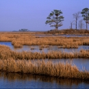
Blackwater National Wildlife Refuge (the refuge) is a tidal salt marsh salt marsh
Salt marshes are found in tidal areas near the coast, where freshwater mixes with saltwater.
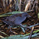
Learn more about salt marsh and forested wetland of “International Importance” that spans over 33,000 acres in the Chesapeake Bay system. The refuge provides habitat for many species of plants and animals, especially rapidly disappearing migratory marsh birds, the saltmarsh sparrow (Ammodramus caudacutus) and eastern black rail (Laterallus jamaicensis jamaicensis). The tidal marshes hold rich stories of the Nanticoke Native American villages and are part of the Harriet Tubman Underground Railroad National Monument. The people of lower Dorchester County rely on the marshes not only for the ecotourism and recreational benefits, but also as protection, buffering the community from severe weather events.
Over the past century, global sea levels have risen approximately six inches (Cole 2008). However, the local Chesapeake sea level has risen by a foot, exacerbated by land subsidence and erosion. Since 1938, the refuge has lost over 5,000 acres of marsh land due to rising sea levels, erosion, subsidence, and damage from an introduced invasive species invasive species
An invasive species is any plant or animal that has spread or been introduced into a new area where they are, or could, cause harm to the environment, economy, or human, animal, or plant health. Their unwelcome presence can destroy ecosystems and cost millions of dollars.
Learn more about invasive species , nutria (Myocastor coypus), a large amphibious rodent. Scientists predict the water levels of Chesapeake Bay to rise an additional two feet by 2100. The tidal marshes in Dorchester County cannot maintain elevation at the rate needed to keep pace with the Chesapeake’s rising sea levels.
To implement changes necessary to protect the marsh, the refuge worked with the Maryland Department of Natural Resources, The Conservation Fund, and Audubon Maryland-D.C. to develop a sea level rise adaptation plan in 2013, Blackwater 2100. By prioritizing wetland restoration, managing predicted marsh migration, and eradicating nutria, the refuge has increased the resiliency of remaining refuge wetlands and helped maintain wildlife habitats and important ecosystem services. The integration of nature-based solutions, such as facilitating marsh migration, provides human well-being and biodiversity benefits. The USFWS has identified nature-based solutions as a key strategy in the USFWS Climate Change Action Program to unify its climate response in accordance with the Department of the Interior’s Nature Based Solutions Policy.
Key Issues Addressed
Nutria were introduced to the Chesapeake area for the fur trade in the 1940s. Nutria can eat up to 25% of their weight in plant material every day, devastating important native plants that hold marsh soils in place. Their excessive herbivory has destroyed 7,000 acres of marshlands in the Chesapeake Bay (Pepper et al. 2018).
Sea level rise and subsidence are submerging tidal marshes and driving the loss of valuable fish and wildlife habitat, as well as important ecosystem services for the community. Climate change and increasingly frequent and severe weather events have led the people of Dorchester County to experience more frequent and severe flooding and storm surge. Flooding makes roads more susceptible to cracking and potholes, making road maintenance and stormwater management challenging. The moisture affects the soil and causes concrete and wood structures to deteriorate, creating mildew and other health risks.The health of the marsh directly affects the livelihood of the people in Dorchester County.
Rising sea levels cause marsh fragmentation and subsidence through erosion and depletion of stabilizing vegetation. Sediment deposition and root formation from vegetation help build marsh elevation. However, sea level rise and saltwater intrusion threaten native plants that are less tolerant to salinity conversion and increased flooding events. Additionally, tidal marsh subsidence drives the loss of valuable fish and wildlife habitat. As native grasses and trees are weakened, the invasive phragmites (Phragmites australis)establishes more populations. While phragmites help manage erosion and keep sediment in the marsh, it does not provide adequate habitat for many native species of birds and other animals.
Past conservation plans for the refuge called for restoration to historic conditions; however, this does not account for the current scale of sea level rise. Without planning for these changes, managers may not be prepared to address potential impacts or can waste resources on managing infeasible outcomes. It is imperative to incorporate future changing environments during planning efforts.
Project Goals
- Use tidal marsh modeling and ecological transformations to build marshland structure structure
Something temporarily or permanently constructed, built, or placed; and constructed of natural or manufactured parts including, but not limited to, a building, shed, cabin, porch, bridge, walkway, stair steps, sign, landing, platform, dock, rack, fence, telecommunication device, antennae, fish cleaning table, satellite dish/mount, or well head.
Learn more about structure and create new tidal marsh habitat - Use Congress-provided funding to eradicate nutria on the entire peninsula in partnership with state and federal agencies and public and private landowners
- Ensure future planning considers changing coastal conditions to benefit both the people and wildlife of the Chesapeake Bay
Project Highlights
Victory Over Nutria: On September 16, 2022 Maryland was declared free from nutria. The last known nutria capture was in May 2015. Collaboration among federal and state agencies and over 700 landowners made the eradication of nutria possible.
- Predictive Modeling: The project team used a forecasting tool, the Sea Level Affecting Marshes Model, to study the effects of sea level rise on marsh habitats under predicted relative sea level rise scenarios. Areas associated with salt marsh birds were used to create a habitat suitability model. Habitat suitability and factors such as land uses, existing or planned development, agricultural ditches, and flow accumulation were used to map marsh suitability areas. Suitability modeling and the sea level rise model identified the state of current resilient marsh areas, locations for marsh establishment in the future, and current marsh areas of high value to salt marsh birds.
- Thin-Layer Placement: This project was the first thin-layer placement in the Chesapeake Bay. Using dredge material from the Blackwater River, the refuge and partners sprayed 26,000 cu ft of sediment over 40 acres. The deposition of sediment increased marsh elevation in some areas by 3-6 inches. Increased marsh elevation creates productive root zones, maximizes plant productivity, and increases the odds for building marsh elevation in the future. The following year, refuge staff observed significant regrowth of native vegetation in the area. A University of Delaware bird survey showed all birds previously there had returned after the thin-layer placement. Rebuilding marsh elevation leads to an increase in buffering potential in the tidal zone.
- Collaborative Nutria Removal: Congress passed the Nutria Eradication and Control Act in 2003. With the help of public and private landowners, the project team has eliminated nutria from over 250,000 acres of wetlands on the peninsula. Wildlife surveys, along with trapping and tracking with detector dogs, helped to find and remove the nutria from the area. The last known nutria was trapped in 2015. The area was declared nutria free in September 2022.
Lessons Learned
The Blackwater 2100 plan forced refuge staff to think proactively: which marshes are most vulnerable to sea level rise and which are most resilient? Where will marshes be created on low-lying uplands due to marsh transgression? Predictive modeling takes into account local scale dynamics, creating a more refined goal and reducing many uncertainties. For example, the refuge has used this plan to help evaluate and prioritize potential land acquisition. Developing a sea-level rise adaptation plan to help understand where marshes were most vulnerable and where they were forming on the landscape due to sea level rise was a paradigm shift for refuge management work. This shift has allowed for more effective and beneficial restoration in previously unconsidered areas.
Despite management efforts, phragmites continues to outcompete native plants in many areas. The refuge has prioritized preventing the establishment of new phragmites populations over eradicating well-established stands.
A strong scientific foundation has been essential to this entire effort. New technology and techniques for removing nutria were developed through the coordinated effort of state and federal agencies and public and private landowners. Moreover, high quality research by scientific partners has been critical in reducing uncertainty and guiding decision making. The refuge continues to work with USGS, George Washington University, Virginia Institute of Marine Science and others to evaluate projects and improve their strategies.
Next Steps
- Given the success of phragmite in the ecosystem, the refuge will evaluate the consequences of accepting phragmites using the Resist- Accept-Direct decision-making tool especially for threatened marsh species. Further, the refuge will study the effect of salt on the soil to deter establishment of phragmites populations
- Determine long-term outcomes of thin layer placement projects
Funding Partners
- The Conservation Fund
- Hurricane Sandy Supplemental Bill
Resources
- September 2024 Case Study Handout
- Pepper et al. 2018 “Chesapeake Bay Nutria Eradication Project:2017 Update” Proceedings of the Vertebrate Pest Conference 311-316
- USFWS Resist-Accept-Direct Framework
Cole, Wanda Diane. (2008). “Sea level rise: Technical Guidance for Dorchester County”
Contact
Matt Whitbeck, Supervisory Wildlife Biologist, USFWS: matt_whitbeck@fws.gov
CART Lead Author
Lyric Buxton, Case Study Writer, USFWS Maintenance and Infrastructure Fellows Program
Suggested Citation
Buxton, L. (2024). “Marsh Migration and Thin-Layer Placement on Blackwater National Wildlife Refuge.” CART. Retrieved from https://www.fws.gov/project/nature-based-solutions-marsh-migration


