Location


States
New MexicoEcosystem
Desert, PrairieIntroduction
New Mexico’s average annual temperature has increased by 2.5℉ since 1980, and the Southwest region is experiencing the driest 22-year period in over a thousand years (Williams et al., 2022). Most of the precipitation in New Mexico arrives during the North American Monsoon Season, from June to September. However, the frequency, timing, and amount of precipitation is highly variable, and can include high intensity and short duration rainfall. Many factors, including drought, heavy livestock grazing, and mono-crop agriculture, have decreased the infiltration rate of the coarse-loamy soils prevalent in Northern New Mexico. When infiltration rates are low, the high-intensity monsoonal rains erode soil as it runs downhill, and precipitation critical for arid ranches is lost to evaporation.
Erosion from high intensity rainfall has removed topsoils rich in soil organic matter, important for soil water storage and plant growth. The loss of topsoil has reduced plant growth, further lowering soil organic matter (Quintana et al., 2023; Reyes, 2015). With funding from the New Mexico Healthy Soils Program, the owners of C-B Ranch and Esquibel Ranch are using keyline design to increase infiltration and restore vegetation on their properties. Australian rancher P.A. Yeoman developed keyline design in 1945 to control precipitation runoff on his rangeland. Keyline design uses the natural ridges and contours of a property’s topography to slow, spread, and sink rainwater (Thornbro, 2023; Feineigle, 2013).
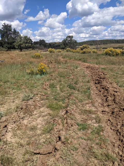
Two keyline design features are swales and rip lines. Swales are trenches dug along the contour lines of the landscape that have a berm, or higher wall of soil, on the downhill side of the swale. Swales slow and spread water to dry areas, with the berm acting as a steering bank to control surges caused by heavy precipitation. Thin and shallow rip lines are dug just above swales to collect precipitation, which allows water to infiltrate into the soil reducing runoff and soil erosion during heavy precipitation events. The ranches share the tools necessary to implement keyline design, including the technology required to map contour lines. In the dry climate of northern New Mexico, keyline design and treatment methods require at least five years of ongoing management, including maintaining swales and creating deeper rip lines, to see measurable increases in vegetation and soil organic matter.
Key Issues Addressed
The soils present in both ranches include sandy, clay, and loamy soils (NCSS, 2024). The sandy soils have become hydrophobic due to the region's dry conditions, while the clay soils are compacted from past livestock grazing on both ranches. Loamy soils contain silt and very fine sand particles that are easily transported by heavy rainfall, and are consequently susceptible to erosion (O’Geen et al., 2006). Due to these soil conditions, during high intensity rainfall, as much as 80% of the rain that lands on C-B Ranch runs down the 3% slope of the pasture instead of soaking into the soil, causing soil erosion. The erosion of the topsoils rich in organic matter has resulted in the loss of native vegetation, which in turn, results in even less organic matter, and soils that no longer support the growth of native grasses. According to landowners, the land productivity on C-B Ranch is 33% of its potential, and most of the grassland is void of cool season grasses.
Since its development, Keyline Design has been used in several landscapes to better manage water and to restore vegetation, including forests, vineyards, and wetlands (Doleman et al., n.d.). While Keyline Design has been implemented in different landscapes, most have been located in Australia, and there is a need for more understanding on how Keyline Design works on grasslands, such as on C-B Ranch, and with various soil types, including coarse-loamy soils. Another consequence of keyline design being developed in Australia is that many ranchers in the United States are unaware of how beneficial and easy implementing keyline design can be.
Ranch managers first need knowledge of the landscape’s contours and natural features before they can plow swales and riplines to increase water infiltration and decrease soil erosion. While topographic maps provide a visualization of an area’s contour lines at a coarse scale, planning where and how to plow swales and riplines requires a finely-detailed site map. Ranch managers may be unaware of the specialized tools and technologies required to create finer detailed maps. To implement keyline design, ranch managers also need to understand the process of how to transition from planned swales and riplines on a map to plowing on the ranch, including how to plan out paths for plows and which plows are needed.
Project Goals
- Plan the flow of water by mapping contour lines. Implement swales and rip lines accordingly to slow and spread water for increased filtration in desired locations
- Use plows to create swales and riplines, to encourage growth of native and seeded vegetation, and increase soil organic matter content
- Host workshops to share knowledge on the importance and ease of keyline design principles, and on the technologies required to implement keyline design. During workshops, teach ranch managers how to create detailed maps, and the considerations necessary while planning swale and riplines
Project Highlights
Soil from top down: Each successive year of plowing swales and rip lines stimulates plant roots and organic matter to spread deeper into the soil, building soil from the top down over time.
Visualizing the Landscape: Managers used a consumer drone to take hundreds of photos of the project areas on each ranch. Managers then used GIS software to both convert the images to orthophotos (images with a uniform scale), and to assign elevation values to each pixel in the photos. Because the resulting orthophotos had a uniform scale, managers were able to combine the images together to create a finely detailed orthophoto map of the project areas. This process allowed managers to visualize the 3% slope of the downhill-facing landscape, increasing their working knowledge of the land. Managers decided to place the swales and rip lines 100 feet apart, to leave plenty of room to operate plows and add future swales and rip lines, and to minimize the amount of disturbance to native vegetation. Managers placed swales and riplines slightly off contour to direct water to drier areas of the landscape. In contrast, placing swales and riplines directly on contour can spread water evenly across the landscape.
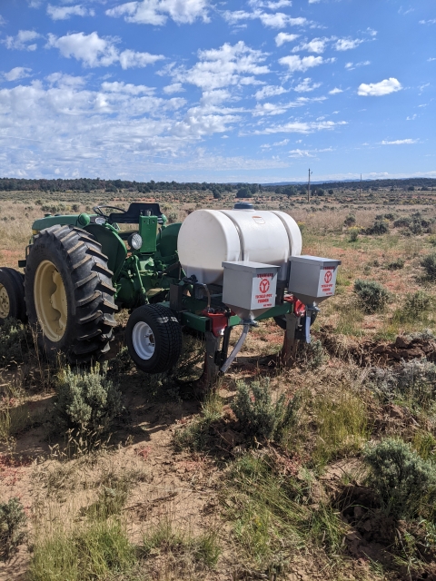
Implementing the Design: Managers rented a high-capacity laser level to delineate the contour lines along the ground, and marked the path for the plows with pin flags. Managers passed over the contour lines twice with a single moldboard plow to create deeper swales. Managers then installed two 15-inch-deep rip lines with a specialized plow, a two-shank Yeoman's plow, fitted with equipment to evenly disperse bioreactor compost tea and cover crop seed mix. Managers hand seeded the swales using the same seed mix.
Tools Specialized for Soil: A small team ofmanagers installed swales using a single moldboard plow, which features a curved plate designed to lift and turn soil upside down (Carter and Mckeyes, 2005). The plow created a single line with minimal disturbance to the surrounding area to capture water. Managers created rip lines using the Yeoman's plow, created specifically for keyline design. At the bottom of each Yeoman's plow shank is a wide boot, which fractures and aerates subsoil. The Yeoman's thinner shank is designed to minimally disturb soil surfaces while reaching greater soil depths.
Knowledge Sharing: Together, the two ranches hosted a workshop to meet the education and outreach requirements of the New Mexico Healthy Soil Program and to contribute a field day for Seeding Regenerative Agriculture. At the workshop, the ranches shared a handout on the process of creating a finely detailed map of contour lines, including a guide of how to use free processing and mapping software, and where locals could obtain a consumer drone and laser level. Then, workshop participants used the laser level to lay out swales and rip lines. Despite the terrain being muddy that morning, over 20 participants participated in the workshop.
Lessons Learned
The seeded cover crops have begun to grow in the rip lines on both ranches in the first year after management implemented keyline design. The vegetative growth indicates keyline design can be a tool for restoration on grasslands and pastures in New Mexico. Even so, keyline design is intended to nudge ecosystems in the direction of restoring soil building processes, and will not produce changes overnight. The ranchers are patient and monitor swales and rip lines to see when maintenance (such as replowing rip lines if the subsurface water infiltration pathways become compacted) needs to be performed. The use of a drone over the swales and rip lines can be an efficient method to monitor changes in vegetative growth and soil conditions. To determine if the swales and rip lines are spreading precipitation efficiently and allowing water to soak into the soil, the ranchers observe the project area while it is raining. Observing where precipitation initially lands, and noting where it ultimately ends up, can teach landowners how to modify the swales and rip lines on their property.
The efficiency and efficacy of plowing swales and rip lines largely depends on how wet the soil is. In September, the dry and hard subsurface soil impeded plowing by the small tractor. Plowing when the soil surface is too muddy can also be challenging, so finding the optimal time to plow land between the two extremes is important.
While timing is important for the efficiency of plowing, the equipment used is critical for the success of the swales and rip lines. For example, soil clods can prevent contact between seeds and the soil in rip lines. A plow attachment, such as a roller or cultipacker, can be attached to the Yeoman's plow to break up clods prior to seeding.
The estimated project cost was $10,000, but there are ways to reduce the cost to ranchers. Rancher managers benefited from connecting with one another who own the tractors, plows, and mapping/survey technologies required or to those who know of funding sources. Management of C-B Ranch and Esquibel Ranch were able to implement keyline design with help from the New Mexico Healthy Soil Program and Seeding Regenerative Agriculture, and by sharing equipment and knowledge. The ranchers came together to be more resourceful and find the necessary equipment, including the consumer drone, and high capacity laser level.
Next Steps
- In the spring of 2024, reseed areas with perennial native grasses and forbs to replace annuals that were browsed by deer and elk
- Continue to plow deeper into the soil every year or other year, for five years, to build soil and increase water infiltration
- Expand project in C-B Ranch to another 40 acres in spring of 2024
- Keep observing project area to determine how much maintenance swales and rip lines require, and to see if water is flowing to dry ridges and soaking into the soil
- Hold more workshops to keep sharing the techniques and restoration possibilities of keyline design
Funding Partners
Resources
- Alexander and Rhodes. (1999). “Recreation, ecological impacts.” Encyclopedia of Environmental Science 358: 506-508.
- Carter and Mckeyes. (2005). “Cultivation and Tillage”. Encyclopedia of soils in the Environment 356-361.
- Doleman et al. (n.d.). “Keyline Design.” California AG Water Stewardship Initiative.
- Feineigle, M. (2013). “Before permaculture: keyline planning and cultivation.” Permaculture Research Institute.
- Kogut, P. (2020). “Monoculture farming in agriculture industry.” EOS Data Analytics.
- National Cooperative Soil Survey. (2024). “Primary characterization data for Rio Arriba, New Mexico.” United States Department of Agriculture.
- O’Geen et al. (2006). “Erodibility of agricultural soils with examples in Lake and Mendocino counties”. Publication 8194; University of California Division of Agriculture and Natural Resources.
- Quintana et al. (2023). “Drought differently destabilizes soil structure in a chronosequence of abandoned agricultural lands.” Catena 222: 106871.
- Reyes, S. (2015). “How soil and carbon are related.” Permaculture Research Institute.
- Thornboro, H. (2023). “What is a permaculture keyline design?” Redemption Permaculture.
- Williams et al. (2022). “Rapid intensification of the emerging southwestern North American megadrought in 2020-2021.” Nature Climate Change 12: 232-234.
Contacts
- Craig Conley, C-B Ranch: landhealth1@gmail.com
- Lucas Esquibel, Esquibel Ranch: golucasplus@gmail.com
CART Lead Author
Jackelyn Alessi, Case Study Author, Drought Learning Network (DLN)
Suggested Citation
Alessi, J.,R. (2024). “Restoring Rangelands in Northern New Mexico with Keyline Design.” CART. Retrieved from https://www.fws.gov/project/nature-based-solutions-restoring-rangelands-keyline-design.


