
Location


States
ArizonaEcosystem
DesertIntroduction
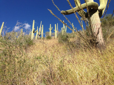
At Saguaro National Park (SNP) in Arizona, buffelgrass (Pennisetum ciliare) invasion is threatening biodiversity and iconic landscapes. Buffelgrass, a warm-season perennial species from Africa and Eurasia, is outcompeting native plants and increasing fire frequency, severity, and extent in the Sonoran desert. Herbicide is needed to effectively control buffelgrass, but it works best when applied to plants that are photosynthetically active (at least 50% green). In this project, researchers developed remote sensing methods that can help inform treatment of buffelgrass through landscape-scale monitoring and detection.
Buffelgrass was introduced intentionally to the southwestern United States in the first half of the 20th century because it is drought-tolerant. It was planted for erosion control and forage for livestock. Buffelgrass plants produce many seeds that can be transported by wind, water, wildlife, and people. Large, thick patches of buffelgrass can establish on both disturbed and undisturbed sites.
Key Issues Addressed
In SNP, buffelgrass has spread to cover approximately 2,000 acres. Park managers work aggressively to constrain its spread because of its potential to destroy cacti and the habitat of other native organisms. Buffelgrass greenness changes quickly and varies across the landscape. The widespread nature of the invasion coupled with rugged and remote terrain makes monitoring and treating buffelgrass throughout the park very difficult. Herbicide treatments must be applied by ground crews or helicopter. Knowing where buffelgrass is and when it is treatable can save time, money, and reduce ineffectual use of herbicide and collateral damage to the ecosystem.
Buffelgrass competes with native plants for limited resources, alters vegetation structure structure
Something temporarily or permanently constructed, built, or placed; and constructed of natural or manufactured parts including, but not limited to, a building, shed, cabin, porch, bridge, walkway, stair steps, sign, landing, platform, dock, rack, fence, telecommunication device, antennae, fish cleaning table, satellite dish/mount, or well head.
Learn more about structure , and increases fire risk by increasing fuel loads, flammability, and continuity. Native Sonoran desert vegetation cover consists primarily of cacti and shrubs with intervals of bare ground between them. Buffelgrass fills in the spaces between native plants, preventing other species from establishing. This change in vegetation results in a different fire regime, which turns desert scrub into grassland.
Sizeable fires in Sonoran desert scrub rarely occur because of the bare ground between plants and resistance of cacti to burning. Once buffelgrass takes over, however, fires become frequent, large, and intense. This kills native plants that did not evolve with these kinds of fires, such as the iconic saguaros of Saguaro National Park, while at the same time increasing the spread and dominance of fire-adapted buffelgrass across the landscape. Native wildlife species, such as desert tortoise, are also negatively impacted as their open habitat disappears.
Project Goal
Develop remote sensing tools to determine where buffelgrass is and to predict when buffelgrass will be green to help schedule effective herbicide treatments
Project Highlights
The Power of Citizen Science: From mid-June 2013 through 2014, volunteers conducted 896 sited visits documenting buffelgrass greenness, with 6,913 observations entered into the USA-NPN database.
- Integrating Data from Multiple Sources: : USGS researchers used precipitation data from PRISM (a source of spatial data compiled from multiple climate monitoring networks) and weather stations, satellite imagery (MODIS), aerial imagery, and observations of buffelgrass greenness from citizen scientists to develop phenological metrics (Climate Landscape Response or CLaRe) that capture the strength of the greenup response of the landscape, or phenological status, based on recent precipitation patterns. In these landscapes, areas with buffelgrass have higher CLaRe values because they greenup faster than areas with only native vegetation.
- Partnerships: USGS researchers partnered with USA National Phenology Network (USA-NPN) and the Southern Arizona Buffelgrass Coordination Center (SABCC) to train volunteers to collect field data.
- Data and Community Engagement: Citizen scientists were trained in protocols for visually estimating buffelgrass greenness and other phenological observations. The training, put on by USA-NPN and SABCC, also served the purpose of engaging the public in phenological monitoring.
Lessons Learned

Even a small amount (less than 5%) of buffelgrass in the landscape significantly increases CLaRe values. Model results show that 8-16 days following a 24-day period of significant rainfall, buffelgrass will be 50% green. The amount of rainfall needed to reach 50% green varied by location, possibly due to differing soils, slope, aspect, and geology. The rainfall needed at a site in the Santa Catalina Mountains was 46 mm (1.8 in) whereas in the Tucson Mountains it was 25 mm (1.0 in). Using models, the research team was able to accurately predict the location of 49-55% of buffelgrass patches. The predictions could likely be improved by incorporating data on the vegetation type, geology, soils, and topography of sites where buffelgrass is found. Incorporating temperature into CLaRe metrics and analyzing data from rain events that occur during the cool season separately from those occurring during the warm season may also improve the model.
The operational protocol recommended by the research team calls for planning ahead for spraying buffelgrass by first using cumulative precipitation to predict buffelgrass green-up, and then using satellite greenness (MODIS imagery) to confirm that the buffelgrass patches have greened up the day of treatment. This allows managers to fine-tune where crews and aircraft should be positioned for herbicide treatment based on real-time conditions on-the-ground.
Citizen scientists successfully collected data using a strict protocol. Their observations were crucial for allowing researchers to link greenness observed on-the-ground with satellite data from MODIS, and for developing the metrics that make it possible to predict when buffelgrass will be at least 50% green.
These tools leverage the observation that buffelgrass greens up more quickly following rainfall than native vegetation. Although developed for buffelgrass, these tools may be useful for other invasive plants that similarly have a rapid response to environmental cues compared to native species.
Next Steps
- Continue developing metrics and methods to improve detection of buffelgrass, especially newly established populations
- Partner with USA-NPN to develop a web-based app that can be used by managers to prioritize and optimize herbicide treatment of buffelgrass
Resources
- Wallace et al. (2016). Mapping presence and predicting phenological status of invasive buffelgrass in southern Arizona using MODIS, climate and citizen science observation data. Remote Sensing (8): 524.
- Video from Southern Arizona Ecological Forecasting and NASA
- NPS Video: The Fight Against Buffelgrass
- USGS Pubtalk, Including Discussion on Fire and Saguaros
- Saguaro National Park Buffelgrass Information Page
- USDA Buffelgrass Plant Profile
Contact
Cynthia Wallace, Research Geography, US Geological Survey: cwallace@usgs.gov
Case Study Lead Author
Amanda Webb, CART Research Specialist, University of Arizona
Suggested Citation
Webb, A., D. (2018). “Remote Sensing to Improve Detection and Treatment of Invasive Buffelgrass.” CART. Retrieved from https://www.fws.gov/project/remote-sensing-invasive-buffelgrass.

