Location


States
New Mexico, OklahomaEcosystem
PrairieIntroduction
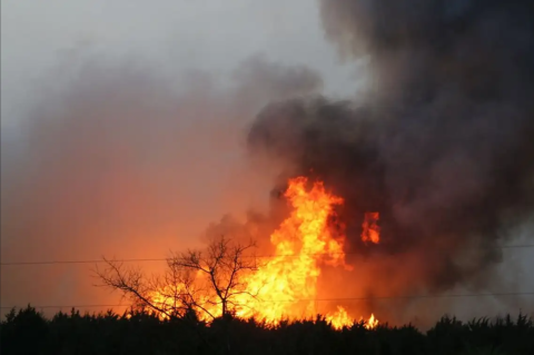
Soil moisture is an important indicator of wildfire probability, which is also driven by climate, fuel, ignition, and topography (Levi, 2022). Climate change is increasing temperatures, which can decrease soil moisture. Decreased soil moisture increases the flammability of landscape fuels and thus increases the probability of a wildfire ignition. Wildfires can impact thousands of acres across the Rio Grande and Red River basins and can cost millions of dollars in suppression efforts (Weir et al., 2017). Current research indicates that soil moisture information could improve wildfire danger assessments (Levi et al., 2019). However, traditional wildfire danger indices are based on temperature, precipitation, and relative humidity, and do not incorporate measured soil moisture information.
Climate change is causing wildfires to burn more acres and become less predictable (Environmental Protection Agency, 2024). As a result, there is a need among resource managers to improve the accuracy of wildfire danger indices on the landscape.
Advances in satellite, in-situ monitoring, and improved soil moisture models have increased the quality and availability of soil moisture data, which has increased the feasibility of including it in wildfire danger indices. As a result, researchers at Oklahoma State University and the University of Georgia are expanding the capabilities of the Newhall Simulation Model to improve the prediction of wildfire probability in the Red River and Rio Grande Basins. The Newhall Simulation Model is a simple soil water budget model and has been updated to improve soil moisture modeling through a capability known as rNewhall Soil Moisture (rNewhall). rNewhall utilized the Oklahoma Mesonet’s in-situ soil moisture monitoring capabilities to validate modeled soil moisture when assessing wildfire probability.
Key Issues Addressed
Many current wildfire danger indices do not incorporate measured soil moisture data in their prediction of wildfire probability. For example, commonly used wildfire danger indices, such as the Keetch-Byram Drought Index (KBDI), fine fuel moisture code, and duff moisture code estimate soil moisture through temperature and precipitation (Krueger et al., 2023). When these wildfire danger indices were developed, there was an insufficient amount of soil moisture information. The incorporation of in-situ, remotely sensed, and modeled soil moisture information into wildfire danger indices can improve the accuracy of wildfire danger assessments.
Traditional wildfire danger indices often lack the ability to predict changes in soil moisture at relevant time scales needed by resource managers engaged in decision making. Indices such as the KBDI can lag in their response to changes in soil moisture conditions because it is calculated using observable atmospheric variables. Wildfire conditions can change daily, which makes it imperative that resource managers can access information that accurately captures rapidly changing soil moisture conditions.
The increased availability of in-situ soil moisture information is enabling researchers to quantify the relationship between soil moisture, fuel conditions, and wildfire occurrence. As a result, additional dialogue is needed to understand how land managers can utilize soil moisture information in wildfire risk assessment, planning, and decision-support tools.
Project Goals
- Modify existing Newhall Soil Moisture model to predict daily changes in soil moisture conditions in the upper meter of the soil layer
- Use rNewhall to model daily changes in soil moisture conditions at multiple depths at the watershed scale across the Red River and Rio Grande Basins
- Incorporate soil moisture information into rNewhall to improve the prediction of wildfire probability
- Identify interests and information needs of researchers and land managers to understand how soil moisture information can be incorporated into wildfire modeling, risk assessment, planning, and decision-support tools
Project Highlights
The Oklahoma Mesonet: The approximately 120 soil moisture monitoring stations are one of the densest in-situ soil moisture monitoring networks globally, key for validating the modeled output of rNewhall.
- Enhanced Ability to Model Soil Moisture: rNewhall is a processed based model for soil moisture modeling. The model generates a soil profile utilizing factors such as soil depth at 10 user-specified increments. Additionally, researchers updated rNewhall to handle different physical soil properties that can include situations where the soil moisture is greater than the field capacity, the maximum amount of water the soil can retain without water draining out. Finally, rNewhall accounts for the effect of gravity in the water cycle. Combined, these features allow rNewhall to more accurately model soil moisture dynamics. During a model evaluation, rNewhall had the greatest skill in modeling soil moisture in the first 100 cm of the soil depth (Levi 2022;Levi et al., 2021).
- A Daily Time Scale: rNewhall introduces an expanded capability to model soil moisture dynamics on a daily time scale, which ensures resource managers can assess wildfire danger with the latest data available.
- Soil Moisture as a Measure for Predicting Wildfire Size: rNewhall was able to quantify the relationship between soil moisture and wildfire occurrence in the 2016-2018 non-growing season (winter months). Researchers used a statistical test to compare modeled output to observed conditions, and found that decreased soil moisture values led to increased wildfire size. The inclusion of soil moisture allowed rNewhall to be relatively accurate in modeling wildfire size within the Red River Watershed (Levi, 2022).
- Researchers and Land Managers in Dialogue: Thirty-four researchers and land managers participated in a one-day workshop held in April 2019 at the 6th International Fire Behavior and Fuels Conference, hosted by the International Association of Wildland Fire. Participants discussed current trends in wildfire occurrence and opportunities to incorporate soil moisture in wildfire danger assessment.
Lessons Learned
Most regions do not have a highly dense network of in-situ soil moisture measurement tools, like those available through the Oklahoma Mesonet, which makes it difficult to incorporate soil moisture information into wildfire danger assessments. Challenges, such as model assumptions, remain. rNewhall models grasslands as the primary fuel, which may limit its applicability outside of the Rio Grande and Red River Basins. The research team needs to further investigate the model's limitations outside of the Rio Grande and Red River Basins to ensure the accuracy of rNewhall as a predictor of wildfire probability in other wildfire prone regions. In the meantime, it is essential for resource managers to understand what spatial data is available and model assumptions prior to utilizing this model for their wildfire probability needs outside of Oklahoma.
In Oklahoma, soil moisture data are readily accessible to researchers to support model validation. Outside Oklahoma, a central location for researchers to access soil moisture datasets would increase the accessibility and ease of use of rNewhall.
Soil moisture has many potential operational uses within wildfire management (Krueger et al., 2023). Using soil moisture data opens the opportunity for live and dead fuel moisture modeling during the growing and non-growing wildfire seasons. Live and dead fuel moisture are two variables directly related to soil moisture conditions and subsequent wildfire severity.
rNewhall was developed in R. However, numerous programming languages exist. Future collaborations utilizing rNewhall could be improved by maintaining consistent programming languages across the research team to better streamline the development process.
Resource managers and stakeholders intuitively understand the importance of soil moisture in relation to wildfire danger. However, approximately one-third of the April 2019 workshop attendees were unaware of recent researchindicating the utility of such information in wildfire danger prediction. Stakeholders identified a need to increase the quantity and quality of available soil moisture data to determine how soil moisture can be integrated effectively into existing wildfire danger rating systems (Yang et al., 2023).Additionally, statistical and mechanistic modeling approaches are needed to better understand the relationship between soil and fuel moisture conditions.
Next Steps
- Calibrate and test rNewhall to determine the model’s physical limitations outside of the Rio Grande and Red River Basins to ensure the accuracy of rNewhall as a predictor of wildfire probability in other wildfire prone regions.
- Researchers are working to overcome the logistical challenges of utilizing soil moisture metrics. This includes how to leverage a combination of in-situ, remote, and modeled soil moisture to improve operational wildfire danger assessments.
- Develop standardized soil moisture indices to ensure transferability to other wildfire-prone regions with different landscapes and soil types.
- Incorporate measured soil moisture into existing wildfire danger rating systems (Yang et al., 2023).
- Improve the accessibility of soil moisture data through the development of the National Coordinated Soil Moisture Monitoring Network (Baker et al., 2022).
Funding Partners
- South Central Climate Adaptation Science Center (SC CASC)
- U.S. Department of Agriculture (USDA) - Natural Resources Conservation Service
Resources
- Environmental Protection Agency (2024). “Climate Change Indicators: Wildfires.”
- Krueger et al. (2023). “Using soil moisture information to better understand and predict wildfire danger: a review of recent developments and outstanding questions.” International Journal of Wildland Fire: 111-132.
- Yang, J., T.E. Ochsner, E.S. Krueger. (2023). “Megafire Risk Evaluation System (MERES) for Projecting Future Megafire Probability in the Southern Great Plains. South Central Climate Adaptation Science Center funded project.”
- Levi, Matthew. (2022). “Wildfire Probability Mapping Based on Regional Soil Moisture Models.”
- Baker et al. (2022). “Working toward a National Coordinated Soil Moisture Monitoring Network: Vision Progress, and Future Directions.” Bulletin of the American Meteorological Society103(12): E2719-E2732.
- Levi et al. (2021). “Integrating detailed soil and climate information in a simple model for soil moisture predictions across large areas.”
- Snitker et al. (2019). “An improved Newhall Simulation Model for predicting soil moisture.”
- Levi et al. (2019). “Rating Fire Danger from the Group Up.” Eos 100.
- Oklahoma Mesonet
Weir et al. (2017). “Wildfires in Oklahoma.”
Contacts
- Matthew Levi, University of Georgia: matthew.levi@uga.edu
- Erik Krueger, Oklahoma State University: erik.krueger@okstate.edu
- Tyson Ochsner, Oklahoma State University: tyson.ochsner@okstate.edu
CART Lead Author
Liam Thomspon, CART Student Writer, University of Oklahoma
Suggested Citation
Thompson, L., C. (2024). “Using Regional Soil Moisture to Map Wildfire Probability in the Rio Grande and Red River Watersheds.” CART. Retrieved from https://www.fws.gov/project/using-regional-soil-moisture-map-wildfire-probability


