


Visit Us
From a multi-refuge Visitor Center full of exciting exhibits to the possibility of seeing charismatic mega-fauna like red wolves and black bear, Alligator River National Wildlife Refuge offers year-round opportunities for learning and adventuring. The refuge is open all year round during daylight hours. We have great paddling trails, a wildlife drive, two wildlife walking trails, and all types of wildlife and habitat for you to learn about!
Activities
Don’t miss the National Wildlife Refuges Visitor Center on Roanoke Island and its state-of-the-art exhibits—all free! Or, venture to the Dare County mainland to Alligator River National Wildlife Refuge’s popular Murphy Peterson Wildlife Drive, where locals compete to see who can count the most black bear in one evening. Wildlife abounds in the farming and moist soil management units along the Wildlife Drive. If you are looking for adventure, a great way to explore the refuge is by canoe or kayak, using the refuge’s 15+ miles of color-coded paddling trails. There are two half-mile, universally accessible wildlife trails for a leisurely stroll in a beautiful, quiet and secluded place. Enrich your experience by joining us for an open-air tram tour or interpretive program.For wildlife photographers, there are great photographic opportunities if you have patience. Hunting and fishing are allowed with restrictions. In fall, the refuge joins other eastern North Carolina refuges and partner organizations each year to host the Wings Over Water Wildlife Festival, a celebration of migrant waterfowl and other local wildlife.
Trails
The refuge has two half-mile trails. In addition, hiking is allowed in all areas open to the public, such as roads.
Related Documents
Other Facilities in the Complex
A National Wildlife Refuge Complex is an administrative grouping of two or more refuges, wildlife management areas or other refuge conservation areas that are primarily managed from a central office location. Refuges are grouped into a complex structure because they occur in a similar ecological region, such as a watershed or specific habitat type, and have a related purpose and management needs.
There are 9 national wildlife refuges in the Coastal North Carolina National Wildlife Refuges Complex. The Project Leader for the Complex supervises the Refuge Managers who are responsible for managing these refuges. However, there are five distinct and separate administrative offices. Alligator River and Pea Island National Wildlife Refuges are administered from the Alligator River National Wildlife Refuge Headquarters in Manteo, NC. An administrative office at the Mackay Island National Wildlife Refuge Headquarters in Knotts Island, NC manages both Mackay Island and Currituck National Wildlife Refuges. An office at Mattamuskeet National Wildlife Refuge administers Mattamuskeet, Swanquarter, and Cedar Island National Wildlife Refuges. Pocosin Lakes National Wildlife Refuge, Roanoke River National Wildlife Refuge, Great Dismal Swamp National Wildlife Refuge, Back Bay National Wildlife Refuge, and Edenton National Fish Hatchery each have separate administrative offices.
All of the Coastal North Carolina National Wildlife Refuges, Great Dismal Swamp National Wildlife Refuge, Back Bay National Wildlife Refuge, and Edenton National Fish Hatchery are open to public visits for nature-based recreational enjoyment. Priority public uses are hunting, fishing, wildlife observation, wildlife photography, environmental education, and interpretation.


Rules and Policies
In addition to these provisions, all State laws, County codes, and Title 50 of the Code of Federal Regulations apply on the Refuge. If you have any questions about the legality of any activity, please contact the Refuge Manager.
General Regulations
- The Refuge is open during daylight hours only (1/2 -hour before sunrise to 1/2 -hour after sunset).
- Camping, open fires, feeding or baiting of wildlife, swimming in Refuge canals, or entering any area posted with “Area Closed” signs is prohibited.
- All domestic pets (dogs, cats, horses, etc.) must be properly confined, leashed (10-foot maximum), or haltered and under owner control at all times.
- Littering or dumping of garbage, refuse, sewage, debris, or other wastes or poisons is prohibited.
- The use of a spotlight, automotive headlight, or other artificial light to spot, observe, locate, or take any animal is prohibited.
- Taking, possessing, injuring, disturbing, damaging, destroying, or collecting any plant or animal (or attempting these actions) is prohibited.
- Destroying, defacing, damaging, disturbing, or removing any private or public property, including any natural object or artifact, is prohibited. The use or possession of metal detectors or similar devices is prohibited.
- Disturbing, molesting, or interfering with any person engaged in an authorized activity is prohibited. Engaging in any act of indecency or disorderly conduct (as defined by State or local laws) is prohibited.
- Entering or remaining on the Refuge when under the influence of alcohol or a controlled substance is prohibited.
- Begging or soliciting in any form or conducting a commercial enterprise on the Refuge is prohibited unless authorized by a Commercial Special Use Permit.
- Refuge visitors are reminded that the Wildlife Drive is adjacent to several hunting areas. Please be aware that hunting is allowed during specific seasons, and be cautious and courteous when visiting areas shared with other refuge users.
Vehicles/Roads/Trails
- The speed limit on all Refuge roads, unless otherwise posted, is 35 miles per hour. State traffic laws that govern the use and operation of vehicles apply on the Refuge.
- Motorized vehicles are allowed only on designated roads.
- Refuge roads closed to motorized vehicles are open for walking and bicycle riding, unless posted as closed to all entry. Horseback riding is allowed only on roads open to motorized vehicles. Groups of 6 or more horses must have a Refuge Special Use Permit.
- Operating any vehicle or boat that does not bear valid license plates or identification numbers and that is not properly lighted, certified, registered, or inspected according to State laws is prohibited. ATV/UTVs (3-wheelers, 4-wheelers, dirt bikes, etc.) are prohibited.
- Stopping or parking a vehicle (either attended or unattended) on a road, trail, or firelane such that it blocks the free movement of other vehicles is prohibited.
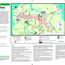
Locations
From the intersection of US Hwy 64 Business and the Bypass on Roanoke Island, follow US Hwy 64 Business west through Manteo to the north end of the island, approximately 5 miles. The National Wildlife Refuges Visitor Center, which houses administrative Offices for Alligator River National Wildlife Refuge, is on the left, just past the Lost Colony, Elizabethan Gardens, and Fort Raleigh National Historic Site.
The Creef Cut Trail starts where Milltail Road meets Highway 64. Milltail Road is part of the wildlife drive and one popular entrance to the refuge. A paved parking lot is available here.
From the east: take the US Highway 64 bypass from Roanoke Island west across the bridge through the town of Manns Harbor. Milltail Road is 6 miles west of Manns Harbor, on the left.
From the west: follow US Highway 64 across the Lindsey C. Warren bridge over the Alligator River. Milltail Road is approximately 7.5mi from the end of the bridge, on the right.
Buffalo City Road is part of the refuge Wildlife Drive. The Sandy Ridge Wildlife Trail is found at the end of Buffalo City Road, along with a boat launch for the Milltail Creek Paddling trails.
From the east: take the US Highway 64 through the town of Manns Harbor. Buffalo City Road is approximately 10 miles west of the town, on the left.
From the west: follow US Highway 64 across the Lindsey C. Warren bridge over the Alligator River. Buffalo City Road is 4 miles east of the end of the bridge, on the right.