Visit Us

The Charles M. Russell Wetland Management District manages six Waterfowl Production Areas and numerous conservation easements. Four satellite National Wildlife Refuges lie within the District's boundaries, with three of those open to the public for hunting, wildlife observation and wildlife photography. The Waterfowl Production Areas are open to the public for hunting, trapping, wildlife observation, and wildlife photography. The easements are privately owned and thus closed to the public, unless landowners allow access. The District headquarters is located in the Charles M. Russell National Wildlife Refuge Complex headquarters in Lewistown, MT.
Location and Contact Information
About Us
The Charles M. Russell Wetland Management District is a part of the Charles M. Russell National Wildlife Refuge Complex headquartered in Lewistown, MT. The District boundary encompasses five counties in central and south-central Montana: Petroleum County, Musselshell County, Golden Valley County, Yellowstone County, and Stillwater County. Within this 9,175 square mile authority area lie five Waterfowl Production Areas (WPAs). They are: War Horse WPA, Hailstone WPA, Spidel WPA, Tew WPA, and James L. Hansen WPA. Importantly, a sixth WPA - Clark's Fork WPA, is managed by the District, but resides outside of District boundaries in Carbon County. Additionally, several conservation easements on privately owned lands do reside within and are an integral part of the District as well.

Also within District boundaries are four small satellite National Wildlife Refuges (NWRs). These Refuges are separate from the District's jurisdiction and are often referred to as "the District and associated Refuges". The names of these Refuges are: War Horse NWR, Hailstone NWR, Lake Mason NWR, and Grass Lake NWR. In the event of visiting these Refuges, it is important to note that they have their own rules and regulations separate from District jurisdictional lands - the WPAs. *Note: Grass Lake NWR is currently closed to the public pending the review and implementation of a Comprehensive Conservation Plan (CCP) and Environmental Assessment (EA).
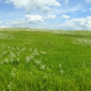
A majority of the District's upland habitat remains native mixed-grass prairie with sagebrush sagebrush
The western United States’ sagebrush country encompasses over 175 million acres of public and private lands. The sagebrush landscape provides many benefits to our rural economies and communities, and it serves as crucial habitat for a diversity of wildlife, including the iconic greater sage-grouse and over 350 other species.
Learn more about sagebrush and/or greasewood present in various densities. The interface where sagebrush and wetland ecosystems merge provides a unique habitat transition and can be seen throughout the District.
Wetland Management Districts
Wetland Management Districts (WMDs) are designated areas usually following the boundaries of several counties within a state that a U.S. Fish and Wildlife Service office manages wherein several Waterfowl Production Areas (WPAs) lie. WPAs are small natural wetlands and grasslands that provide breeding, resting and nesting habitat for waterfowl, shorebirds, grassland birds and other wildlife. The Fish and Wildlife Service acquires waterfowl production areas under the authority of the Migratory Bird Hunting and Conservation Stamp Act, primarily using funds from the sale of Federal Duck Stamps. The Refuge System’s 38 wetland management districts comprise thousands of waterfowl production areas – almost all in the Prairie Pothole Region of the Northern Great Plains. WPAs acquired by the Fish and Wildlife Service in fee title provide public opportunities for hunting, fishing and other wildlife-dependent recreation. The Fish and Wildlife Service also purchases conservation easements on WPAs; these easements allow property owners to continue to live on and work their land while conserving wetlands and grasslands on the property. While a National Wildlife Refuge is typically a contiguous block of land, most WMDs are made up of scattered WPAs across multiple counties. While a National Wildlife Refuge is closed to many public-use activities unless specifically opened, fee-title WPAs in a WMD are open to certain types of public recreation unless specifically closed. Access to WPA lands under a conservation easement conservation easement
A conservation easement is a voluntary legal agreement between a landowner and a government agency or qualified conservation organization that restricts the type and amount of development that may take place on a property in the future. Conservation easements aim to protect habitat for birds, fish and other wildlife by limiting residential, industrial or commercial development. Contracts may prohibit alteration of the natural topography, conversion of native grassland to cropland, drainage of wetland and establishment of game farms. Easement land remains in private ownership.
Learn more about conservation easement is controlled by the property owner.
Waterfowl Production Areas
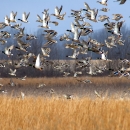
For nearly a century, the U.S. Fish and Wildlife Service (USFWS) has used funds from the sale of federal Duck Stamps to conserve some of the most threatened and productive migratory bird habitats in the nation. Duck Stamp funds have allowed the Refuge System to conserve in perpetuity thousands of small wetlands, pothole areas, and the grasslands immediately associated with them, which are called Waterfowl Production Areas (WPAs).
Together, these often-small wetlands and associated grassland units conserve more than 3 million acres of habitat. WPAs are administratively organized into 38 WMDs with individual districts often spanning many counties.
WPAs are small natural wetlands and grasslands that provide breeding, resting and nesting habitat for waterfowl, shorebirds, grassland birds, insects, and other wildlife. They help reduce erosion, clean and protect groundwater, and reduce flooding. WPAs owned by the Service also provide ample opportunities for public access and wildlife-dependent recreation such as hunting, wildlife viewing, and photography.
As units of the Refuge System, WPAs are generally subject to the same rules and regulations as National Wildlife Refuges, but are distinct in geography and management.
One key difference between Wildlife Refuges and WPAs is that all WPAs are open to hunting, fishing, and trapping in accordance with State laws and regulations unless public safety or other concerns dictate otherwise. In contrast, Wildlife Refuges are closed to recreation activities unless specifically opened.
Easements
Money from Duck stamp sales and the Land and Water Conservation Fund are also used to buy grassland and wetland easements which pay landowners to permanently protect grasslands and wetlands without relinquishing ownership. Conservation easements are an effective way to preserve vital habitats for wildlife and future generations of landowners, hunters, birdwatchers, anglers, and anyone that relies on our natural resources for the beauty, recreation, and ecosystem services they provide.
FmHA Easements
FmHA conservation easements are authorized to establish easements for conservation, recreation, and wildlife purposes on properties that were foreclosed by the federal government (Consolidated Farm and Rural Development Act, as amended, 7 U.S.C. 1985(g)). The purposes of these perpetual easements are the preservation and maintenance of wetland and floodplain areas, as well as protection and enhancement of plant and animal habitats and populations. Easement covenants include the following: no dwellings, barns, outbuildings, or other structures shall be built; the vegetation or hydrology will not be altered in any way or by any means or activity; and the landowner shall be responsible for compliance with all federal, state, and local laws for the control of noxious plants. The United States retained rights to inspect properties for compliance and to establish, reestablish, or enhance wetland functional values and vegetation. Easements do not provide for public access although the landowner may grant permission for entry for recreational purposes. The Service was designated as the easement manager on those easements worthy of inclusion into the National Wildlife Refuge System (7 U.S.C. 2002).
Flowage easements. The Service administers other types of easements that are part of the refuges and WPAs in the District. Flowage easements were purchased in the late 1930s. For management purposes, these entitle Refuges water flowage easements. These are the covenants included with flowage easements:
The exclusive and perpetual right and easement to flood with water, and maintain and operate an artificial lake, and/or to raise the water level of a natural lake or stream, upon the lands hereinafter described, by means of dams, dikes, fills, ditches, spillways, and other structures, for water conservation, drought relief, and for migratory bird and wildlife conservation purposes, and/or upon said lands and waters to operate and maintain a wildlife conservation demonstration unit and a closed refuge and reservation for migratory birds and other wildlife.
State Grazing Leases. The Service purchased three grazing leases from the state of Montana’s Department of Natural Resources and Conservation. These are 10-year renewable leases for grazing privileges on state lands within a Refuge or WPA, requiring an annual payment based on the available animal unit months. The Service does not regularly use these leases for livestock grazing; rather, they are predominantly kept in non-use to provide residual cover for nesting migratory birds and other wildlife. The three leases are located adjacent to Grass Lake NWR (the lease is 640 acres), Spidel WPA (160 acres), and Lake Mason Unit (160 acres) of Lake Mason NWR.
Satellite Refuges
Satellite NWRs are unstaffed and have been established by Executive Order and may contain Service lands and private lands under easement within their boundaries. These lands are all part of the National Wildlife Refuge System - a network of public lands administered by the U.S. Fish and Wildlife Service (Service) set aside specifically for wildlife.
Within District boundaries are four small satellite National Wildlife Refuges (NWRs). These Refuges are separate from the District's jurisdiction and are often referred to as "the District and associated Refuges". The names of these Refuges are: War Horse NWR, Hailstone NWR, Lake Mason NWR, and Grass Lake NWR. In the event of visiting these Refuges, it is important to note that they have their own rules and regulations separate from District jurisdictional lands - the WPAs. *Note: Grass Lake NWR is currently closed to the public pending the review and implementation of a Comprehensive Conservation Plan (CCP) and Environmental Assessment (EA). This Refuge is expected to open to limited public access in Spring of 2025.
Tours
District lands are such that five Waterfowl Production Areas (WPAs) and four satellite National Wildlife Refuges (NWRs) are spread over five counties in remote areas. A sixth WPA lies within an adjacent county outside of the District's boundary but is still managed by the District. Visiting each WPA and Refuge requires multiple days and effective time management. Some roads into District lands are unimproved, thus entering them during inclement weather is not advised. Please plan accordingly.
What We Do
The National Wildlife Refuge System is a series of lands and waters owned and managed by the U.S. Fish and Wildlife Service. Wildlife conservation is at the heart of the Refuge System, of which Wetland Management Districts are an integral part of. It drives everything we do from the purpose a Refuge, Waterfowl Production Area, and Wetland Management District is established, to the recreational activities offered there, to the resource management tools we use.
The overall management goal at the Charles M. Russell Wetland Management District is to promote biological diversity and maintain the natural abundance of native plants and wildlife. Science is the foundation upon which conservation decisions are made. We use research, monitoring, and the best-available science to inform our work to conserve wildlife and wildlife habitat.