Projects and Research
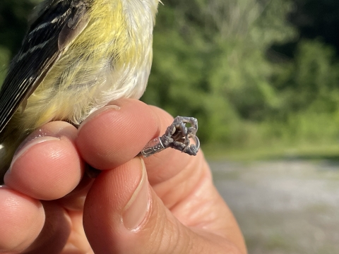
Monitoring Avian Productivity and Survivorship (MAPS) aka. Bird Banding
The Monitoring Avian Productivity and Survivorship (MAPS) Program was created by The Institute for Bird Populations in 1989 to assess and monitor the population of over 150 species of North American birds to provide critical conservation and management information. The MAPS Program uses a standardized fine gauge mist netting and banding program. This program runs continent-wide through a network of monitoring stations staffed by both professional biologists and trained volunteers.
Since 2003, Clarks River National Wildlife Refuge has been involved with the MAPS program. During the summer breeding season (May - August), a banding station is operated by refuge staff and volunteers. At this location, once every 10 days, fine gauge mist nest are used to capture songbirds. They are then carefully removed from the nets and given a small leg band with an identification number on it. Data such as species, age, sex, and health condition are recorded for each captured bird. The results of this monitoring effort helps determine population trends in many species of migratory songbirds for the overall data collection in the MAPS program, but the data can also assist with forest management at the Refuge level as well.
Bat Surveys
Bottomland hardwood forests are important to southeastern bats as both roosting and foraging habitat. Thus, the loss of this habitat type is considered to be linked to the declining of southeastern bat species. Other issues negatively effecting bat populations include white-nosed syndrome, and the overuse of pesticides causing a reduction in their food source. All of these factors have dramatically increased the concern for bat populations. This makes Clarks River National Wildlife Refuge vital in providing quality habitat for these species.
Numerous bat surveys have been conducted on the refuge since 2006. These surveys include acoustical analyses and mist netting efforts (sometimes referred to as a bat blitz). During the acoustical analysis, an ANABat System is used. This system is designed to identify bats by detecting and analyzing their echolocation calls. The system can be set-up in a stationary location or biologist can drive a designated route while using the ANABat System. During Bat Blitz efforts, mist nets are used to capture the bats, then biologist collect and record data from the bats before releasing them.
Xero-hydric Flatwoods
The Refuge contains some of the most extensive tracts of xero-hydric flatwoods in the state. This unusual type of forest contains a fragipan, a dense subsoil layer of clay that restricts drainage. The result is soil saturated with water in the winter and spring, but then extremely dry during summer and fall. This wet-dry cycle creates growing conditions where wetland plants and plants that favor dry uplands can be seen growing together. It is thought that historically this habitat was maintained by periodic fires. The refuge continues to work with partners to find techniques that would ensure proper management of this important habitat.
The refuge offers ample opportunity for research and investigations to interested parties. Those who are interested, must complete a Special Use Permit and have it approved before research can begin.


