Visit Us
National wildlife refuges offer us all a chance to unplug from the stresses of daily life and reconnect with our natural surroundings. Hart Mountain’s diverse landscape and habitat offer visitors the chance to see an array of wildlife such as California bighorn sheep, coyotes, pronghorn and much more. Visitors can enjoy viewing any of the 246 species of birds that call the refuge home, searching for petroglyphs, or fishing at a quiet pond.
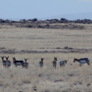
Driving through the west side of the refuge, visitors experience sweeping views of the Warner Valley while passing deep canyons. On the east side of Hart Mountain, some may choose to camp near lush aspen groves, wander through secluded pine forests or, if lucky, watch pronghorn or sage grouse in the sagebrush sagebrush
The western United States’ sagebrush country encompasses over 175 million acres of public and private lands. The sagebrush landscape provides many benefits to our rural economies and communities, and it serves as crucial habitat for a diversity of wildlife, including the iconic greater sage-grouse and over 350 other species.
Learn more about sagebrush -grassland habitat typical of the Great Basin.
Located in the high desert of Oregon, precipitation (an average of 12” annually) comes primarily as winter snow or spring rains. Temperatures vary between extreme cold in the winter and hot, dry summer conditions. However, the Refuge provides an oasis in the desert. Snow melt and springs feed many seasonal and year-round creeks and a natural hot spring nestled against the eastern base of Warner Peak provides a soothing retreat for area visitors.
The Refuge is free to visit. Vault toilets are available in the campgrounds.
Activities
The refuge has many activities for visitors to enjoy. To learn more about what is available, pick up a refuge brochure (these are available on our website, at the Refuge headquarters building, or by request).
Related Documents
Other Facilities in the Complex
Hart Mountain National Antelope Refuge is managed as part of the Sheldon-Hart Mountain National Wildlife Refuge Complex. You may also be interested in visiting Sheldon National Wildlife Refuge in Nevada!
A National Wildlife Refuge Complex is an administrative grouping of two or more refuges, wildlife management areas or other refuge conservation areas that are primarily managed from a central office location. Refuges are grouped into a complex structure because they occur in a similar ecological region, such as a watershed or specific habitat type, and have a related purpose and management needs. Typically, a project leader or complex manager oversees the general management of all refuges within the complex and refuge managers are responsible for operations at specific refuges. Supporting staff, composed of administrative, law enforcement, refuge manager, biological, fire, visitor services, and maintenance professionals, are centrally located and support all refuges within the complex.
Rules and Policies
All public use recreational activities on Hart Mountain National Antelope Refuge are regulated to protect wildlife, this differs from regulations on other public lands. While managed to protect wildlife and maintain the rugged, remote, and undeveloped character of the Refuge, a wide variety of opportunities are available for visitors to experience and explore. As a visitor, it is your responsibility to understand and follow the rules and regulations to protect wildlife and to ensure your own safety. Be safe. Be prepared. Be responsible!
Locations
From western Oregon/ northeast California (Bend-228 miles, Burns-192 miles, Klamath Falls-159 miles, Alturas, CA-117 miles) via Lakeview, Oregon (best road conditions & most paved roads):
1) Follow Highway 395 to the junction with Highway 140 east.
2) Following signs for Adel and Winnemucca, Nevada, turn east onto Highway 140.
3) Follow Highway 140 east for 15.6 miles.
4) Following the sign for PLUSH and HART MTN. REFUGE, turn north onto the Plush Cuttoff (County Highway 3-13).
5) Continue 19.6 miles heading north through Plush (gas, grocery, and restaurant).
6) Follow the sign to Hart MT. and Frenchglen turning east onto Hart Mountain Road (County Highway 3-12).
7) Continue east and north 23 miles following the Hart Mountain-Frenchglen Road past the Warner Valley Wetlands and restrooms (2 miles) and Camp Hart Mountain and restrooms (13.5 miles) to the Refuge Headquarters (13.5 miles paved road plus 9.5 miles maintained gravel road).
Alternate Route from Bend (207 miles) or Burns (129 miles) via Highway 20 and Hogback Road (shortest route— paved and maintained gravel roads):
1) From Highway 20 turn south onto Highway 395
2) Follow Highway 395 south for 64 miles past the Highway Wells Rest Area (60 miles).
3) Following the sign for HOGBACK RD, PLUSH, HART MT ANTELOPE REF., turn east onto Hogback Road (County Road 3-10).
4) Follow Hogback Road (County Road 3-10) for 20 miles.
5) Follow signs at the three-way intersection for HART MT and FLAGSTAFF LK (County Road 3-11)
6) Follow Flagstaff Lake Road (County Road 3-11) for 8.6 miles
7) Turn north at the intersection onto the Hart Mountain-Frenchglen Road (County Road 3-12)
8) Continue 9.5 miles northeast past Camp Hart Mountain and restrooms (400 feet) to the Refuge Headquarters.
From Frenchglen (48 miles), Malheur National Wildlife Refuge, and Steens Mountains (maintained gravel road):
1) Follow Highway 205 south from Frenchglen (gas, groceries, restaurant, and hotel) for 7 miles.
2) Turn west onto Rock Creek Road.
3) Follow Rock Creek Road (becoming Hart Mountain-Frenchglen Road) for 41 miles to the Refuge Headquarters.
From Denio Junction, Nevada (111 miles) via Fields, Oregon (80 miles) (paved and maintained gravel roads):
1) Follow Highway 292 (becoming Fields-Denio Road/ Highway 205) north from Denio Junction, NV (groceries, restaurant, hotel) for 68.5 miles
2) Turn west onto Rock Creek Road.
3) Follow Rock Creek Road (becoming Hart Mountain-Frenchglen Road) for 41 miles to the Refuge Headquarters.


