Written By


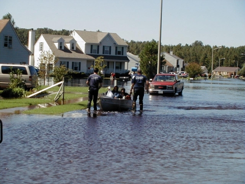
In late October 2012, near the end of hurricane season, Hurricane Sandy—1,000 miles wide, with winds up to 80 miles per hour—came ashore near Atlantic City, New Jersey. Its arrival during a full moon and high tide created record-breaking storm surge in parts of New Jersey, New York, and Connecticut. Wind, rain, and surf from the “superstorm” led to 150 deaths and more than $65 billion in damages.
Any way you look at it, Sandy was a disaster. Nearly a decade later, the storm and how we responded to it have provided valuable lessons to help communities, state and federal land managers, and many others prepare for next time.
Following Sandy, the U.S. Fish and Wildlife Service received $167 million in federal funding to rebuild and improve storm-damaged facilities and wildlife habitat and make the coast more resilient in the face of rising sea levels and more-frequent intense storms.
A resilient coast absorbs storm surge and wave energy, recovering quickly with little need for repair. It’s a place where wildlife and people thrive. Working with nature, we can create such a coast.
What does working with nature look like?
It's healthy salt marshes that soak up rising water like sponges and provide habitat for at-risk species like the saltmarsh sparrow, whose numbers are declining rapidly.
It’s free-flowing rivers that reduce flooding of nearby communities and let migratory fish swim from the ocean to historical spawning grounds.
And it's oyster reefs and other living shorelines that buffer coastal zones from wave erosion and create new habitat for commercially and recreationally valuable marine species.
In short, nature provides solutions that benefit people and wildlife, improve with time, and have high returns on investment.
The Service and our partners—towns, states, Tribes, universities, industries, landowners, and nonprofits—hope to make working with nature a new normal up and down the Atlantic Coast. Nearly a decade after Hurricane Sandy devastated communities and wildlife habitat from Florida to Maine, incredible work has been done—beaches, dunes, and marshes restored; dams removed; and living shorelines built.
This is what success—in the form of effective projects and lessons-learned—looks like....
Gandys Beach, New Jersey
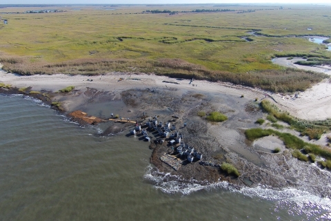
The Challenge
New Jersey's Gandys Beach was once favored by rufa red knots as a waypoint for feasting on horseshoe crab eggs. But sea-level rise and storms have eroded the sandy shoreline and made it a less hospitable foraging habitat for these birds—among the longest-distance migrants in the animal kingdom.
Federally listed as threatened, the red knot has an urgent need for healthy beach habitat.
Sustaining this habitat along Delaware Bay, with its intense wave action, is difficult, though. It’s becoming more so with increased climate impacts.
The Approach
The Gandys Beach “living shoreline” project—a collaboration by the Service, The Nature Conservancy in New Jersey, Partnership for the Delaware Estuary, Rutgers University’s Haskin Shellfish Research Laboratory, Stevens Institute of Technology, and others—aimed to meet this challenge in an ecologically sensitive manner.
In addition to reducing erosion, the group sought to bolster the bay’s wild oyster population. Their answer: reef-like breakwaters to protect the shore while attracting oyster larvae.
Supported by $880,000 in Sandy resilience funding through a grant from the National Fish and Wildlife Foundation, the partners and volunteers installed 10-foot by 30-foot breakwaters made of interlocking concrete blocks called Oyster Castles®. Along with bags of clam and oyster shells, they were set up to protect about 2,750 feet of shoreline. Gaps were left between the breakwaters so that spawning horseshoe crabs could reach the beach.
This project also included long-term monitoring for such things as erosion rates, elevation changes and oyster recruitment and survival that will inform future shoreline protection.
The Outcome
There’s much to be excited about: the structures have withstood the bay’s extreme conditions and reduced erosion rates. Oyster numbers are high, and horseshoe crabs pass easily through the gaps.
There also have been lessons learned. To provide oyster habitat, the breakwaters were built low in the intertidal area. This left them submerged at mid-high tide and less effective than hoped at reducing wave energy. In one spot, erosion worsened, prompting successful reconfiguration of the breakwaters.
The 2021 hurricane season brought additional challenges. Storm events—in particular the remnants of Hurricane Ida—led to significant sediment loss at Gandys.
“I know we have slowed erosion, and it would have been worse without the structures," said Danielle McCulloch, the Service's project lead. "Still, we need something big enough to stabilize the beach and save the salt marsh salt marsh
Salt marshes are found in tidal areas near the coast, where freshwater mixes with saltwater.
Learn more about salt marsh behind it."
In late 2021, the team was exploring other innovative ecologically attuned approaches to do just that.
Ultimately, real-world experience with Gandys Beach and other living shorelines is informing development of new projects and helping address regulatory hurdles to make it easier to deploy natural approaches to climate adaptation.
Great Dismal Swamp National Wildlife Refuge, Virginia and North Carolina
The Challenge
In 2011, lightning started a wildfire that burned for more than 100 days in the 112,000-acre Great Dismal Swamp National Wildlife Refuge, the largest intact remnant of a wetland that once covered more than a million acres in Virginia and North Carolina.
While the formation of the swamp dates back almost 10,000 years, the conditions that fanned the flames were of more recent, human origin.
Centuries of draining Great Dismal Swamp to harvest timber and grow crops, coupled with development along the swamp’s margins, compromised the landscape’s natural drainage.
The changes dried out the swamp’s peat soil and reduced its ability to absorb water. This, in turn, led to elevated fire risk and escalated flooding for the refuge and neighboring communities.
The Approach
At Great Dismal Swamp, undoing centuries of changes made by people to allow the swamp to return to its natural state wasn't an option.
Improved management of the water in ditches once dug throughout the swamp to drain it was possible, though. This was the vision when the Service received more than $3 million in Hurricane Sandy funds to build water control structures in the Portsmouth Ditch area, in the northeastern corner of the swamp.
Work on the project—targeted to improve groundwater storage and reduce drainage impacts to approximately 30,000 acres of the swamp—got underway in summer 2016; it was completed in summer 2017.
The Outcome
Today, monitoring of groundwater and surface-water shows the 12 new structures are increasing water storage as intended.
They’re dispersing the water, allowing it to leave the swamp more slowly, and in more places. A return to more natural drainage patterns is helping keep the swamp’s peat soil moist and fire-resistant and restoring its ability to absorb flood waters.
Data show the groundwater table is leveling out between rain events and dry spells, and doing so at a higher elevation. This means water is conserved in the swamp for longer periods during dry spells.
In Fall 2021, although the area was the driest it had been in 10 years, there was still water in the ditches.
"It's confirmation we're doing something right," said Refuge Manager Chris Lowie.
Reductions in wildfire risk and in downstream flooding, both within the refuge and beyond its boundaries, are good news for people and wildlife.
Pond Lily Dam, Connecticut
The Challenge
New Haven—Connecticut's second-largest city—might seem an unlikely place for a U.S. Fish and Wildlife Service project. From the site of the former Pond Lily Dam on the West River, you easily could walk to buy a guitar, get your nails done, or catch a bus.
That’s part of the point.
When it was removed, Pond Lily Dam was well more than 200 years old and showing its age. Over the years, the dam had contributed to flooding in the busy Woodbridge neighborhood next-door. And if the aged dam one day failed during one of the heavy rain events expected to become more common as our climate changes, the ramifications would have been severe.
The dam, located in the 14-acre Pond Lily Nature Preserve, had ecological impacts, too.
By obstructing rivers, dams such as Pond Lily—many of them built long ago for industrial purposes and now obsolete—contribute significantly to the struggles of migratory aquatic species, including economically and ecologically important fish like river herring.
The Approach
The Service contributed $660,000 in Hurricane Sandy funding to remove Pond Lily Dam and an additional $110,460 to monitor results.
New Haven-based nonprofit Save the Sound oversaw the project with partners, including the Service; the Natural Resource Conservation Service; the dam’s owner, New Haven Land Trust—now part of Gather New Haven; the National Oceanic and Atmospheric Administration (NOAA); and many others.
The Outcome
With Pond Lily Dam’s removal, risk of its failure disappeared. Along the river, native plants have returned, and the preserve remains a popular community fixture.
In early September 2021, almost 5 inches of rain from Hurricane Ida tested capacity of the now free-flowing river and restored floodplain. Surveys by Save the Sound showed significant floodwaters had washed over the floodplain at high velocities. The site’s vegetation held, and the floodplain functioned as anticipated, with no flooding of nearby areas from the site.
Fish returned, too. In 2017, biologists found alewives—one of two species of river herring—upstream of the dam site for the first time. In 2021, alewife migration hit a record high since the dam was removed, with 200 counted.
Recreational uses are critical for projects like Pond Lily: Studies have shown that each mile of river opened so fish can move freely can contribute more than $500,000 in social and economic benefits, such as fishing and tourism.
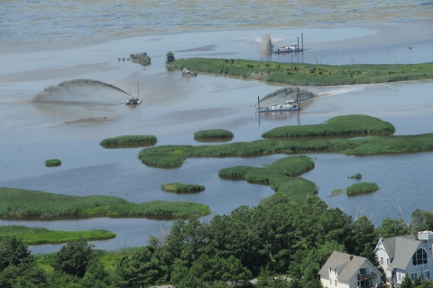
Prime Hook National Wildlife Refuge, Delaware
The Challenge
With its mosaic of salt marsh, freshwater marsh, ponds, wooded swamps, grasslands, and forests, Delaware’s Prime Hook National Wildlife Refuge provides habitat for numerous species on federal and state endangered lists and hundreds of other native plants and animals.
Sea-level rise and more-frequent intense storms have taken a toll at Prime Hook. The refuge’s beaches have receded by hundreds of feet, and storms have washed over its dunes several times, flooding with sea water 4,000 acres of freshwater marsh used by waterfowl and shorebirds.
Hurricane Sandy went further, greatly widening breaches in the dunes, speeding up habitat loss, and worsening flooding on refuge roads and in the nearby community.
The Approach
In 2015, thanks to $38 million in federal Sandy funds, the Service and partners, including the U.S. Army Corps of Engineers, the state of Delaware and NOAA, embarked on an ambitious, multistage restoration at Prime Hook.
One of the largest Department of the Interior-funded coastal marsh restoration projects ever, it began with carving out more than 25 miles of tidal channels to allow the marsh to drain. This network was based in large part on historic channels present before the salt marsh was converted to freshwater impoundments for the benefit of waterfowl.
Contractors pumped more than a million cubic yards of sand dredged from Delaware Bay along nearly 9,000 feet of damaged shoreline to fill the deep cuts caused by Hurricane Sandy and other storms. Afterward, the dunes and restored beach area were planted with beach grasses and shrubs to hold the sand in place.
The Outcome
The impacts have been clear.
People have benefited. As of mid-November 2021, there had been no flood-related closure of Prime Hook Road, which passes through the refuge to Prime Hook beach, since the project’s completion. The road previously flooded during storms and high tides.
Nature has benefited, too. In 2020, a remarkable 16 nesting pairs of piping plovers, which are federally listed as threatened, were counted at the refuge’s restored Fowler Beach. The beach is also providing breeding habitat for state-listed endangered least terns, and the number of spawning horseshoe crabs has rebounded to pre-Sandy numbers.
In addition, healthy, restored marsh areas provide habitat for wildlife, including saltmarsh sparrows and American black ducks, birds that, without our help, could face extinction.
Nature's needs are human needs.
After a natural disaster, it's human nature to rebuild, to put things back the way they were. Following Hurricane Sandy, however, the Service examined what performed well during the storm...and what didn’t. We designed conservation projects to help lands withstand the storms of the future and serve people and wildlife.
Many habitats damaged by Sandy had been altered for human needs over the centuries: salt marshes drained for hay production and mosquito control, rivers dammed for power.
But changes like those can rob natural systems of their strength and ability to keep people safe during storms. Dry salt marshes can’t absorb storm surge; harnessed rivers can’t carry away heavy rainfall.
We recognized that, in a changing climate, these places are more valuable to people—and, of course, wildlife—in their natural states. Intact beaches and sand dunes, healthy salt marshes, and free-flowing rivers offer front-line defense against sea-level rise and more-frequent severe storms.
As one credit card company says, some things are priceless. It’s hard to put a dollar value on peace of mind, personal safety, and a healthy natural world.
It’s clear, however, that conservation projects completed with Hurricane Sandy restoration and resilience funds have shown a high return-on-investment:
Communities enjoy reduced risk of flooding.
Economically and ecologically important migratory fish can reach historical spawning grounds they haven’t seen in centuries.
Coastal homes and properties are protected from storm surge.
Birds that rely on salt marshes and beaches for nesting and feeding have more habitat.
Towns and cities spend less money on road repairs—and drivers aren’t inconvenienced—due to fewer wash-outs.
Commercially and recreationally valuable fisheries—including oyster, crab, and shrimp—are strengthened.
Lessons-learned inform future projects and guide revised regulations.
A changing climate calls for a change in thinking. Working with nature, we can strengthen our coasts for the future.
The Service is grateful to the many partners who made all this work possible.