Written By

Q: What is the frecklebelly madtom and where does it occur?
The frecklebelly madtom is a small, stout catfish that inhabits the main channels and tributaries of medium to large river systems in Louisiana, Mississippi, Alabama, Georgia and Tennessee. The fish has a broad but scattered distribution across the Pearl River and Mobile Basin drainages. Throughout its range, the frecklebelly madtom primarily occupies streams and rivers within the Gulf Coastal Plain province. However, it also occurs in the upland areas of the Ridge and Valley province in the Conasauga River and Piedmont Upland province in the Etowah River.
Q: What action is the U.S. Fish and Wildlife Service taking?
After reviewing the best available science, the Service has determined that a distinct population segment of the species located in the Upper Coosa River warrants listing as threatened under the Endangered Species Act (ESA) with critical habitat. The Service proposed this rule in November 2020, allowing a 60-day comment period. The listing is now being finalized along with critical habitat and 4(d) rule which includes exceptions to incidental take prohibitions resulting from projects that may benefit the species.
Q: What is a distinct population segment?
Under the ESA, a distinct population segment (DPS) is a vertebrate population or group of populations that is discrete from other populations of the species and significant in relation to the entire species. After reviewing the best scientific information, the Service determined that the Upper Coosa River frecklebelly madtom populations in Georgia and Tennessee represent a DPS and that the DPS warranted listing. This DPS occupies the rivers and streams that join to form the Coosa River.
By listing a DPS, the Service applies the ESA's protections only to the deteriorating portion of a species' range. Listing distinct population segments allows the Service to protect and conserve species and the ecosystems upon which they depend before a largescale decline occurs that would necessitate the ESA’s protections throughout a species’ entire range.
Q: Why is the Service listing the frecklebelly madtom as threatened under the Endangered Species Act?
Poor water quality resulting from land development and agriculture use poses the largest risk to this DPS of the frecklebelly madtom in the Upper Coosa River. These stressors put this DPS at risk of being endangered in the foreseeable future. Other potential stressors include channelization, dams, and impoundments.
Q: Why isn’t the Service listing the entire range as threatened?
The Service prepared a Species Status Assessment (SSA), a comprehensive compilation of the best available scientific and commercial information, which was then peer reviewed. The SSA showed that the species has sufficient levels of resiliency, representation, and redundancy across multiple units, sufficient to sustain the species into the foreseeable future. Therefore, the Service determined that listing the frecklebelly madtom as an endangered or a threatened species throughout all or a significant portion of its entire range is not warranted. However, the Service did find that the Upper Coosa River unit of the frecklebelly madtom is discrete and significant under the DPS policy. After determining this, the Service then evaluated the status of the Upper Coosa River DPS and found that listing is warranted for that DPS in Georgia and Tennessee. Accordingly, we are listing the Upper Coosa River DPS of the frecklebelly madtom as a threatened species.
Q: What is the critical habitat designation for the frecklebelly madtom?
The critical habitat designation for the Upper Coosa River DPS of the frecklebelly madtom consists of 134 stream miles of occupied habitat in two units in Georgia and Tennessee. The final critical habitat does not include riparian riparian
Definition of riparian habitat or riparian areas.
Learn more about riparian areas, only instream habitat to the high-water mark. Unit 1 consists of 51.5 stream miles of the Conasauga River beginning from the mouth of Coahulla Creek on the border between Whitfield and Murray counties, Georgia, continuing upstream to the mouth of Graham Branch in Polk County, Tennessee. Unit 2 consists of 82.5 stream miles of the Etowah River, beginning at its confluence with Shoal Creek in Cherokee County, Georgia, continuing to a point that is 0.5 mile upstream where the Etowah River crosses Jay Bridge Road in Lumpkin County, Georgia. Both units are occupied by the species and contain most of the physical or biological features essential to its conservation.
Both units of critical habitat overlap with multiple listed species, including the amber and trispot darters and freshwater mussels like the southern clubshell and fine-lined pocketbook. No other river basin in North America has a higher percentage of endemic species as the Upper Coosa River, which researchers call a “globally significant biological treasure.”
Q: Is there a map for the critical habitat designation?
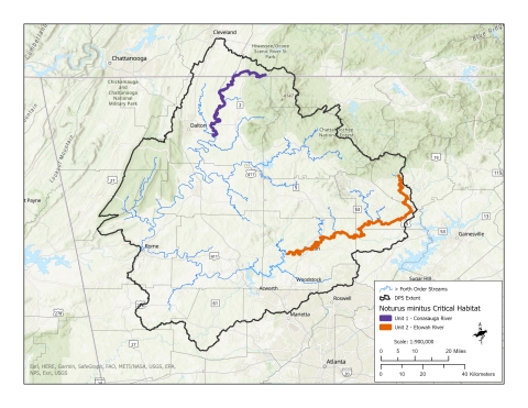
Final designation of critical habitat for the Upper Coosa River DPS of frecklebelly madtom with units, riparian ownership, and length of units.
Unit | Riparian Ownership | Stream Miles | Stream Kilometers |
1: Conasauga River | Private, Private Conservation Parcels, State Lands, Federal | 51.5 | 83 |
2: Etowah River | Private, Private Conservation Parcels, State Lands, Federal | 82.5 | 133 |
Q: What is critical habitat?
The Service has the authority to identify critical habitat when it proposes to list an animal or plant as endangered or threatened. Critical habitat is identified based on what an animal or plant needs to survive and reproduce by reviewing the best scientific information concerning a species’ present and historical ranges, habitat, and biology.
The designation of critical habitat helps ensure federal agencies and the public are aware of the habitat needs of the frecklebelly madtom and proper consultation is conducted by federal agencies when required by law.
The designation will have no impact on private landowners taking actions on their land that do not require federal funding or permits.
Q: What does a critical habitat designation do?
When an area is designated as critical habitat for a listed species, federal agencies are required to ensure that any action they fund, authorize, or carry out is not likely to result in the destruction of the habitat. This is carried out through consultation with the Service under Section 7 Section 7
Section 7 Consultation
The Endangered Species Act (ESA) directs all Federal agencies to work to conserve endangered and threatened species and to use their authorities to further the purposes of the Act. Section 7 of the Act, called "Interagency Cooperation," is the mechanism by which Federal agencies ensure the actions they take, including those they fund or authorize, do not jeopardize the existence of any listed species.
Learn more about Section 7 of the ESA. This only affects projects that require a federal permit or other actions funded or conducted by a federal agency.
The designation of critical habitat does not affect land ownership or establish a refuge, wilderness, reserve, preserve or other conservation area conservation area
A conservation area is a type of national wildlife refuge that consists primarily or entirely of conservation easements on private lands. These conservation easements support private landowner efforts to protect important habitat for fish and wildlife and major migration corridors while helping to keep agricultural lands in production.
Learn more about conservation area . A critical habitat designation also does not allow the government or public to access private lands, nor does it require implementation of restoration, recovery, or enhancement measures by non-federal landowners.
Q: What is a 4(d) rule?
For a threatened species, the Service may use flexibility provided under the ESA’s section 4(d) to tailor the take prohibitions to accommodate those actions that may provide conservation benefits for the species, referred to as a 4(d) rule. The ESA allows for 4(d) rules that are “necessary and advisable” for the conservation of the species. This targeted approach can reduce ESA conflicts by allowing some activities to continue that may benefit the madtom and do not significantly harm it, while focusing our efforts on the threats that slow species recovery. These customized protections of the ESA minimize regulatory burden while maximizing the likelihood of recovery of a threatened species.
Q: How does the 4(d) rule affect activities occurring in the frecklebelly madtom’s habitat?
The final 4(d) rule will provide exceptions to incidental take resulting from the following: channel restoration projects, streambank restoration projects, and activities carried out under programs like the Natural Resource Conservation Service’s (NRCS) Working Lands for Wildlife (WLFW) program or similar projects. Based on information the Service received during the comment period, an exception was added for silviculture practices and forest management activities that use state-approved best management practices.
Q: Where can I find the final listing, critical habitat, and 4(d) rule?
The complete listing rule can be obtained by visiting the Federal eRulemaking Portal: www.regulations.gov at Docket Number FWS–R4–ES–2020-0058.