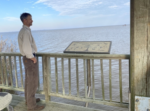
Swan Quarter, North Carolina – The observation deck midway along the causeway affords a spectacular view of Lake Mattamuskeet. A bald eagle alights on a cypress island that seemingly floats above the lake’s surface. The water sparkles like diamonds in the afternoon sun.
Yet it’s what you don’t see that’s perhaps most intriguing. And troubling.
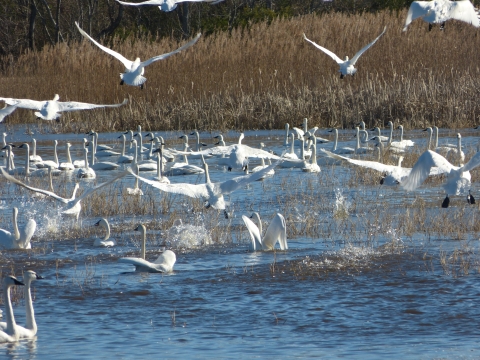
The water is cloudy. Sediment blocks the view of the shallow lake bottom only three feet below. The dirty water also keeps sunlight from helping wild celery, pondweed, and other grasses grow. Without vegetation, the tundra swans, snow geese, and northern pintails – for which Mattamuskeet is globally famous – may not come as often.
But the carp will.
And that’s another problem.
The invasive, voracious bottom-feeders muddy the waters. The migratory birds find even less to eat which poses a big problem for Mattamuskeet National Wildlife Refuge and its mandate to “remain a premier wintering area for ducks, geese, and swans on the Atlantic Flyway.”
And that’s, really, before taking account of the vagaries of climate change climate change
Climate change includes both global warming driven by human-induced emissions of greenhouse gases and the resulting large-scale shifts in weather patterns. Though there have been previous periods of climatic change, since the mid-20th century humans have had an unprecedented impact on Earth's climate system and caused change on a global scale.
Learn more about climate change and how the ever-rising waters will further harm one of the more ecologically unique corners of the country.
Now, though, federal, state and nonprofit groups are fighting the carp with hopes of rescuing the sick lake. Armed with a $1 million grant from the 2021 Bipartisan Infrastructure Law Bipartisan Infrastructure Law
The Bipartisan Infrastructure Law (BIL) is a once-in-a-generation investment in the nation’s infrastructure and economic competitiveness. We were directly appropriated $455 million over five years in BIL funds for programs related to the President’s America the Beautiful initiative.
Learn more about Bipartisan Infrastructure Law , the refuge has contracted with a Minnesota company to remove one million pounds of carp over the next year. Not only, hopefully, will the underwater grasses and tens of thousands of birds return to Mattamuskeet, but crappie, bass, herring, eel and blue crabs will flourish – to the delight of fishermen.
Getting rid of carp is the first (and least expensive) step towards a multi-million-dollar restoration, and re-plumbing, of the Mattamuskeet region. It’s also critical to the economic survival of one of the poorest, least inhabited regions of North Carolina.
“Lake Mattamuskeet has seen better days,” says Kelly Davis, a local landowner and N.C. Wildlife Resource Commission board member. “But Hyde County loves that lake. It’s not just the waterfowl; it’s the fish, the shorebirds, and the crabs. It’s the American eels that live in the lake and migrate to the Sargasso Sea to spawn. It’s the herring that move up and down the Atlantic seaboard yet come into Mattamuskeet to spawn. And it’s the tundra swans that fly all the way from Canada and the Great Lakes to Mattamuskeet. We have a resource of international value and we have to take care of it.”
‘A great, tumultuous crescendo’
Man’s been messing with Lake Mattamuskeet for centuries. Algonquian Indians, supposedly, named the lake which means “near marsh or bog,” or “dry dust,” depending on whose interpretation you prefer. Again, allegedly, the Native Americans set fire to the peat bogs between the Albermarle and Pamlico sounds which burned so long and so deep that huge, bowl-shaped depressions formed in the soil. (Other lore has it that giant meteors rained upon the coastal plain and gouged out Mattamuskeet and other lakes.) Rain, groundwater, and drainage filled up the bowls.
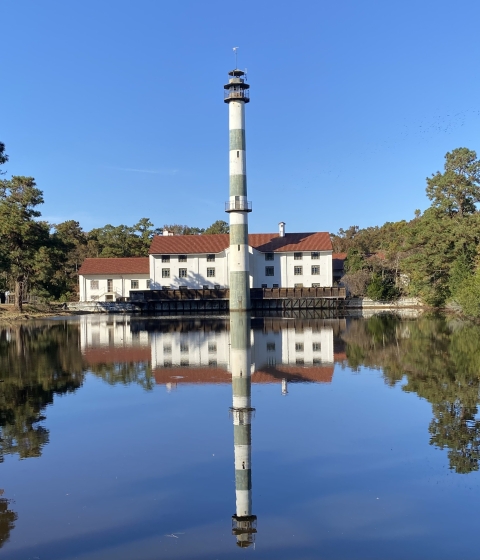
European settlers covetously eyed the lake and surrounding fields and forests as early as 1585. Enslaved people drained Mattamuskeet in 1837 by digging a five-mile canal to the Pamlico Sound. The lake shrunk by half to 55,000 acres with an average depth of four feet. A drainage district was created in 1909, more canals were dug, and a pumping station – the world’s largest – was built. The village of New Holland was laid out below the pump station with its distinctive 12-story smokestack. Trains brought in coal and took away corn, cotton, wheat, and other crops. The lake was drained three times between 1916 and 1926, yet, as Rachel Carson wrote in 1947, investors decided on “the eventual abandonment of the scheme as impractical and impossibly expensive.”
In 1934, the lake and environs were acquired by the federal government and the refuge was born. The Civilian Conservation Corps converted the pump station into the Mattamuskeet Lodge for hunters, birdwatchers, and partygoers with a dozen rooms and a grand dining hall. The smokestack was turned into an observation tower with commanding views of water and wildlife. (The lodge closed in 1974.)
“Magnificent though the swans are, the person who visits Mattamuskeet in midwinter is likely to come away with impressions of geese uppermost in his mind,” Carson, an aquatic biologist with the U.S. Fish and Wildlife Service, wrote in the fourth of her Conservation in Action pamphlets. “Throughout much of the day, their wings pattern the sky above you. Underlying all the other sounds of the refuge is their wild music, rising at times to a great, tumultuous crescendo, and dying away again to a throbbing undercurrent.”
Carp, though, were already a nuisance, kicking up dirt and killing the vegetation. Commercial fishermen deployed large gill nets to corral and extract carp. Striped bass were dumped into the lake to eat the fish. Water quality improved quickly. Vegetation returned and, by the mid-50s, covered about a third of Mattamuskeet.
All was seemingly well for 40 years. But the carp, and other culprits – sediment and algae blooms – fouled the waters. Farms and impoundments surrounding the lake are allowed to drain their fields into Mattamuskeet. Dirt from the fields rolls into the lake, gets stirred up by the wind, clouds the water, and blocks out the light the vegetation needs to grow. With the grasses unable to grow, blue-green algae, or cyanobacteria, flourishes further inhibiting the growth of aquatic vegetation. Rising seas fueled by the warming climate help to keep the 40,000-acre lake from draining, bottling up the poisonous waters.
In 2016, the state placed Mattamuskeet – one of the premier winter stops on the Atlantic Flyway -- on the list of impaired and threatened waters. A year later, refuge staff couldn’t find a single blade of vegetation in the 17-mile-wide lake. Fishing on the lake suffered as the grasses and the bass disappeared. (Fishing from the causeway for white perch and other sportfish, though, remains robust.)
The iconic tundra swans were hit hard, too. In 2008, an estimated 35,000 of the white-plumed, black-billed birds alighted on the lake, refuge, and surrounding farms, according to a mid-winter survey by the N.C. Wildlife Resources Commission. In 2017, only 18,000 were tallied. And duck harvests on the refuge are off maybe 40 percent with many of the refuge’s blinds empty on hunt days.
“You used to come across the causeway and all you’d see were swans – the lake used to turn white -- and ducks,” says refuge manager Kendall Smith while staring across the near-empty lake. “Now, most days, you don’t see any of those. But we’re hopeful we’ll see it again, one way or another.”
Capturing carp
Restoring Mattamuskeet started with biologists from the Service and the N.C. wildlife commission figuring out why the grass disappeared and, once the carp were pegged as the culprit, how it could be restored. They laid the scientific groundwork for the “watershed restoration plan,” the 2018 blueprint for the lake’s salvation prepared by the N.C. Coastal Federation. The plan listed three goals: protect Hyde County’s way of life; actively manage water levels; and restore water quality. Getting rid of carp was the refuge’s first objective.
The Service, in 2021, installed metal bars two inches apart at the tide gates along the canals leading to the Pamlico Sound to keep carp from entering the lake. Native fish, crabs, and eel can still bypass the gates. The state also stocks Mattamuskeet each year with bluegills which gobble up carp eggs and larvae.
In December, Smith joined state and private fisheries biologists for a day on the lake where they implanted radio telemetry tags into 39 “Judas” carp. The Service contracted with WSB, a Minnesota-based engineering and environmental firm, to rid Mattamuskeet of thousands of carp. A series of receivers positioned around the lake will track their movements. And, since carp typically travel in bunches, the Judas carp should betray their location. Seine nets, electrofishing, and other removal techniques will be deployed to capture the carp.
Tony Havranek, fisheries director for WSB, said he hopes to sell some of the captured carp to wholesalers, restaurants, or fishpond owners. Some might go for hog feed or fertilizer. The rest will be composted, probably on the refuge.
“There's a market out there somewhere for carp,” Havranek says.
The federal fishing expedition will capture thousands of Mattamuskeet’s carp. Smith, though, says that the reduction, combined with the bluegill stockings, tidal gate deterrents, and rest of the restoration plan should keep the carp population under control.
“We can’t get them all, but we’ll at least get them below a manageable level,” he says. “It's all part of the bigger picture, for sure. We’ll make it successful one way or another.”
‘Rome wasn’t built in a day’
The main source of Mattamuskeet’s tainted water, though, comes from the land. And, with more water and sediment flowing from the fields into the lake, flooding is perhaps the most nettlesome long-term problem bedeviling the lake.
Mattamuskeet “is no longer a ‘natural lake’ due to extensive hydrologic modifications that have occurred over the past 200 years,” the Coastal Federation says in its restoration plan. In addition to all the farm ditching and canal digging, the creation of the nearby Atlantic Intracoastal Waterway a century ago also impacts the natural flow of water. The low-lying Albermarle-Pamlico watershed had long relied on gravity to move water off the land, through the lake, and into the sounds. Tidal gates along the four outlet canals are supposed to allow the lake to drain, keep surrounding farms from flooding, and prevent saltwater from inundating Mattamuskeet.
The Coastal Federation, though, points out two “alarming trends” that boost flooding. Rising seas – the waters off Swan Quarter have gone up a foot the last century and could rise another foot by 2050 – keep much of the water from leaving Mattamuskeet as well as adjoining farms and impoundments. And sediment, increasingly, clogs the canals.
The state set aside $10 million last year to dredge the seven-mile-long Outfall Canal. The Coastal Federation also received $16.9 million last year from the U.S. Department of Agriculture for an array of water-quality improvements. One-thousand acres of agricultural lands will be restored to wetlands to filter runoff. Pump stations will be built to reduce drainage into Mattamuskeet. And farmers will be enlisted to better control runoff into the lake.
“It’s going to take a whole ecosystem approach to fixing Mattamuskeet,” says Chris Smith, a fisheries biologist with the state’s wildlife commission. “It’s also going to take help from locals and farmers and everybody else. Some people envision this as a quick resolution. But the old saying, ‘Rome wasn’t built in a day,’ applies here.”

