
Waterfowl hunting will be allowed on the Clarks River managed waterfowl units and designated areas by a quota draw hunt. The units and areas will be closed to all entry, with the exception of the drawn permit holder and their guests on drawn hunt days only. Drawn hunt days will be during the statewide waterfowl season, except during modern rifle and muzzleloader deer seasons. Descriptions and maps of each area can be found below.
Quota hunt applications will be accepted starting September 1st and must be completed no later than October 15th. To apply, visit Clarks River National Wildlife Refuge's RecAccess Site. For more information on the quota hunt and other refuge regulations, please see the refuge Public Use Regulation Brochure.
Mallard Point Unit (Marshall County, KY)
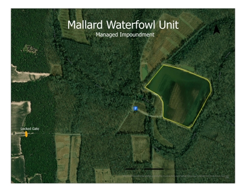
- Access and Parking: Easy to Moderate. Gravel road for access and parking.
- Approximate Size: 29 acres (flooding weather dependent; 95% of land has potential to flood; no permanent water)
- Primary Habitat: open field/native plants (moist soil)
- Water levels managed through levees and water control structures. Variable water depths (deep and shallow; 1 inch to 12 feet)
- Blinds are not present; Hunting cover options are limited; Mostly natural non-woody vegetation.
- Hunt Days: Saturday and Sunday until 12 noon.
- Key for gate required; Distance from gate to hunt area approximately 1.5 miles.
- Boat use permissible; no designated/improved launch area
- Latitude: 36°55'45.91"N Longitude: - 88°27'4.20"W
Redhead Unit (Marshall County, KY)
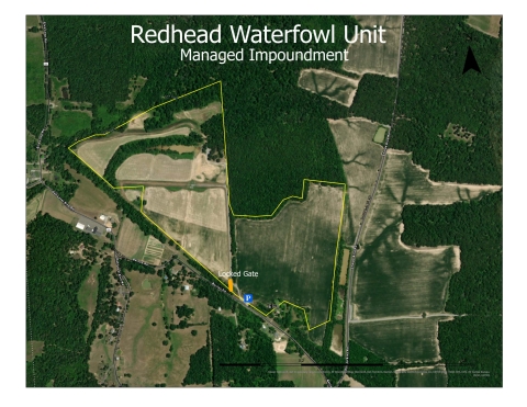
- Access and Parking: Easy to Moderate. Gravel road for access and parking.
- Approximate Size: 81 acres (flooding weather dependent; 60% of land has potential to flood; minimum permanent water)
- Primary Habitat: open field/native plants (moist soil)
- Water levels managed through levees and water control structures; Variable water depths (deep and shallow; 1 inch to 6 feet)
- Blinds not present; Hunting cover limited, natural vegetation including trees.
- Hunt Days: Tuesday and Wednesdays until 12 noon.
- Key for gate optional based on hunter preference. Distance from gate to hunt area approximately ¼ mile.
- Boat use permissible; no designated/improved launch area
- Latitude: 36°55'59.72"N Longitude: -88°28'37.76"W
Wolfe Unit (Marshall County, KY)
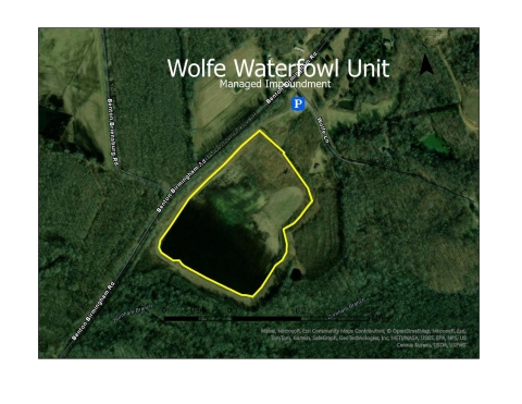
- Access and Parking: Moderate. Gravel parking area. Distance from parking area to lower portion of unit approximately ¼ mile
- Approximate Size: 17 acres (flooding is weather dependent; 80% of land has potential to flood; no permanent water)
- Primary Habitat: open field/native plants (moist soil)
- Water levels managed through levees and water control structures. Variable water depths (deep and shallow; 1 inch to 4 feet)
- Blinds not present; Cover options include weeds, grass and small trees on one side of unit
- Hunt Days: Tuesday and Wednesdays until 12 noon.
- No gate; distance to hunt area approximately ¼ mile
- Boat use permissible; no designated/improved launch area
Latitude: 36°52'15.12"N Longitude: - 88°19'28.42"W
Wood Duck Natural Area (Graves County, KY)
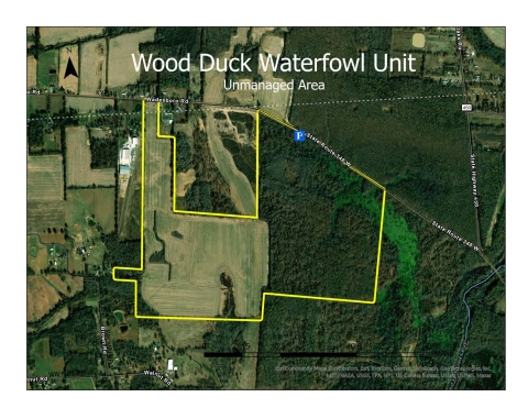
- Access and Parking: Limited
Approximate Size: 306 acres (flooding weather dependent; 60% of land has potential to flood; permanent water present)
- Primary Habitat: Seasonally flooded Forest and Cropland
- No active management or infrastructure
- Blinds not present; cover options are natural vegetation including trees
- Hunt Days: Saturdays and Sundays until 12 noon
- No gate; distance to hunt areas variable; must hunt at regulated distance from roadway
- Boat use permissible; no designated/improved launch area
- Latitude: 36°56'14.82"N Longitude: - 88°33'24.47"W
Teal Natural Area (Marshall County, KY)
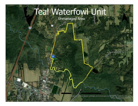
- Access and Parking: Limited.
Approximate Size: 328 acres (flooding weather dependent; 90% prone to flooding; permanent water present)
- Primary Habitat: Forest and scrub/shrub emergent wetlands
- No active management or infrastructure
- Blinds not present; cover options are natural vegetation including trees
- Hunt Days: Saturdays and Sundays until 12 noon
- No gate; distance to hunt areas variable
- Boat use permissible; no designated/improved launch area
- Latitude: 36°52'35.92"N Longitude: - 88°20'24.46"W
If you have additional questions, please contact the refuge office at 270/527-5770.


