Whether they run, swim or fly, wild animals need to move to complete their life cycles. We call their routes wildlife corridors. These can span anywhere from a stretch of river to a whole continent.
National wildlife refuges are vital to connecting and maintaining safe wildlife corridors for birds, fish and mammals. The more crowded and developed our world becomes, the more critical these pathways become.
Large mammals, such as elk, mule deer and pronghorn, may travel hundreds of miles between lowlands where they winter and higher summer ranges.
As new roads and subdivisions create barriers to traditional feeding and breeding grounds, wildlife refuges sometimes fill in the gaps.
Every year, thousands of elk descend from high country to winter at National Elk Refuge in Wyoming. Fence breaks known as “elk jumps” built into the refuge’s western boundary let elk enter the refuge but limit their leaps out near highways, protecting both wildlife and people.
But barriers and hazards multiply with the miles animals travel. Wildlife refuges partner with neighboring landowners to ensure safe passage for wildlife across the mosaic of public and private lands between refuges. A few years ago, some refuges and partners got a government assist.
In 2019 the Department of the Interior directed $2.1 million in grants to state and local partners in several Western states to conserve habitat corridors for elk, mule deer and pronghorn.
In Nevada, Partners for Fish and Wildlife cheered the announcement, noting that planned improvements to migration corridors (such as controlling invasive grasses, planting sagebrush sagebrush
The western United States’ sagebrush country encompasses over 175 million acres of public and private lands. The sagebrush landscape provides many benefits to our rural economies and communities, and it serves as crucial habitat for a diversity of wildlife, including the iconic greater sage-grouse and over 350 other species.
Learn more about sagebrush , and improving or removing fences) also benefit non-migrating species that depend on the sagebrush ecosystem.
See a 3-D visualization of one deer’s 242-mile migration.
Wildlife refuges also help songbirds and waterfowl survive by supporting their migration paths. Spaced at intervals below the nation’s four main north-south flyways, refuges provide vital food and rest stops for birds worn out by their arduous flights.
In the nation’s heartland, where half of the country’s ducks and geese are concentrated, wildlife refuges serve as stepping stones to help birds weather their journeys. Working in tandem with private landowners and state conservation areas, refuges offer birds food and water and cover.
Today, these conservation islands may be even more critical to bird survival than in the past, as surrounding habitat is lost to farmland, energy production and urban development, says James Dubovsky, former Central Flyway representative for the U.S. Fish and Wildlife Service’s Division of Migratory Bird Management.
Loess Bluffs National Wildlife Refuge in northwest Missouri, where the Central Flyway and Mississippi Flyway converge, manages its wetlands to meet birds’ needs.
“We draw down water levels in spring to expose mudflats so migrating ducks and shorebirds can feed on small clams and invertebrates,” says former manager Lindsey Landowski. “In the summer, we encourage the growth of moist-soil plants like millet, toothcup and smartweed that ducks like. Arrowhead is a favorite for trumpeter swans. In August, September and October, we re-flood some of the wetlands to attract shorebirds and dabbling ducks. Blue-winged teal and green-winged teal are the first to appear, followed by Northern pintails, gadwalls, mallards and snow geese.”
In the far north, Yukon Flats and Yukon Delta and Arctic National Wildlife Refuges in Alaska provide vital nesting grounds for many bird species.
At refuges nationwide, U.S. Fish and Wildlife Service biologists collect data used to set duck and geese hunting at safe levels each year to ensure waterfowl species continue to thrive.
Sometimes, the best way to maintain viable wildlife corridors is to call in the engineers.
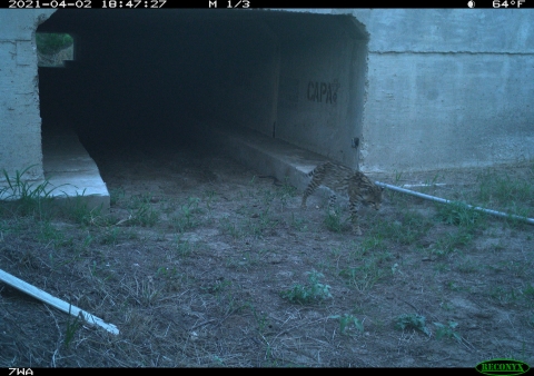
At the southern tip of Texas, home to the country’s last two remaining populations of endangered ocelots, development has made roads a pinch point for the rare and secretive cats. As farming and construction carve up the animals’ thorn scrub habitat, ocelots are being forced onto roads and into the path of cars.
Since 2005 Laguna Atascosa National Wildlife Refuge and partners have built 14 road underpasses to help ocelots and other small mammals move safely in search of territory and mates. Two more bridge structures are scheduled for completion by 2023, making area roads safer for hundreds of motorists, too.
Monitoring cameras show coyotes, bobcats, raccoons and possums using the wildlife tunnels, even those still under construction. Recently, ocelots have been observed using the underpasses. Monitoring will likely continue for several years.
U.S. Fish and Wildlife Service zone biologist Mitch Sternberg hopes the underpasses will help improve ocelots’ odds of survival by linking the ocelot population at Laguna Atascosa Refuge to nearby refuge habitat that the cats used to inhabit.
“Our mission here is wildlife sustainability,” says Sternberg. “We want to maintain public wildlife recreation opportunities and maintain the integrity of the area for future generations of Americans.”
To complete their life cycles, fish need clear passage through connected habitat, too.
The U.S. Fish and Wildlife Service is helping by removing or replacing some of the country’s estimated 6 million man-made fish barriers, such as old culverts and dams.
Over the last four years, the Service and its partners have reopened almost 4,500 stream miles and more than 15,000 acres of wetland habitat to fish passage fish passage
Fish passage is the ability of fish or other aquatic species to move freely throughout their life to find food, reproduce, and complete their natural migration cycles. Millions of barriers to fish passage across the country are fragmenting habitat and leading to species declines. The U.S. Fish and Wildlife Service's National Fish Passage Program is working to reconnect watersheds to benefit both wildlife and people.
Learn more about fish passage . Much of this work benefits fish and other species on refuges.
For example, a restoration at Tualatin River National Wildlife Refuge, near Portland, Oregon, is expected to improve conditions for cutthroat trout and Coho salmon. Both species swim upstream to spawn in spring. But many fail to reach their spawning grounds because they can’t clear the refuge’s Chicken Creek, ditched and straightened for farming decades ago by the refuge’s prior owners.
In 2019 the refuge began work on a major project to return the creek to its historic meandering path and natural streambed. Workers also removed old metal water control structures that posed obstacles to fish. In 2021 the refuge took the restoration a few steps further by removing the center dike road, reconnecting the final upper portion of the creek, filling the old ditch, and installing two free-spanning bridges.
“We anticipate the project will greatly increase fish passage through the refuge and increase fish habitat also,” said former refuge manager Larry Klimek. “A lot of what we’re doing at the refuge is protecting the Tualatin River wildlife corridor wildlife corridor
To maintain healthy species populations and ecosystems, fish and wildlife need the freedom to move and migrate. As habitats and migration routes are affected by climate change and fragmented by roads, fences, energy development and other man-made barriers, wildlife struggle to reach necessary areas to feed, breed and find shelter. A wildlife corridor is a piece of undeveloped land connecting two habitats so wildlife can move safely between them.
Learn more about wildlife corridor for fish and land species.”
Insects and other plant pollinators also need connected land corridors to feed and rest along their air journeys.
Every spring and fall, monarch butterflies migrate up to 3,000 miles between their overwintering sites in Mexico and California and their breeding areas up north. On their way south, they stop to feed on milkweed and other nectaring plants. Back north, monarch larvae feed exclusively on their host plant milkweed. But milkweed and other nectar sources are shrinking because of increased mowing, herbicide use and development.
National wildlife refuges are working with partners and private citizens to encourage the planting of milkweed in monarch waystations.
You can help monarchs by planting a butterfly garden in your backyard or school.
Geospatial technology is revealing more about the travels of some elusive animals, such as the Canada lynx. That knowledge may help Alaska refuges conserve this iconic species, as scientists study how lynx are responding to pressures such as trapping, habitat change and threats to landscape connectivity.
The map above shows the approximate movement paths (lines connecting dots) and home ranges (colored polygons) of 12 lynx captured and radio-collared on or near the northern third of Kanuti National Wildlife Refuge (darker green shading) in March/April 2018. The most notable movement was of one lynx (turquoise) that was collared south of Bettles, Alaska, and traveled northwest into the Brooks Range, only to return to the refuge 10 days and 85 miles later.
For years now, researchers at Kanuti Refuge and partner sites have been tracking lynx movements in relation to ups and downs in the snowshoe hare population. Lynx prey primarily on snowshoe hares, so the two species’ populations rise and fall in closely linked cycles.


