Location


States
TexasEcosystem
River/streamIntroduction
The Pecos River is the largest tributary of the Rio Grande and flows 926 miles south-southeast through eastern New Mexico and western Texas. The Pecos River Basin covers approximately 44,000 square miles and can reach elevations more than 12,000 feet above the North American Vertical Datum of 1988 (NAVD 88). Over the years, increased salinity of the Pecos River has become a major concern among water users and water managers.
Salinity in the Pecos River can increase by two processes. The first process is the addition of dissolved solids by an external source by the discharge of saline groundwater and irrigation return flows. The second process is the removal of fresher water by diversion for irrigation or evapotranspiration.
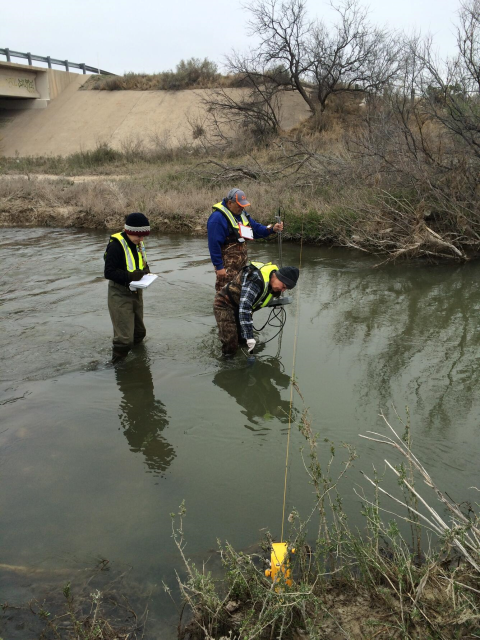
Although many studies have contributed to the understanding of salinity increases in the basin, managers and researchers identified the need for consistent sampling of the same constituents at the same sites along the Pecos River. This data gap reduced the ability to analyze long-term salinity changes and identify sources of high salinity within the basin. To fill in this data gap, the U.S. Geological Survey (USGS) collected water-quality and streamflow data from Santa Rosa Lake, New Mexico to the confluence of the Pecos River and the Rio Grande, Texas, in February of 2015. The streamflow data were used to complete a gain-loss study at a finer resolution to help locate areas or reaches where water was being added at the Pecos River. This study focused on identifying and documenting areas of the addition of dissolved solids from external sources.
Key Issues Addressed
The Pecos River is an important water source for livestock, irrigation, recreation, and wildlife habitat. It also provides inflows to the Amistad Reservoir, supplying drinking water to downstream cities and into Mexico. While the flow of the Pecos River has declined from increased water demand and climate variability, salinity levels have increased. The average dissolved solids concentration of the water from the Pecos River entering Texas is approximately 6,000 mg/L. Fresh water is 1000 mg/L and slightly saline water is 3,000 mg/L. High salinity levels can have multiple impacts including degradation of water quality, reduction of usable water, loss of wildlife habitat, and reduction in crop yield. By understanding areas of increased salinity levels, water management alternatives can be implemented, such as developing approaches to better control them, or potentially intercepting the source of salinity before it impacts surface-water supplies.
Project Goals
- Compile research and data available from Santa Rosa Lake, New Mexico to the confluence of Pecos River and Rio Grande, Texas to identify critical data gaps in the Pecos River Basin
- Identify and understand how specific areas are contributing to elevated salinity in the Pecos River, especially from groundwater discharge
- Assess how salinity of the Pecos River has changed over time
Project Highlights
Additional Ideas: As part of the literature review, USGS documented scientific recommendations that were made by researchers working in the Pecos River Basin, such as salinity control options, water-quality sampling suggestions, and locations of data gaps.
- Understanding the Geology: The Pecos River Basin is underlain by formations such as the San Andres, Salado and Rustler which contain salt-bearing rocks that dissolve as groundwater migrates through them and subsequently discharges to the Pecos River. To aid in the understanding of how the underlying geology may contribute to the salinity of the Pecos River in the study area, the horizontal extent of and depth to the base of the geologic units that underlie the study area were mapped.
- Learning from Historical Water-Quality Data: Available water-quality data were downloaded from various state and federal agencies, compiled into one location, and reviewed for quality control and assurance by verifying that the data met specific criteria. This was important because it was the first time data from other basin studies were collected, which allowed managers to understand the data gaps.
- Assessing Salinity: The subreaches of the Pecos River between Acme, New Mexico and Artesia, New Mexico, and between Orla, Texas, and Grandfalls, Texas were identified as areas of increasing salinity. The literature review identified potential sources of salinity inputs including:
- Sinkhole springs discharging to the Pecos River
- The Bitter Lake National Wildlife Refuge inflow to the Pecos River
- Inflow from the Rio Hondo
- Outflow from Lea Lake at Bottomless Lakes State Park
- Springs discharging into the Pecos River at Malaga Bend area
- Salt Creek downstream from Red Bluff Reservoir
- The area near the Horsehead Crossing ford on the Pecos River
- Salinity Source Challenges: WIn addition, water quality sampling results indicate mixing of different waters along these reaches may be occurring from either groundwater or other surface-water features. The mixing of water hampers the ability to effectively define a source and these areas may need further investigation to determine if and where the mixing of water may be occurring and whether that factor is affecting salinity in the Pecos River.
Lessons Learned
Over time multiple agencies collected water-quality data in the Pecos River Basin. These sampling efforts were not coordinated so there was a lack of consistent sampling methods, hindering the ability to effectively analyze long-term changes in water quality that may help with the understanding of how salinity has changed over time and identifying the sources of salinity. Typically, water-quality data is collected at select locations providing a snapshot of the conditions at that location and specific time period as directed by the source agencies’ priorities for their collection efforts. What would be beneficial is if all of the agencies that collect water-quality data throughout the Pecos River Basin consistently sampled for the same constituents and coordinated their sampling events which would provide a comprehensive comparison over time.
Community outreach and stakeholder meetings helped build a relationship with the residents and local agencies. Working with local agencies was imperative as they understood the system and the issues more thoroughly than the researchers. Increased communication and collaboration helped researchers plan basin tours, schedule samplings, and assisted with gaining access to remote or privately owned sites and areas. They also provided reservoir release schedules, so researchers were able to sample sites before any water was released.
Next Steps
This study will be included in the U.S. Army Corps of Engineers Pecos Watershed Assessment to identify possible salinity control projects within the Pecos River Basin
Funding Partners
Resources
- Pecos River Basin Salinity Assessment
- Pecos River Basin salinity assessment, Santa Rosa Lake, New Mexico, to the confluence of the Pecos River and the Rio Grande, Texas, 2015
- Water Quality, Streamflow Gain Loss, Geologic, and Geospatial Data Used in the Pecos River Basin Salinity Assessment from Santa Rosa Lake, New Mexico to the Confluence of the Pecos River and the Rio Grande, Texas, 1900-2015
Contacts
Natalie A. Houston, Hydrologist, U.S. Geological Survey: nhouston@usgs.gov
CART Lead Author
Deanna Morrell, Program Analyst, Bureau of Reclamation: dmorrell@usbr.gov
Suggested Citation
Morrell, D., P. (2021). “Identifying Areas of High Salinity in the Pecos River Basin.” CART. Retrieved from https://www.fws.gov/project/identifying-areas-high-salinity-pecos-river-basin.


