

What We Do
On this page you can find information about what we do:
- Habitat Management
- Habitats
- Management Tools (water, equipment, fire, research etc)
- Conservation and Partnerships
- Comprehensive Conservation Plans
- Private Lands Programs
Conservation Easements
Partners for Fish and Wildlife Program
- National Wildlife Refuge Improvement Act
- Law Enforcement
- Rules & Policies
HABITAT MANAGEMENT
At the Sacramento National Wildlife Refuge Complex, wetlands, uplands and riparian riparian
Definition of riparian habitat or riparian areas.
Learn more about riparian forests are manipulated through a variety of management techniques (mechanical, biological, and chemical) to promote diversity of high quality habitats (food resources). Management activities are guided and tracked by each refuge's annual Habitat Management Plan. These plans identify the specific physical attributes, habitat objectives, and species needs for every single pond and field of the refuge. Each year the plans are updated to specify the necessary management activities to maintain or improve the habitat of each unit.
Habitats
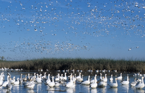
The Sacramento NWR Complex provides essential habitat for a great diversity of wildlife, particularly migratory birds of the Pacific Flyway. Approximately 95% of the historic wetlands, riparian areas, and grasslands in the Central Valley have been destroyed or modified. The Complex maintains nearly 70,000 acres of wetland, upland and riparian habitats.
Seasonal Wetlands
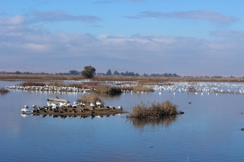
Seasonal wetlands make up the majority of the refuges' wetland habitat. They are flooded from fall through spring, and then are dry from late spring through summer. When ponds are drawn down in the spring, seed-producing plants germinate and grow on the moist pond bottoms. The seeds and invertebrates these ponds produce become available to waterfowl and other wetland species when they are flooded in the fall. Seasonal wetlands provide important resting and feeding habitat for waterfowl, shorebirds, egrets, herons, raptors and other wetland-dependent wildlife from fall to spring. Common plants include cattail, hardstem bulrush, alkali bulrush, and swamp timothy.
Irrigated Seasonal Wetlands
Some seasonal wetlands (described above) receive an irrigation during the spring or summer months in order to increase seed and vegetative production. Irrigations can last for a few days or over a month, depending on weather conditions and plant response. Shorter irrigations can enhance smaller stature plants, like swamp timothy, while longer irrigations can bring taller plants, such as watergrass and smartweed, to full maturation. Other plants that also respond with vigorous growth include sprangletop, spikerush, Bermuda grass, and joint grass. Because of the high seed production, irrigated seasonal wetlands have the highest waterfowl use, but tend to have decreased use by shorebirds due to the taller and denser plant structure.
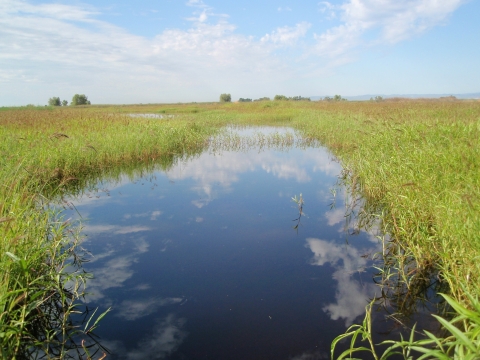
Permanent/Semi-Permanent Wetlands
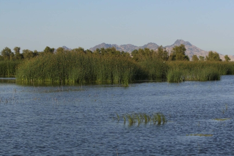
Permanent wetlands are flooded year-round and provide a water source that is valuable to resident wildlife, especially during the summer when most of the seasonal wetlands are dry. Semi-permanent wetlands are flooded from fall through summer, and are dry for a short window in late summer so that plant germination and nutrient recycling can occur. During the summer, when flooded habitat is scarce, these ponds provide nesting areas for resident waterfowl and other wildlife. During the fall and winter, they add to the important resting and feeding areas on the refuge. Characteristic plants include cattail, hardstemmed bulrush, burhead and sago pondweed.
Riparian Areas

Riparian areas tend to grow in linear areas along the edges of rivers, creeks, and waterways and can characterized by the thick growth of trees and shrubs. This scarce waterside habitat supports a great diversity of wildlife. It is heavily used by neo-tropical migrant bird species such as the yellow-billed cuckoo, black-headed grosbeak, spotted towhee and dozens of songbird species. It also provides important breeding habitat for colonial nesting egrets and herons, as well and raptors, such as hawks, eagles and owls. Cottonwoods, valley oaks, sycamores, willows, box elders, elderberry, and wild rose are common plants found in riparian areas.
Uplands/Grasslands
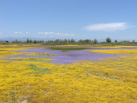
Upland areas include a mixture of grasslands and vernal pool/alkali meadow habitats. Many of the grassland areas have been restored to native grasses and wildflowers. In areas with more alkaline (salty) soils, rainwater tends to naturally puddle in depressions and create what are referred to as "vernal pools". Salt-tolerant native plants grow well in these alkaline areas. In the spring, these areas produce a carpet of protein-rich grass shoots and vernal pools are often filled with invertebrates, providing an important food source for waterfowl and shorebirds that are preparing for spring migration. During the spring and summer months, they provide nesting habitat for ducks, pheasants, meadowlarks, burrowing owls, bitterns, and northern harriers. In the winter and spring, annual grasses provide food for geese, coots, and wigeon. They also support significant numbers of insects, rodents, and reptiles which in turn are important forage items for raptors and birds. Goldfields, downingia, and popcorn flowers bloom brilliantly on the edges of the vernal pools in late spring. Other plants include: saltgras
Management Tools

Tools that the Complex uses for Habitat Management include:
• Water management (timing, depth, duration)
• Mechanical control (mowing, disking)
• Biological control (grazing)
• Chemical control (herbicide treatments)
• Prescribed burning
• Habitat restoration
• Monitoring and Research
Water Management

Water management is probably the most important tool the refuge has for maintaining high quality wetland habitat. By controlling the timing, depth and duration of water on each wetland, the refuge can manipulate the production of desirable or undesirable wetland plants. Water management is also critical in providing the proper habitat to specific species at different times of the year. For example, tricolored blackbirds needs dense stands of flooded cattail during the summer months for their nesting colonies, and shorebirds need shallow open wetlands in the spring and fall when they migrate through the Valley. In general, refuge flooding regimes are designed to mimic historic wetland availability in the Sacramento Valley.
Physical, Biological and Chemical Control
Each new year is accompanied by new changes in vegetative growth. Some of this vegetation is beneficial, providing nesting/escape cover or food resources, and some is undesirable and displaces desirable vegetation without any benefits. Vegetation control is necessary for a wide variety of reasons, including: maintaining biodiversity, enhancement of desirable species (for food and cover), reduction of undesirable species, preparation for habitat restoration projects, reduction of mosquito breeding habitat, and maintenance of safety zones around facilities to communities and assets at risk of wildfire. A variety of techniques are used depending on the habitat type, plant species, and resource objectives. Mechanical techniques, such as mowing and disking can improve loafing habitat, remove weedy species before seed is produced, kill perennial weeds, or improve seed beds for beneficial plants (kind of like tilling your garden). Biological techniques are used to set back native vegetation and to control weedy species, like grazing native grasslands to reduce thatch buildup so new grass shoots can grow each spring, or using beetles to eat invasive Klamathweed. Chemical control (herbicide) is used when other mechanical or biological techniques are ineffective, like when a new and highly invasive species invasive species
An invasive species is any plant or animal that has spread or been introduced into a new area where they are, or could, cause harm to the environment, economy, or human, animal, or plant health. Their unwelcome presence can destroy ecosystems and cost millions of dollars.
Learn more about invasive species is detected and quick control is critical, or for certain persistent species like pepperweed that have a 10 foot taproot make it impossible to otherwise eradicate.
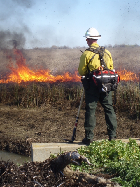
Prescribed Burning
A prescribed burn prescribed burn
A prescribed burn is the controlled use of fire to restore wildlife habitat, reduce wildfire risk, or achieve other habitat management goals. We have been using prescribed burn techniques to improve species habitat since the 1930s.
Learn more about prescribed burn is a controlled burn that is pre-planned by refuge managers in a specific area for a specific resource objective. Prescribed fires may be used to reduce hazard fuels, restore natural processes and vitality of ecosystems, improve wildlife habitat, remove or reduce non-native species, and/or conduct research. They are often used in conjunction with other management tools such as grazing, mowing, and herbicide applications.
Prescribed burns are used in wetlands to control invasive species, for example burning jointgrass during the summer, or to stimulate desirable species, such as burning rank cattail and bulrush over water to allow for fresh new growth. Fire lines and buffers are disked around the burn area to increase controllability. The firing pattern allows for an avenue or direction of escape for wildlife. Follow-up disking is often used to ensure that roots of target species (i.e. hard-stemmed bulrush, cattail, jointgrass, etc.) are killed and enhance germination of desirable species. The result is a desirable mix of vegetation species, stature are more productive and reduces the risk of life and property from larger more destructive wildfires. The frequency of burning wetland units depends on habitat type, vegetation species composition, soil type, and tendency for growth.
Prescribed burns in grasslands, alkali meadows, and vernal pools are used to reduce invasive species and stimulate native plant species. Resource benefits include maintaining biodiversity (especially native plant communities and the wildlife they support), providing browse for waterfowl, control of invasive species, and removing rank thatch to allow for new growth in native grass restoration areas. These burns may occur at any times of the year, depending on specific objectives and condition of the habitat.
The Fire Crew
The California North Central Valley Fire Management Zone is headquartered at the Sacramento National Wildlife Refuge Complex in Willows, California. The program provides fire management services for the Sacramento NWR, Delevan NWR, Colusa NWR, Sutter NWR, Sacramento River NWR, Stone Lakes NWR, Red Bluff Field Office, Coleman National Fish Hatchery (NFH) and Livingston Stone NFH. The fire program emphasizes fire suppression, prevention, hazardous fuels reduction and prescribed fire. The Zone's fire management mission is to provide a team approach to safe, efficient, and professional fire management program while protecting and enhancing fish and wildlife habitat.
The Fire Management Staff is stationed at the Sacramento NWR. The staff includes: Fire Management Officer, Fire Engine Operators and several Temporary Firefighters.
The fire program operates with two Type-3 engines, one Type-6 fire engine and one water tender. The fire staff participates on interagency incident management teams, refuge fire responses, off-unit assignments across the Nation, interagency prescribed fire operations and interagency training assignments. The zone treats an average of 1,200 to 1,800 acres per year for a range of resource objectives including hazardous fuels reduction, community protection and habitat enhancement.
The fire staff is augmented by a strong contingent of collateral duty fire qualified personnel. Over 10 Complex staff members from biologists, law enforcement, equipment operators and refuge managers assist with wildfire support and prescribed fire operations.
Monitoring and Research
Wildlife and plant monitoring, along with other research activities provide valuable data to help refuge staff evaluate past habitat management actions and refine future management needs.
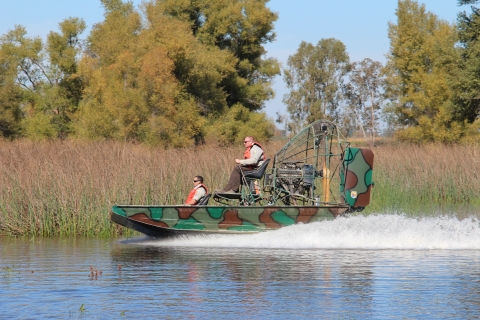
Refuge biologists conduct long-term monitoring of wildlife populations, wildlife diseases, wetland vegetation, and rare plants to help guide annual management decisions. Bird diseases that most frequently affect the waterfowl on the Complex include avian cholera, avian botulism, and lead poisoning. These diseases cannot be passed to humans. Dying birds are monitored and dead birds removed with airboats to stop the disease cycle. Click here to find out more about the refuge's wildlife surveys.
Partnerships with other agencies, non-profit research partners, and universities allow for more in-depth management-oriented research that helps support and inform not only management at the refuge level, but also at a landscape, flyway, and international level as well.
CONSERVATION AND PARTNERSHIPS
The Complex is involved in many conservation endeavors, including Comprehensive Conservation Plans, Private Landowner Programs, and the National Wildlife Refuge System Improvement Act.
Comprehensive Conservation Plans
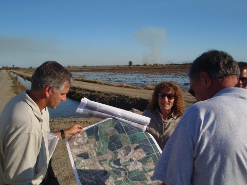
Refuge Planning: National Wildlife Refuge planning sets the broad vision for refuge management and the goals, objectives, strategies, and actions required to achieve it. Planning ensures that each refuge meets its individual purposes, contributes to the Refuge System’s mission and priorities, is consistent with other applicable laws and policies, and enhances conservation benefits beyond refuge boundaries.
Comprehensive Conservation Plans (CCPs) are the primary planning documents for National Wildlife Refuges. As outlined in the National Wildlife Refuge System Administration Act, as amended, the U.S. Fish and Wildlife Service (Service) is required to develop CCPs that guide refuge management for the next 15 years. CCPs articulate the Service’s contributions to meeting refuge purposes and the National Wildlife Refuge System mission. CCPs serve as a bridge between broad, landscape-level plans developed by other agencies and stakeholders and the more detailed step-downs that stem from Refuge CCPs.
CCP: Wildlife Management Areas
The Final CCP and Environmental Assessment for the Butte Sink, North Central Valley, and Willow Creek-Lurline Wildlife Management Areas was completed in 2020. These WMAs include both Service-owned lands and private lands that are protected with conservation easements. This CCP includes the following WMAs:
• Butte Sink
• Willow Creek-Lurline
• Steve Thompson North Central Valley
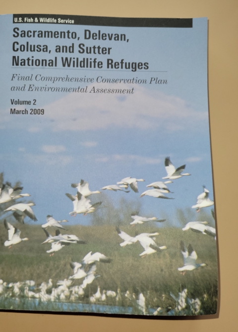
CCP: Sacramento, Delevan, Colusa and Sutter NWRs
The Final CCP and Environmental Assessment for Sacramento, Delevan, Colusa, and Sutter NWRs was completed in March, 2009 and includes the following refuges:
• Sacramento NWR
• Delevan NWR
• Colusa NWR
• Sutter NWR
CCP: Sacramento River NWR
The Final CCP and Environmental Assessment for the Sacramento River NWR was completed in July, 2005. This CCP includes the Sacramento River NWR.
Step-down Plans
CCP step-down plans guide refuge-level programs for:
- Conserving natural resources (e.g., fish, wildlife, plants, and the ecosystems they depend on for habitat);
- Stewarding other special values of the refuge (e.g., cultural or archeological resources, wilderness, wild and scenic rivers, etc.);
- Engaging visitors and the community in conservation, including providing opportunities for wildlife-dependent recreation.
Like CCPs, step-down plans contribute to the implementation of relevant landscape plans by developing SMART (Specific, Measurable, Achievable, Relevant, and Time-bound) objectives, strategies, implementation schedules, and decision support tools to fulfill refuge visions and goals. This ensures that refuges are managed in a landscape context and that conservation benefits extend beyond refuge boundaries.
PRIVATE LANDS PROGRAMS
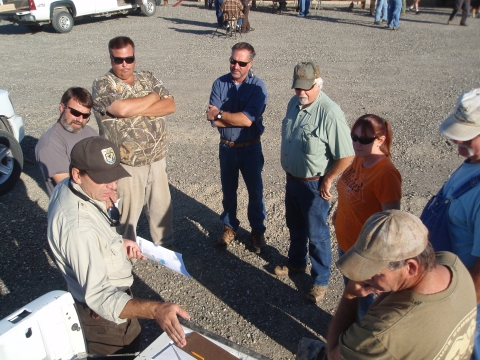
Our Private Lands staff works with private landowners, partnering agencies and conservation groups to provide information and assistance for the preservation and enhancement of a variety of habitats throughout the Sacramento Valley.
The Private Lands Program was initiated at Sacramento NWR Complex in 1981 to protect private wetlands in the Sacramento Valley for the benefit of migratory birds and other wetland dependent wildlife. Initially, the focus of the private lands staff was implementing the Service's Conservation Easement Program to protect existing wetland resources. Over the years, the Private Lands Program has grown to include the Partners for Fish and Wildlife Program and an active Technical Assistance Program. Today, the private lands staff works not only to protect wetlands but to restore, enhance and manage a variety of habitats for the benefit of migratory birds, anadromous fish, and threatened and endangered species. Learn more about our programs below.
Conservation Easement Program
The Conservation Easement Program is a voluntary program where willing landowners are paid a percentage of their wetland or agricultural property's fair market value for purchase of the farming and development rights in perpetuity.
The Service has been implementing the Conservation Easement Program in the Sacramento Valley since 1981. Funding for this program comes from the Migratory Bird Conservation Fund (Duck Stamp Fund), and accordingly, easement acquisition focuses on the protection of existing and restored wetlands for migratory birds. Conservation easements have been purchased from willing landowners in three different acquisition areas (Butte Sink Wildlife Management Area, Willow Creek-Lurline Wildlife Management Area, and North Central Valley Wildlife Area) which cover the majority of the Sacramento Valley floor. Since the program's inception, 145 Easements have been purchased which protect over 30,000 acres of wetlands and associated upland habitat.
The Conservation Easement Program is completely voluntary, and as such, the Service will pay willing landowners a percentage of their wetland or agricultural property's fair market value to purchase the farming and development rights in perpetuity. When purchasing easements on agricultural land we work directly with landowners to develop, fund and implement a wetland restoration plan. While farming and development are prohibited on easement lands, the landowner retains many rights including: trespass rights, mineral rights, grazing rights, habitat management rights, the right to hunt and/or operate a hunting club, and the ability to pursue other types of undeveloped recreation (i.e. fishing, hiking, etc.). The Service does not require landowners to flood their wetland properties, however, the Service reserves the right to flood easement properties at the government’s expense. Landowners are not required to follow a management plan, but technical assistance is provided by the Service and landowners are encouraged to participate in various programs for habitat restoration, enhancement and management. The Service conducts annual aerial flights to monitor for compliance with the easement.
For more information, please email us: sacramentovalleyrefuges@fws.gov
Useful Document:
USFWS Sacramento Valley Conservation Easement Guidelines
Partners for Fish and Wildlife Program
The Partners for Fish and Wildlife (PFW) program was officially established by the U.S. Fish and Wildlife Service in 1987. A group of Service biologists and other conservation partners had the vision to look beyond the boundaries of government lands and see the opportunity to work cooperatively with private landowners. The PFW program was developed to complement many of the traditional Service easement programs by offering restoration and enhancement agreements, and to provide financial and technical assistance to interested landowners.
The Partners for Fish and Wildlife program was established at Sacramento NWR Complex in 1990. Since its inception, PFW has worked cooperatively with private landowners to implement over 180 PFW projects on private lands throughout the northern Sacramento Valley and the neighboring foothills. During this time, wetlands, native uplands and riparian forest habitats have been restored and enhanced to benefit many federal trust resources, including: waterfowl, migratory birds, anadromous fish and threatened and endangered species. The PFW program provides cost-sharing and technical assistance to private landowners, local governments, Native American tribes, educational institutions, and other entities.
For more information, please email us: sacramentovalleyrefuges@fws.gov
Technical Assistance Program
If you need help with a habitat restoration project or have a land management question, the private lands staff at the Sacramento NWR Complex can provide assistance with a variety of issues including:
- Wetland, riparian and upland habitat restoration, enhancement and protection
- Wetland/Moist-soil management
- Invasive species control
- Soil and water quality improvement
- Wildlife friendly agricultural practices
On the ground, we can provide project design, engineering and construction management capabilities required to undertake most habitat restoration projects in the Sacramento Valley.
Technical and financial assistance is also available to landowners through various programs provided by the USDA Natural Resource Conservation Service, California Department of Fish and Game and other conservation organizations. The private lands staff at the Sacramento NWR Complex can assist you in recognizing opportunities within these programs.
For more information, please email us: sacramentovalleyrefuges@fws.gov
NATIONAL WILDLIFE REFUGE IMPROVEMENT ACT
National Wildlife Refuge System Improvement Act of 1997:The NWRS Improvement Act defines a unifying mission for all refuges, including a process for determining compatible uses on refuges, and requiring that each refuge be managed according to a Comprehensive Conservation Plan. The NWRS Improvement Act expressly states that wildlife conservation is the priority of System lands and that the Secretary shall ensure that the biological integrity, diversity, and environmental health of refuge lands are maintained. Each refuge must be managed to fulfill the specific purposes for which the refuge was established and the System mission. The first priority of each refuge is to conserve, manage, and if needed, restore fish and wildlife populations and habitats according to its purpose.