Awendaw, South Carolina – Mother Nature’s got the climate change climate change
Climate change includes both global warming driven by human-induced emissions of greenhouse gases and the resulting large-scale shifts in weather patterns. Though there have been previous periods of climatic change, since the mid-20th century humans have had an unprecedented impact on Earth's climate system and caused change on a global scale.
Learn more about climate change fever and it's causing pain along the Southeastern coast.
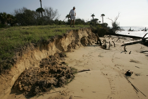
Rising seas — a sure-fire warning of an ever-warming world — hammer the barrier islands, salt marshes, and maritime forests that protect lives, property, and rare species along the Atlantic seaboard.
A recent series of studies by the U.S. Fish and Wildlife Service and the U.S. Geological Survey underscore the threat to coastal communities from North Carolina to Florida. They measure changes in sea level, land elevation, sediments, and vegetation. Combined, they paint an alarming picture.
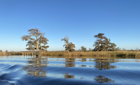
Look no further than the Cape Romain National Wildlife Refuge for global warming proof. The 22-mile-long refuge between Charleston and Georgetown — one-tenth of South Carolina’s coast — is replete with barrier islands, salt marsh salt marsh
Salt marshes are found in tidal areas near the coast, where freshwater mixes with saltwater.
Learn more about salt marsh estuaries, and oak-pine forests. Half of the state’s federally threatened loggerhead sea turtles nest along its sandy beaches, as do hundreds of thousands of migratory and wading birds.
Yet the barrier islands that protect the mainland — Bulls, Lighthouse, Marsh, and more — are disappearing with beaches breached, dunes flattened, and marshes turned into open ocean.
“The islands have definitely shrunk,” says Sarah Dawsey, the refuge manager who arrived at Cape Romain in 1986. “Marsh Island is extremely important to birds. Back in the day it was 50 acres. It’s about 10 acres now. It was the only place in the state where pelicans were nesting. You had royal and sandwich terns, oystercatchers, and wading birds, including reddish egrets. We still have nesting birds, but areas are getting washed over more frequently. There’s just not enough habitat.”
The seas off Cape Romain have risen one foot over the last half century. There’s little to no accretion, or buildup of sediment to counter the rising waters. One of the sea level-vegetation studies shows that the refuge’s salt marshes are gaining less than a millimeter of elevation (sediment mostly) each year – not enough to keep up with rising waters.
So, Cape Romain got smart, took a page from the studies’ recommendations, and joined the fight against the warming world.
'Transformation is happening’
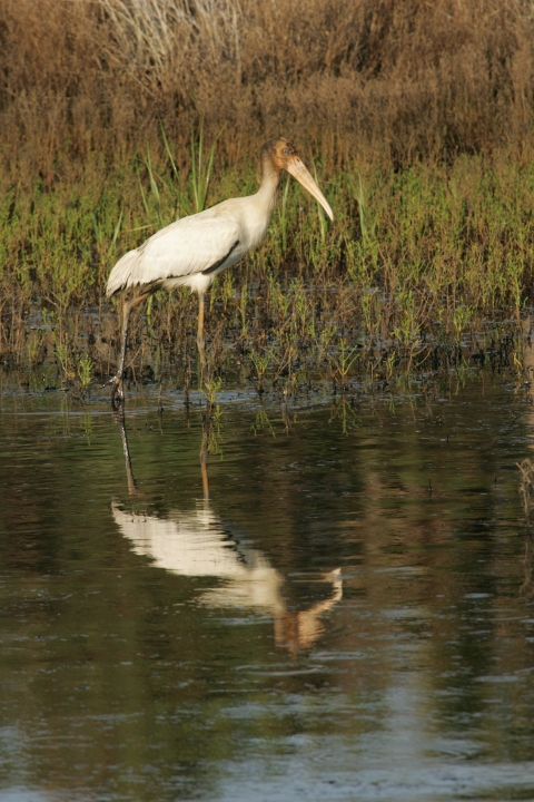
The importance of Southeastern salt marshes can not be overstated. They’re bulwarks against rising seas, hurricanes, and wicked storms and protect homes, roads, and people. They tame floods, filter ag, industrial, and municipal runoff while improving water quality. They’re fisheries for shrimp, oysters, redfish, and flounder. Long-legged storks, herons, and egrets live year-round in the mud flats, tidal pools, and sea grasses. Ducks winter there, as do federally protected species like eastern black rails, piping plovers, and red knots.
The marshes are in trouble. The seas off the coasts of Florida, Georgia, and the Carolinas have risen about seven inches since 2010 — the same amount as the previous 50 years. Expect a similar increase, or more, by 2060. The National Oceanic and Atmospheric Administration also predicts, by then, that sea level rise will cause 14 to 34 percent of existing salt marshes along the South Atlantic to disappear.
State, federal, municipal, and nonprofit groups are scurrying to hold the water line. The federal Salt Marsh Keystone Initiative pledges millions of dollars to bolster coastal wetlands via oyster reefs, beach renourishment, and “living shorelines” (plants, sand, rocks). The South Atlantic Salt Marsh Initiative, a government-military-NGO collective, seeks to protect one million acres of salt marsh across the Carolinas, Georgia, and north Florida.
Yet the outlook remains particularly dire for the wildlife refuges that dot the Atlantic.
“Five years ago, not everybody was comfortable saying, ‘Oh, yeah, these coastal wetland systems are transforming,’” says Michelle Moorman, a coastal ecologist with the Service in Raleigh. “Now, the science is there. Transformation is happening. Sea level rise is accelerating. And, now, we’ve got to figure out how to navigate all this.”
Moorman is the lead author of Will They Stay or Will They Go–Understanding South Atlantic Coastal Wetland Transformation in Response to Sea-Level Rise. The study tracks changes in wetland elevation over a decade at 18 Southeastern wildlife refuges. Historically, sea levels have fluctuated and enough sediment from upstream rivers and creeks kept the marshes intact. No more. Of the 20 sites monitored, only six gained elevation equal to, or greater, than the long-term rates of sea-level rise. And only two sites, at Waccamaw (South Carolina) and Currituck (North Carolina) refuges added enough sediment to be considered relatively healthy.
“The landscape as we know it today will not look the same in the future. The salt marsh is migrating upslope and upstream. Forested wetlands are being replaced by stands of ‘ghost forests,’” Moorman says. “We have two options: we can either build elevation in situ or we can allow the coasts to migrate.”
Sea, sediment, salt marsh
Scientists love acronyms. Moorman and colleagues came up with a couple of doozies — SET and UVVR — to explain what’s happening to South Atlantic coasts. A “surface elevation table,” or SET, delineates the height of land along the coast. “Unvegetated-vegetated ratio,” or UVVR, measures the ratio of salt marsh covered in plants with marsh not covered in plants. Less green means more open water and more likelihood that the seas are over-running the marsh.
Moorman learned of UVVR in 2020 and asked USGS (acronym!) scientists to apply the satellite-mapping data to marshes on 15 refuges across the four South Atlantic states. They then married UVVR and SET data to paint a fuller and, unfortunately, more depressing story of salt marsh loss.
At Mackay Island refuge along the North Carolina-Virginia border, for example, a prime migratory stopover for the greater snow goose, the marshes and vegetation are losing ground to the ocean. It’s the same story across the Southeast.
“This suggests that intact vegetative plains are a prerequisite for vertical stability in light of sea-level rise,” the recent study concludes.
Moorman is creating story maps with the UVVR and SET data to show marsh loss – as well as possible solutions — for a handful of refuges. At Cape Romain, for example, the salt marshes gain less than a millimeter of elevation each year — one of the lowest rates in the Southeast. Its vegetation, too, is disappearing. Consequently, its marshes are “unstable and vulnerable to break-up and conversion to open water,” the study says.
Cape Romain’s problems, though, aren’t solely due to climate devilment. The streams that feed into the refuge, the Santee River in particular, once deposited copious amounts of marsh-building sediment across the 66,300-acre refuge. But the Santee was dammed in 1941 and sediment flows diminished. Construction of the nearby Intracoastal Waterway didn’t help matters either.
Conservation corridors
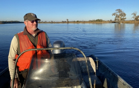
It’s a different story at Waccamaw with its wondrous mix of fresh and saltwater wetlands, old rice fields, and alluvial flood plains courtesy of the Waccamaw and Great Pee Dee Rivers. The UVVR is strong with healthy vegetation stabilizing wetlands across the 38,000-acre refuge near Myrtle Beach. And the elevation data shows that Waccamaw’s freshwater wetlands gain more than 17 millimeters a year of sediment thanks to the rivers.
“If we get enough accretion all the way down the Waccamaw River we’d be in a good position to protect all the freshwater and salt marshes from sea level rise,” says refuge manager Craig Sasser while steering a 17-foot skiff up the river.
But that’s not happening. Below the refuge, closer to the Atlantic, old cypress tree stands have turned into dead ghost forests. The freshwater wetlands are increasingly salty as the estuary creeps upriver. And the UVVR ratio becomes unstable with salt marshes becoming more vulnerable and transitioning to open water.
Sasser, eyeing ever-rising seas, is fighting back. He adjusted the refuge’s boundary, exchanging 6,849 acres in Waccamaw’s lower reaches, which have little conservation value, for 6,638 freshwater acres upstream. The inland migration adheres to the refuge’s mission “to protect and manage diverse habitat” for migratory birds and imperiled species, including bald eagles, swallow-tailed kites, and wood storks. It also helps better align Waccamaw with other lands, both publicly and privately owned, to create conservation corridors so animals, plants, and wetlands can further migrate away from the rising seas.
The recent series of FWS-USGS reports suggest similar anti-climate change strategies across the Southeast. At Mackay Island, for example, a ditch should be shut off so that sediment-laden water can flow to a marsh instead of the bay. More than $27 million in climate-fighting federal dollars is targeted for a handful of eastern North Carolina refuges for oyster reefs, marsh sills, sand dredgings, tidal gates, and pumps.
Cape Romain gets some climate help, too. The Salt Marsh Keystone Initiative sets aside $100,000 to determine if sand dredged offshore can be used to rebuild Marsh Island. And, in its biggest migratory move to date, the Service recently paid $4.7 million for a 421-acre upland addition to Cape Romain. Easier access, and two more ponds for waterfowl and waterbirds, make the Nuthatch Stowe property a natural addition to the refuge’s portfolio of fresh and saltwater amenities. But it’s the promise of a conservation corridor, and a move away from the marauding seas, that make the acquisition particularly sweet.
“It’s still a huge bird refuge — shorebirds, seabirds, wading birds, songbirds,” Dawsey says. “But there’s less habitat because of sea level rise. So, it’s absolutely necessary to renourish the existing islands, and create new islands, for the birds.”
Want to know more? Check out these studies:
Will They Stay or Will They Go — Understanding South Atlantic Coastal Wetland Transformation in Response to Sea-Level Rise: https://link.springer.com/article/10.1007/s12237-023-01225-7
Horizontal Integrity a Prerequisite for Vertical Stability: Comparison of Elevation Change and the Unvegetated-Vegetated Marsh Ratio Across Southeastern USA Coastal Wetlands: https://link.springer.com/article/10.1007/s12237-023-01221-x
Coastal Wetlands Status in Southeast Region Refuges: https://geonarrative.usgs.gov/uscoastalwetlandsynthesis/
The State of Waccamaw NWR's Coastal Wetlands: https://storymaps.arcgis.com/stories/4dbf28b2523345b5809b6a686de6bb3c
Understanding Living Shorelines: https://www.fisheries.noaa.gov/insight/understanding-living-shorelines
The State of Coastal North Carolina NWR Complex’s Marshes: https://storymaps.arcgis.com/stories/f9932a1d8310447886e5fce797efcb20