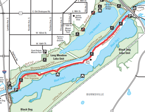
- Trail type: Out-and-back, paved. To make this a one-way, park a shuttle vehicle at one of the trailheads.
- Suitable for: Hike, bike, wheelchair, rollerblade, stroller, wagon
- Distance: Approximately 3.6 miles one-way, 7.2 miles out-and-back
- Parking: Minnesota Riverfront Park (City of Burnsville) 600 Black Dog Rd, Burnsville, MN 55337. A portable restroom is available. Or at Jens Caspersen Landing (DNR) No Street Address. In Eagan, take Hwy 13 north/east to Silver Bell Rd, then north to Nichols Rd, then turn right and drive to the parking area under the Hwy 77 bridge. A State Park permit is required to park here.
- Description: Hike with a friend (park a car at each end) to complete a 5K on this trail, or complete a 10K by returning to your starting point. This trail winds through forest and along the river. A short spur leads to an observation deck overlooking Black Dog Lake. Look for migrating birds on the lake and along the river.
| - This route in only available on Saturdays and Sundays. Trail closed Mondays-Fridays until further notice for state trail construction and repair.
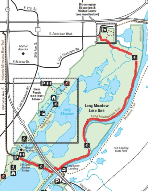
- Trail type: Out-and-back, gravel. To make this a one-way, park a shuttle vehicle at one of the trailheads.
- Suitable for: Hike, off-road bike
- Distance: Approximately 3.7 miles one-way, 7.4 miles out-and-back
- Parking: Bloomington Education and Visitor Center 3815 American Blvd E, Bloomington, MN 55425. Portable restrooms are available at the Bloomington Education and Visitor Center parking lot. Water is available inside the visitor center Thursdays-Sundays, 10 a.m. - 4 p.m. Or at the Old Cedar Ave Trailhead 9551 Old Cedar Ave S, Bloomington, MN 55425. Restrooms and water are available.
- Description: Hike with a friend (park a car at each end) to complete a 5K on this trail, or complete a 10K by returning to your starting point. This rustic, two-track gravel trail travels through floodplain forest and marshlands. Look for fox, otters, coyote, eagles, turkeys and more along your route. At Old Cedar Avenue Bridge, look for migrating waterfowl and sandhill cranes.
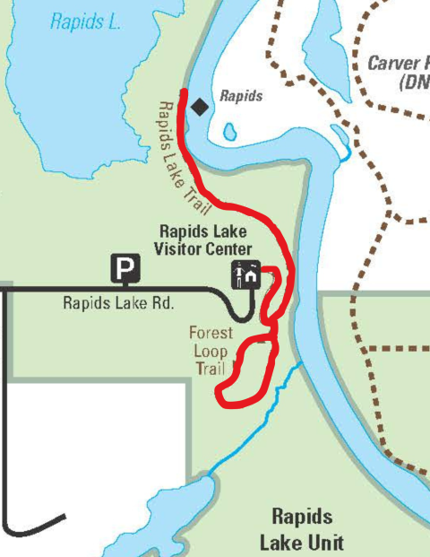
| - Trail type: Out-and-back with small loop as part of route, asphalt and natural surface
- Suitable for: Hike, off-road bike
- Distance: Approximately 2.6 miles out-and-back with one loop of Forest Loop trail. 3.2 miles (5k) if taking loop coming from both directions.
- Parking: Rapids Lake Education and Visitor Center 15865 Rapids Lake Rd, Carver, MN 55315. Restroom accessible from outside during refuge open hours, 5 am - 10 pm daily. Additional restrooms and water available during visitor center open hours, Saturdays and Sundays 10 am - 5 pm.
- Description: This route starts from the Rapids Lake Visitor Center, following the asphalt trail until reaching the forest loop trail. This mostly level trail courses through oak and hickory forest, with a brief view of a slough connecting to Long Lake. After this short loop, continue along the Rapids Lake trail, which follows river bottom forest and marsh for much of its length. At 0.6 miles, you will pass a pond at the base of the ridge. River rapids can be viewed (at low river levels) 1.0 mile from the visitor center. Return along the same path to the Visitor Center. Look for tracks from raccoons and deer.
|


