Written By

Hulē‘ia National Wildlife Refuge (NWR), located on the lush Island of Kaua‘i, was established in 1973 to aid in the recovery of threatened and endangered species. The 241-acre refuge provides secluded habitat for endangered waterbirds and threatened nēnē (Hawaiian goose) in a river valley surrounded by steep wooded hillsides. The topography not only makes the Hulē‘ia valley a unique refuge for birds— it also shaped the area’s rich history.
Secluded Sanctuary
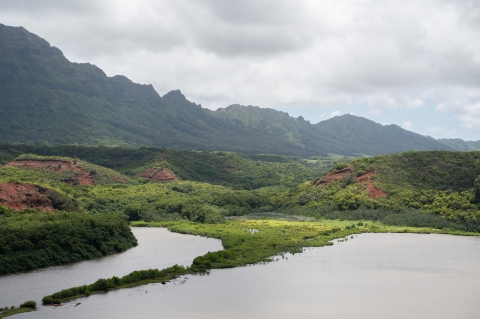
Hulē‘ia NWR is a wetland ecosystem situated within the heart of the Hulē‘ia Valley of Kaua‘i. It is bounded to the South by the Hulē‘ia River, the primary waterway that feeds the Nawiliwili Bay watershed, and to the East by the Alakoko Fishpond, listed on the National Register of Historic Places. Steep, wooded hillsides enclose the refuge, which provides a secluded haven capable of supporting a biodiverse ecosystem. Stories of the land speak of a people deeply intertwined with the land and natural elements.
Hulē‘ia NWR’s climate is wet and warm with 50-75 inches of rainfall annually, and an average temperature of 73° F. The soil is nutrient-rich soil making the valley ideal for a variety of plant and animal life.
Southward from the Refuge, is the Hā‘upu Ridge, a mountain range that runs parallel to the Hulē‘ia River. Hā‘upu Ridge holds immense geological and cultural importance. Geologists identify this mountain range as the southern arc of the volcanic crater that formed the island of Kaua‘i. Erosion sculpted the region’s distinct valleys and streams over millions of years, creating the unique topography.
Hā‘upu Ridge serves as a geological divide, separating the arid Kōloa region to the south from the lush northern landscape of Līhu‘e. In Hawaiian mythology, the ridge symbolizes the influence of powerful deities whose tumultuous love affairs shaped the topography between Kōloa and Līhu‘e.
According to some Hawaiian cultural practitioners, the fire goddess Pele governs the arid expanse of Kōloa, reflecting her harsh and commanding nature. In contrast, her estranged lover, the pig demi-god Kamapua‘a, associated with taro cultivation and soil fertility, resides in the verdant Līhu‘e area. The rugged terrain of the area is said to be attributed to the turbulent interactions of these two deities, marking the dramatic landscape with the echoes of their intermittent love affairs.
It is believed the influence of Pele and Kamapua‘a also impacts the microclimates of Kōloa and Līhu‘e. During periods of drought in Kamapua‘a's lush domain, it is believed that Pele has taken residence, and conversely, heavy rains in Pele’s arid territory are seen as a sign of Kamapua‘a's presence.
Additionally, several heiau (Hawaiian temples) have been discovered within the region, suggesting this area was home to an active community that held a deep sanctity for the land.
The Breadbasket
“Places like Hulē‘ia are prime growing areas,” says Jennifer Waipa, who is an archaeologist by training and the former archaeologist and current visitor services manager for the Kaua‘i National Wildlife Refuge Complex (KNWRC). She has been working at the Refuge Complex for 15 years. According to Waipa, fruit trees and other domestic vegetation such as mai‘a (banana), ‘ulu (breadfruit), and monkeypod can serve as great cultural indicators. Vegetation can disclose insights about past sustenance, resource use, and settlement.
Waipa calls this area “the breadbasket" of Kaua‘i, with a bounty stemming largely from the diverse water exchanges taking place within the Hulē‘ia region.
Most of what we know about the historic Hulē‘ia Valley comes from a 1995 archaeological study conducted for the refuge. This research, along with other historical documents, suggest wetland agriculture was practiced through the mid-nineteenth century within the valley’s historic floodplains. Based on their findings, archaeologists determined that the cultivation of lo‘i kalo (taro fields) dates back to early settlement of the islands.
Aquaculture was productive within the valley as well. Fishpond sediments and structural remnants still exist today in the area spanning all the way from the valley to Nawiliwili Bay.
During periods of high tide, saltwater from the Nawiliwili Bay travels for miles upstream, reaching the Hulē‘ia Valley. Early Hawaiians studied the tidal fluctuations and used them to capture fish, mollusks, and crustaceans in brackish ponds.
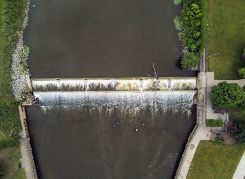
Although many of these fishponds have long been abandoned or destroyed, the Alakoko Fishpond is still active to this day and is one of the largest intact brackish water fishponds on Kaua‘i.
Changing Communities – From Kalo to Rice
Traditional Hawaiian kalo cultivation and settlements were gradually displaced by changes in land use across the main Hawaiian Islands in the late 19th and early 20th century. Many kalo fields were converted into rice paddies and cattle pastures, aligning with the dietary preferences of laboring Chinese and Japanese immigrants who were brought in by sugar plantation managers to work the fields.
While the overall population’s palate had changed from poi to rice, Hawaiians continued to cultivate their taro in addition to crops made popular by their new neighbors of Chinese and Japanese descent, (Shapiro & Cleghorn, 1995).
Integration between the diverse ethnic communities can further be seen in historic infrastructure remains (Shapiro & Cleghorn, 1995). Ruins of a school discovered on a slope overlooking the Hulē‘ia Valley indicate there was a substantial local population, capable of supporting an education system.
Sugar Rush
In the ensuing decades, Kaua‘i’s landscape continued to transform as the economy shifted towards sugarcane production.
Sugar cultivation was not new for the island. Native Hawaiians had long grown this perennial grass for consumption and to naturally clean their teeth. However, in the mid-1800s, sugarcane became commercialized by western entrepreneurs who saw how profitable it was on other islands.
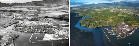
Around the late 1840s, the Hulē‘ia Valley was surrounded by developing sugarcane plantations in Kōloa and Līhu‘e. Gradually, these plantations drew people away from their rural way of life and into these budding urban regions.
Within the Hulē‘ia Valley, rice became a staple. It was exported to the continental United States to support the Gold Rush and immigrant families, while kalo was grown mainly as sustenance for local Hawaiians. These primary crops were still being cultivated when a wealthy German businessman named Herman Widemann, purchased land in the Hulē‘ia and Halehaka Valleys and established the Grove Farm Corporation in 1854. These lands were later bought by missionary descendant George Norton Wilcox in 1870.
The End of the Sugarcane Era
By the 1950s, Hawai‘i's sugar industry faced a decline due to labor shortages caused by changes in immigration laws, the adoption of agricultural mechanization reducing manual labor demand, and global competition in the sugar market. The shift in land use priorities toward urbanization and other economic activities, along with changes in United States governmental policies, further contributed to the industry's challenges.
Mills steadily began to shut down.
Workers were now displaced from their residential camps on sugarcane plantations and had to figure out a new way. George Wilcox strategically redirected his business model to meet this need for housing and prevented the Grove Farm Corporation from going under. Several subdivision projects were subsequently spearheaded by the Grove Farm Corporation across the towns of Puhi, Kōloa, and Līhu‘e, further drawing people away from the Hulē‘ia Valley. While some residents were bound to their ancestral roots through their kuleana lots (inholdings) within Hulē‘ia, the valley was left relatively void of people at this time.
In 1973, the opportunity arose for the U.S. Fish and Wildlife Service to purchase 241 acres of land in the Hulēʻia Valley using Land and Water Conservation funds. Hulē‘ia NWR was born with a vital objective: to provide open wetlands as feeding and nesting habitat for endangered waterbird species. It would soon become a conservation stronghold for several avian species in the succeeding decades.
Modern Stewards
With USFWS’s establishment of the Huleia NWR, the landscape continued to transform as waterbird conservation became a priority. Some of the Refuge’s biggest transformations began in 2001 when USFWS volunteer Chadd Smith joined KNWRC. Over 21 years he rose from volunteer to staff engineering equipment operator, dedicating countless hours on and off the clock to developing and refining wetland management techniques at Hulē‘ia NWR.
Smith said in a 2023 interview that after years of working at the Refuge, he noticed two main factors that draw waterbirds to an area. The first of which is the type of vegetation present. Waterbirds rely on wetland vegetation for shelter and food, but Smith said when he first joined KNWRC “you couldn’t find hardly a sedge out there in those ponds.” The ponds were completely covered with invasive California grass, preventing native waterbirds from utilizing them.
Smith gradually cleared the ponds from Hulē‘ia using a combination of wetland management techniques. Over the years, the number of birds in Hulē‘ia started to increase as their habitat improved.
Tidal influence from the Hulē‘ia River was another key benefit to creating usable habitat, especially for Hawaiian stilts, in Hulē‘ia. Smith observed that periods of high tide deliver nutrients from the Nawiliwili Bay into the Hulē‘ia floodplains. Meanwhile, when the water level subsides, it exposes new areas of the ponds for waterbirds to forage and nest in. This naturalized system is what some of these endangered waterbirds prefer, so for Smith, allowing a more hands off approach to water level management within the wetland management units using tidal gates was key.
These habitat restoration projects Smith spearheaded helped foster the ideal habitat conditions for the native waterbirds and yielded remarkable results; a Statewide bird count in 2016-2017 revealed that Hulē‘ia had the most waterbirds per acre across the entire state.
A Conservation Stronghold
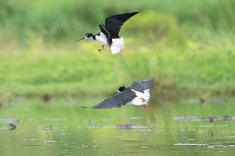
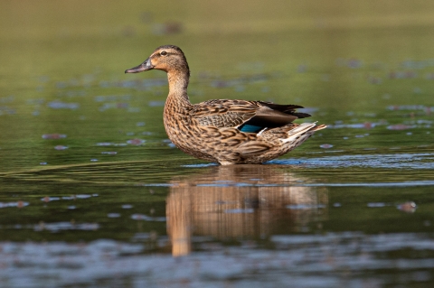
Today, the Hulē‘ia NWR is one of just two National Wildlife Refuges in Hawaiʻi with all five federally listed waterbirds: koloa maoli (Hawaiian duck), ‘alae ke‘oke‘o (Hawaiian coot), ‘alae ‘ula (Hawaiian moorhen), ae‘o (Hawaiian stilt), and the nēnē (Hawaiian goose). Hanalei National Wildlife Refuge, also on Kauaʻi, is the other. Additionally, 26 migratory and non-native bird species utilize the Refuge’s wetland units throughout the year.
Hulē‘ia NWR holds immense biological importance. According to Heather Abbey, KNWRC refuge manager, “Kaua‘i is the only place other than Ni‘ihau that serves as a stronghold for genetically pure koloa.”
Mallard-koloa hybridization is a current threat to the endangered koloa population. Mallards were introduced from the continental United States and breed with the native koloa. This has led to the loss of their unique genetic composition. Unfortunately, the majority of the koloa found on the other Hawaiian Islands have already hybridized with feral mallards, leaving the endangered koloa at risk of blinking out. If pure koloa are not reintroduced back to the other islands and feral mallards are not removed, then it could lead to a genetic collapse of pure koloa.
There are less than 2,000 genetically pure koloa left in the world ( ECOS ECOS
Environmental Conservation Online System (ECOS) serves a variety of reports related to FWS Threatened and Endangered Species.
Learn more about ECOS : Species Profile, n.d.). The majority of these nonhybridized koloa are found on Kaua‘i (Wells et al., 2019). Because of this, Abbey emphasizes, “the recovery of this species basically depends on the wildlife refuges here on Kaua‘i.”
Hulē‘ia’s ability to safeguard the nonhybridized koloa population serves as a compelling example of how crucial this refuge is for the numerous avian inhabitants that depend on its wetlands.
Community Partners
The USFWS works closely with our partner, Mālama Hulēʻia, who are aiding in the restoration of wetland habitat and surrounding upland breeding areas for federally listed waterbirds and the local community. Mālama Hulē‘ia is a nonprofit organization focused on the restoration and cultural preservation of the Hulē‘ia Valley. They have recently received grant funding, provided by the USFWS, to remove invasive red mangrove that threaten the Hulē‘ia watershed and encroach on waterbird habitat. The scope of their restoration projects will encompass red mangrove removal along the Hulē‘ia River and will extend onto Refuge lands.
50 Years In
At dusk, the Refuge comes alive. The beating wings of a flock of nēnē can be heard as they descend into a pond. Their arrival is greeted by a chorus of krrps and kurr’uks from nearby waterbirds. The croak of bullfrogs and rustle of unseen life fills the nighttime ambience.
To safeguard the delicate life cycles of these endangered residents, the Hulē‘ia NWR is closed to the public. However, there are ways to get involved at the Refuge. Stay connected with the Kaua‘i National Wildlife Refuge on our website and Facebook page to learn about volunteer opportunities and ranger led hikes.
If you are on Kaua‘i, glimpses of this hidden gem can be seen from the Alakoko Fishpond Overlook, located just outside of Līhu‘e.
Works Cited:
ECOS: Species profile. (n.d.).
Young, P. T. (2023, February 25). Keolewa Heiau. Images of Old Hawaiʻi.
Shapiro, L., & Cleghorn, P. (1995). ARCHAEOLOGICAL INVESTIGATIONS OF HULE’IA NATIONAL WILDLIFE REFUGE HA’IKU, NIUMALU, KAUA’I (J-4057). BioSystems Analysis, Inc.
TenBruggencate, J. (2019, February 14). About the Huleia. Malama Huleia.